Wyoming Highway 296
| ||||
|---|---|---|---|---|
| Chief Joseph Scenic Byway | ||||
| Route information | ||||
| Maintained by WYDOT | ||||
| Length: | 45.96 mi[1] (73.97 km) | |||
| Major junctions | ||||
| West end: |
| |||
| East end: |
| |||
| Location | ||||
| Counties: | Park | |||
| Highway system | ||||
| ||||

Wyoming Highway 296 also known as the Chief Joseph Scenic Byway is in the U.S. state of Wyoming and follows the route taken by Chief Joseph as he led the Nez Perce Indians out of Yellowstone National Park and into Montana in 1877 during their attempt to flee the U.S. Cavalry and escape into Canada.
Route description
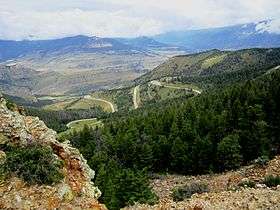
Wyoming Highway 296 is a 45.96-mile (73.97 km) long scenic highway in northern Park County. Highway 296 begins its western end at U.S. Route 212 (Beartooth Highway) fourteen miles southeast of Cooke City, Montana.[2] WYO 296 travels southeasterly as it winds through the Shoshone National Forest and through the Absaroka Mountains and then passes through Dead Indian Pass. After almost 46 miles, WYO 296 reaches its eastern end at Wyoming Highway 120, 17 miles north of Cody.[2][3]
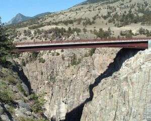
Highway 296 crosses Sunlight Creek Bridge, the highest in Wyoming.
Major intersections
The entire route is in Park County.
| Location | mi | km | Destinations | Notes | |
|---|---|---|---|---|---|
| | 0.00 | 0.00 | Western terminus WYO 296 | ||
| | 45.96 | 73.97 | Eastern terminus WYO 296 | ||
| 1.000 mi = 1.609 km; 1.000 km = 0.621 mi | |||||
References
- ↑ Wyoming Department of Transportation Reference Marker Book - November 2004 (PDF) (Map). WYDOT. Archived from the original (PDF) on July 17, 2011. Retrieved 2011-04-04.
- 1 2 aaroads.com - Wyoming Routes 200-299
- ↑ Overview Map of Wyoming Highway 296 (Map). Yahoo Maps. Retrieved 2011-04-05.
External links
- Wyoming State Routes 200-299
- WYO 296 - WYO 120 to US 212
- National Scenic Byways Program. "Chief Joseph Scenic Highway". Retrieved 2006-07-08.
- Chief Joseph Scenic Byway - Wyoming Tourism