Wyville
Wyville with Hungerton, or Hungerton-cum-Wyville is a village and civil parish in the South Kesteven district of Lincolnshire, England, and situated approximately 5 miles (8 km) south-west from Grantham The whole parish covers about 1,670 acres (6.8 km2). The population is included in the civil parish of Little Ponton and Stroxton.
The village is an ecclesiastical parish of the Harlaxton Group of the Grantham Deanery in the Diocese of Lincoln. The incumbent is Rev Keith Hanson.[1][2]
Wyville

52°51′14″N 0°41′42″W / 52.854°N 0.695°W
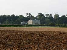
Wyville is a small hamlet consisting mainly of a collection of farm buildings and a 19th-century church.
A small spring runs to the south of the hamlet, toward the Cringle Stream at Stoke Rochford, an early tributary of the River Witham.[3]
Hungerton
52°51′32″N 0°41′56″W / 52.859°N 0.699°W
Hungerton is a small hamlet set about a half mile northwest of Wyville. Hungerton has been the population centre of the parish in recent centuries.
History
Both villages are listed in the Domesday Book, and at the time of the survey were larger than today.[4][5]
St Catherine has long been associated with Wyville. Ancient stone coffins have been found on what may have been the site of the original church.[6] The present church was built in 1858.[6][7]
In 1848 Samuel Lewis described the parish as:
- "WYVILL, a parish, in the union of Grantham, wapentake of Loveden, parts of Kesteven, county of Lincoln, 6 miles (N. W.) from Colsterworth; containing, with Hungerton, 137 inhabitants. The living is a discharged rectory, with that of Hungerton united; net income, £35; patron, the Bishop of Lincoln. The church is in ruins, and the inhabitants attend that at Harlaxton."[8]
A few years later John Marius Wilson said of the parish:
- "WYVILLE-WITH-HUNGERTON, a parish in Grantham district, Lincoln; 3½ miles W by S of Great Ponton r. station, and 5 SSW of Grantham. Post town, Colsterworth, under Grantham. Acres, 1,670. Real property, £1,840. Pop., 155. Houses, 28. The living is a double rectory in the diocese of Lincoln. Value, £35. Patron, the Bishop of L. The church was built in 1858."[7]
References
- ↑ "ecclesiastical parish details".
- ↑ "Web site of Harlaxton group of parishes, including parish magazine".
- ↑ Sheet 130 Grantham:Sleaford & Bourne (Map) (C2- ed.). 1:50000. OSGB. ISBN 978-0-319-22929-3.SK884291
- ↑ Historic England. "Early history of Wyville (323572)". PastScape. Retrieved 15 January 2011.
- ↑ Historic England. "Shrunken medieval village of Hungerton (323789)". PastScape. Retrieved 15 January 2011.
- 1 2 Historic England. "Ancient stone coffins (323555)". PastScape. Retrieved 15 January 2011.
- 1 2 Wilson, John Marius, ed. (1872). Imperial Gazetteer of England and Wales.
- ↑ Lewis, Samuel, ed. (1848). A Topographical Dictionary of England. London: Samuel Lewis & Co. pp. 703–707 'Wyke – Wyvill'.
External links
 Media related to Wyville at Wikimedia Commons
- "Wyville (Wyville with Hungerton, or Hungerton cum Wyville)", Genuki.org.uk
England Portal | |
| Unitary authorities | |
| Boroughs or districts | |
| Major settlements |
|
| Topics | |