Yarenga River
Coordinates: 62°07′47″N 49°04′29″E / 62.12972°N 49.07472°E
| Yarenga Russian: Яренга | |
|---|---|
 | |
| Country | Russia |
| Basin | |
| River mouth | Vychegda |
| Basin size | 5,140 square kilometres (1,980 sq mi)[1] |
| Physical characteristics | |
| Length | 281 km (175 mi)[1] |
| Discharge |
|

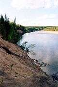
The Yarenga (Russian: Яренга) is a river in the Ust-Vymsky District of the Komi Republic and in the Lensky District of the Arkhangelsk Oblast in Russia. It is a right tributary of the Vychegda River. The river is 281 kilometres (175 mi) long, and its drainage basin covers 5,140 square kilometres (1,980 sq mi). The principal tributaries are the Vezhay River (left) and Uktym River (right). The Yarenga is the main river of the Lensky District north of the Vychegda and collects virtually all the drain of that area.
The source of the Yarenga is near the village of Vezhayka in the Komi Republic. The Yarenga flows to the north-west through primeval pine and larch forests, enters the Arkhangelsk Oblast, and in the village of Yarenga turns south-west. It is noted for its many rapids. In the village of Ust-Ocheya, where it accepts the Ocheya River from the left, it turns south-east. Yarensk is on the left bank, approximately 3 kilometres (2 mi) from the river course. The Yarenga empties into the Vychegda River about 5 kilometres (3 mi) downstream from Yarensk.
References
External links
-
 Media related to Yarenga River at Wikimedia Commons
 - Река Яренга (in Russian). State Water Register of Russia. Retrieved 1 June 2011.