Zagorica nad Kamnikom
| Zagorica nad Kamnikom | |
|---|---|
 | |
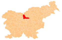
 Zagorica nad Kamnikom Location in Slovenia | |
| Coordinates: 46°15′38.15″N 14°36′4.97″E / 46.2605972°N 14.6013806°ECoordinates: 46°15′38.15″N 14°36′4.97″E / 46.2605972°N 14.6013806°E | |
| Country |
|
| Traditional region | Upper Carniola |
| Statistical region | Central Slovenia |
| Municipality | Kamnik |
| Area | |
| • Total | 0.39 km2 (0.15 sq mi) |
| Elevation | 434.7 m (1,426.2 ft) |
| Population (2002) | |
| • Total | 155 |
| [1] | |
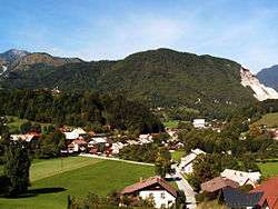
Zagorica nad Kamnikom (pronounced [zaɡɔˈɾiːtsa nat ˈkaːmnikɔm]; German: Sagoritz)[2] is a settlement on the right bank of the Kamnik Bistrica River in the Municipality of Kamnik in the Upper Carniola region of Slovenia.
Name
The name of the settlement was changed from Zagorica to Zagorica nad Kamnikom in 1953.[3] In the past the German name was Sagoritz.[2]
Church
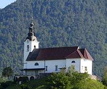
Saint Benedict's Church
The Stranje parish church, dedicated to Saint Benedict, is built on a small hill at the southern end of the settlement. The chapel of Our Lady of the Snows on the Big Pasture Plateau (Slovene: Velika planina) also belongs to this parish.[4]
References
- ↑ Statistical Office of the Republic of Slovenia
- 1 2 Leksikon občin kraljestev in dežel zastopanih v državnem zboru, vol. 6: Kranjsko. 1906. Vienna: C. Kr. Dvorna in Državna Tiskarna, p. 30.
- ↑ Spremembe naselij 1948–95. 1996. Database. Ljubljana: Geografski inštitut ZRC SAZU, DZS.
- ↑ Družina, Slovenia's RKC publication website
External links
This article is issued from Wikipedia - version of the 11/7/2014. The text is available under the Creative Commons Attribution/Share Alike but additional terms may apply for the media files.