Zapallar
| Zapallar | ||||||
|---|---|---|---|---|---|---|
| Town and Commune | ||||||
|
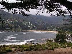
Beach of Zapallar | ||||||
| ||||||
| Coordinates: 32°33′13″S 71°27′32″W / 32.55361°S 71.45889°WCoordinates: 32°33′13″S 71°27′32″W / 32.55361°S 71.45889°W | ||||||
| Country |
| |||||
| Region |
| |||||
| Province | Petorca | |||||
| Government[1] | ||||||
| • Type | Municipality | |||||
| • Alcalde | Nicolás Cox Urrejola (RN) | |||||
| Area[2] | ||||||
| • Total | 288.0 km2 (111.2 sq mi) | |||||
| Elevation | 50 m (160 ft) | |||||
| Population (2012 Census)[2] | ||||||
| • Total | 5,933 | |||||
| • Density | 21/km2 (53/sq mi) | |||||
| • Urban | 4,744 | |||||
| • Rural | 915 | |||||
| Sex[2] | ||||||
| • Men | 2,914 | |||||
| • Women | 2,745 | |||||
| Time zone | CLT [3] (UTC-4) | |||||
| • Summer (DST) | CLST [4] (UTC-3) | |||||
| Area code(s) | 56 + 33 | |||||
| Climate | Csb | |||||
| Website | Municipality of Zapallar | |||||


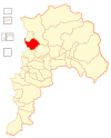
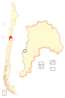
Zapallar is a Chilean town and commune located in the Petorca Province, Valparaíso Region. The commune spans an area of 288.0 km2 (111 sq mi).[2]
Zapallar is a quaint and elegant seaside resort town, which has played a significant role as a playground for Chile's economic and political elites. Together with its neighboring towns of Cachagua and Maitencillo, Zapallar represents the heart of one of Chile's most attractive and exclusive vacation areas. The town is built along steep hills along a protected horseshoe bay with high quality white sand. To the north and south of the town center, the geography is rugged, characterized by steep cliffs and rocky precipices. Zapallar is an attractive town, popular with tourists, due to its majestic views and the many historic mansions that now sit side by side along more contemporary expensive homes. A mediterranean micro-climate is conducive to cultivating the many attractive gardens that historically adorn the town. One of the town's most attractive features is the stone masonry promenade that extends along the beach for three kilometers.
Zapallar is located two hours northwest of Santiago and seventy minutes north of greater Valparaíso and Viña del Mar.
Demographics
According to the 2002 census of the National Statistics Institute, Zapallar has 5,659 inhabitants (2,914 men and 2,745 women). Of these, 4,744 (83.8%) lived in urban areas and 915 (16.2%) in rural areas. The population grew by 24.3% (1,105 persons) between the 1992 and 2002 censuses.[2]
Administration
As a commune, Zapallar is a third-level administrative division of Chile administered by a communal council, headed by an alcalde who is directly elected every four years. The 2012-2016 alcalde is Nicolás Cox Urrejola. The communal council has the following members:[1]
- Liliana Figueroa Arancibia (RN)
- Carolina Letelier Riumallo (DC)
- Sergio Correa Undurraga (IND-RN)
- Gonzalo Fernández Osorio (IND-UDI)
- Federico Ringeling Hunger (IND-UDI)
- Fidel Rojas Guerra (PPD)
Within the electoral divisions of Chile, Zapallar is represented in the Chamber of Deputies by Mr. Eduardo Cerda (PDC) and Mrs. Andrea Molina (UDI) as part of the 10th electoral district, (together with La Ligua, Petorca, Cabildo, Papudo, Puchuncaví, Quintero, Nogales, Calera, La Cruz, Quillota and Hijuelas). The commune is represented in the Senate by Ignacio Walker Prieto (PDC) and Lily Pérez San Martín (RN) as part of the 5th senatorial constituency (Valparaíso-Cordillera).
See also
References
- 1 2 "Municipality of Zapallar" (in Spanish). Retrieved 28 July 2010.
- 1 2 3 4 5 "National Statistics Institute" (in Spanish). Retrieved 28 July 2010.
- ↑ "Chile Time". WorldTimeZones.org. Archived from the original on September 11, 2007. Retrieved 2010-07-28.
- ↑ "Chile Summer Time". WorldTimeZones.org. Archived from the original on September 11, 2007. Retrieved 2010-07-28.
External links
| Wikimedia Commons has media related to Zapallar. |
- (Spanish) Municipality of Zapallar