Zarcero
Zarcero is the capital city of the canton of Zarcero in the province of Alajuela in Costa Rica. It is also the name of the distrito (district) that includes the city. The district of Zarcero covers an area of 12.01 km²,[1] and has a population of 4,277.[2]
Geography
The city lies at an elevation of 1,736 meters above sea level[1] in the Cordillera Central (Central Mountain Range) of Costa Rica, 50 kilometers northwest of the provincial capital city of Alajuela and 27 kilometers southeast of Ciudad Quesada.
Zarcero, known for its brisk mountain climate, lies in a dairy and agricultural area also noted for the local enterprises that practice organic farming. Distinctive jams, cheese and other dairy products are among the items produced.

History
Zarcero was granted the title of "ciudad" (city) by a law on July 24, 1918.
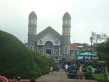
Places of interest

Parque Francisco Alvarado: The park sits in front of the church at the town center. It is noted for its topiary garden produced and maintained by Evangelisto Blanco since the 1960s. Shrubs in the park have been trimmed into the shapes of various animals, including some that are quite abstract and bizarre.
Iglesia de San Rafael: Zarcero's pink and blue church was constructed in 1895. The interior features very nice paintings of the stations of the cross. Materials for the construction of the church are not what they seem. Columns are painted to look like marble, and the exterior is metal siding, not brick as it appears.
References
External links
Coordinates: 10°11′N 84°24′W / 10.183°N 84.400°W