Zborov Castle
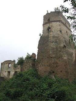
Ruins of Zborov Castle (Zborovský hrad, also called Makovica) are situated near the village of Zborov in East Slovakia. The oldest written mention of the castle comes from the 13th century but older fortification had existed before. Previously fortifications were built on a nearby hill called Hradske from the Slavic Hrad for castle
To reach the castle turn right off the main Bardejov to Zborov road just after the sign for the village. From the bridge it is a nice ten- to fifteen-minute walk up the hill to the castle. In the village there is a tourist information office, Obrancov Mieru 10, with further information on the castle.
Legends
Local legends say that the castle was originally to be built on the nearby higher hill of Hradske but all the stones placed there to build the castle mysteriously moved during the night onto the nearby lower hill on which it now stands. Rumours held that Hradske was the site of a gate into hell and that devils were moving the stones during the night to stop the gate being blocked. Eventually the efforts to build the castle on Hradske were abandoned and construction moved to the current site. Later the devil who was responsible for moving the stones was caught and bricked up in the walls of the highest tower in the castle where his horns can still be seen today. It is widely believed however, that the workers didn't want to carry the stones up to the original site as it was too high and so they secretly moved their work from the day to the smaller hill during the night. They then spread the tales about hauntings so that construction would be moved to the easier to climb hill.
Preservation
A local group has been formed to prevent further deterioration of the ruins. Work so far has included cutting all trees within 20 metres of the outer curtain wall to stop the roots undermining the foundations.
Pictures of work during winter 2009 / 2010
External links
zborov information Slovak only
Zborov at castles.sk
Coordinates: 49°21′33″N 21°18′27″E / 49.35917°N 21.30750°E