Zealandia Bank
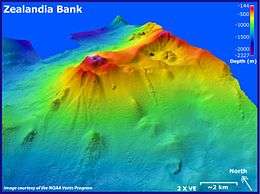 Zealandia Bank submarine volcano, looking toward the northeast | |
 | |
| Geography | |
|---|---|
| Location | Pacific Ocean |
| Coordinates | 16°53′N 145°51′E / 16.883°N 145.850°E |
| Archipelago | Northern Mariana Islands |
| Highest elevation | 1 m (3 ft) |
| Administration | |
|
United States | |
| Commonwealth | Northern Mariana Islands |
| Demographics | |
| Population | - uninhabited - (2010) |
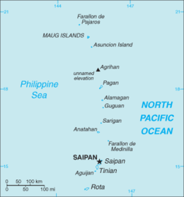
Zealandia Bank, also known as Farallon de Torres or Piedras de Torres in Spanish, or Papaungan in Chamorro consists of two rocky pinnacles about 1.5 kilometers apart, in the Northern Mariana Islands in the Pacific Ocean. One reaches a height of approximately 1 metre (3.3 ft) at low tide; the other does not normally broach the surface. They are located 11 nautical miles (20 km) north-northeast from Sarigan, in between Sarigan and Guguan, but because of their small size, they are not listed in most maps. Zealandia Bank is one of 18 units within the Mariana Arc of Fire National Wildlife Refuge,(AKA Volcanic Unit) of the Marianas Trench Marine National Monument.[1]
Zealandia Bank is the exposed portion of the peak of an eroded underwater volcano. In 2004, a survey by NOAA discovered active fumaroles, including possible volcanic activity.
Zealandia Bank was named in 1858 after the British barque Zealandia.[2] [3] The area is part of the United States Commonwealth of the Northern Mariana Islands.
References
External links
- Zealandia Bank. Pascal Horst Lehne and Christoph Gäbler: Über die Marianen. Lehne-Verlag, Wohldorf in Germany 1972.
- Sharks at Zealandia Bank
.
| Colonies |
| |||||||
|---|---|---|---|---|---|---|---|---|
| Concessions |
| |||||||
| Unrecognised |
| |||||||

Saipan (capital) | |
| Topics |
|
| Islands |
|
| Municipalities | |