Zumalai

Subdistrict of Zumalai
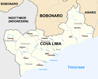
Location of Zumalai city in the east of Cova-Lima district.
Zumalai is a city[1] and subdistrict (former Mape-Zumalai) in East Timor. The subdistrict has been part of Cova Lima District since 2003. Before that, it was part of Ainaro District. The Zumalai subdistrict has six main villages: Fatuleto, Raimea, Zulo, Mape, Lour, and Taisilin.[2]
Language
There are three main local languages in Zumalai subdistrict, Bunak, Kemak, and Tetun-Terik.
Notes
- ↑ Zumalai (Approved) at GEOnet Names Server, United States National Geospatial-Intelligence Agency
- ↑ Atambua, Indonesia, Sheet SC 51-08 (topographic map, scale 1:250,000), Series U-502, United States Army Map Service, 1963
Coordinates: 9°09′27″S 125°27′02″E / 9.15750°S 125.45056°E
This article is issued from Wikipedia - version of the 5/28/2016. The text is available under the Creative Commons Attribution/Share Alike but additional terms may apply for the media files.