Zyuratkul National Park
| Zyuratkul National Park | |
|---|---|
| Зюраткуль | |
|
IUCN category II (national park) | |
|
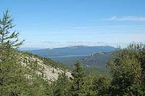
Zyuratkul' range and Zyuratkul' lake as seen from Nurgush range. | |
 | |
| Location | Chelyabinsk Oblast, Russia |
| Coordinates | 54°50′56″N 58°56′26″E / 54.84889°N 58.94056°ECoordinates: 54°50′56″N 58°56′26″E / 54.84889°N 58.94056°E |
| Established | 1993 |
Zyuratkul National Park (Russian: Зюраткуль) is a Russian national park established in 1993 in the southern part of Satkinsky Raion (Chelyabinsk Oblast, Urals). The park lies about 30 km south of Satka and 200 km west of Chelyabinsk.
Notable features include Zyuratkul' Lake, a rare mountainous body of water for the Urals 754 m above sea level, with a surface area of 13,2 km2 and a maximum depth of 8 m. Water is slightly mineralised (≈50 mg/L). Because of its clear water and spectacular landscape around, Zyuratkul' is often called "Ural Ritsa".[1]
Also remarkable is a number of mountain ranges, among them Zyuratkul' range (8 km in length, rising 1175 m in its highest point). Another range, Nurgush, is the highest point of Chelyabinsk Oblast with a height of 1406 m.
| Wikimedia Commons has media related to Zyuratkul National Park. |
References
- ↑ Левит, Александр Иосифович (2001). Южный Урал: География, экология, природопользование (PDF). Челябинск: Южно-Уральское книжное издательство. p. 54. ISBN 5-7688-0781-0.