Åfarnes
| Åfarnes | |
|---|---|
| Village | |
|
View of the village | |
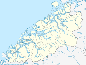 Åfarnes  Åfarnes Location in Møre og Romsdal | |
| Coordinates: 62°39′41″N 07°30′04″E / 62.66139°N 7.50111°ECoordinates: 62°39′41″N 07°30′04″E / 62.66139°N 7.50111°E | |
| Country | Norway |
| Region | Western Norway |
| County | Møre og Romsdal |
| District | Romsdal |
| Municipality | Rauma Municipality |
| Elevation[1] | 14 m (46 ft) |
| Time zone | CET (UTC+01:00) |
| • Summer (DST) | CEST (UTC+02:00) |
| Post Code | 6360 Åfarnes |
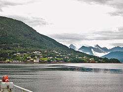
Åfarnes (historically, Aafarnes) is a village in Rauma Municipality in Møre og Romsdal county, Norway. The village is located at the confluence of the Romsdalsfjorden, Langfjorden, and Rødvenfjorden. The Norwegian County Road 64 runs through the village on its way from the town of Åndalsnes (to the south) and the town of Molde (to the north). There is a ferry quay in Åfarnes with regular ferries across the Langfjorden to the village of Sølsnes in Molde Municipality to the north. The proposed Langfjord Tunnel would connect Åfarnes and Sølsnes as part of County Road 64. The local Church of Norway parish is based at Holm Church, located about 4 kilometres (2.5 mi) east of the village.
References
This article is issued from Wikipedia - version of the 8/1/2016. The text is available under the Creative Commons Attribution/Share Alike but additional terms may apply for the media files.