Ñust'apata
| Ñust'apata | |
|---|---|
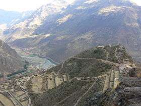 View of the Sacred Valley and the Willkanuta River in Písac. Ñustapata is in the background on the right. | |
| Highest point | |
| Elevation | 4,000 m (13,000 ft) [1] |
| Coordinates | 13°26′45″S 71°51′15″W / 13.44583°S 71.85417°WCoordinates: 13°26′45″S 71°51′15″W / 13.44583°S 71.85417°W [2] |
| Geography | |
 Ñust'apata Peru | |
| Location | Peru, Cusco Region |
| Parent range | Andes |
Ñust'apata (Quechua ñust'a princess, pata elevated place; above, at the top; edge, bank, shore, step)[3][4] "princess bank") is a mountain in the Cusco Region in Peru, about 4,000 metres (13,123 ft) high. It is situated in the Calca Province, on the border of the districts of Pisac and Taray. Ñust'apata lies on the left bank of the Willkanuta River, near the archaeological park of Pisac.[1]
References
- 1 2 escale.minedu.gob.pe - UGEL map of the Calca Province (Cusco Region) (unnamed)
- ↑ "Cerro Ñustapata". IGN, Peru. Retrieved July 6, 2015.
- ↑ Diccionario Quechua - Español - Quechua, Academía Mayor de la Lengua Quechua, Gobierno Regional Cusco, Cusco 2005 (Quechua-Spanish dictionary)
- ↑ Teofilo Laime Ajacopa, Diccionario Bilingüe Iskay simipi yuyayk'ancha, La Paz, 2007 (Quechua-Spanish dictionary)
This article is issued from Wikipedia - version of the 12/6/2015. The text is available under the Creative Commons Attribution/Share Alike but additional terms may apply for the media files.