Písac
| Písac P'isaq | |
|---|---|
| Town | |
|
Pisac and the Willkanuta River | |
 Písac | |
| Coordinates: 13°25′27″S 71°51′28″W / 13.42417°S 71.85778°W | |
| Country |
|
| Region | Cusco |
| Province | Calca |
| District | Pisac |
| Area | |
| • Total | 148.25 km2 (57.24 sq mi) |
| Elevation | 2,972 m (9,751 ft) |
| Population (2002) | |
| • Total | 9,796 |
| • Density | 66/km2 (170/sq mi) |
| Time zone | PET (UTC-5) |

Písac or Pisac (in hispanicized spellings) or P'isaq (Quechua for Nothoprocta, also spelled p'isaqa)[1] is a Peruvian village in the Sacred Valley. It is situated at the Willkanuta River. Pisac is most known for its Incan ruins and large market every Sunday, Tuesday, and Thursday, an event which attracts heavy tourist traffic from nearby Cusco.[2]
Notable Features
Pisac is perhaps best known for its Incan ruins, known as Inca Písac, which lie atop a hill at the entrance to the valley. The ruins are separated along the ridge into four groups: P'isaqa, Inti Watana, Qalla Q'asa, and Kinchiraqay.[3] Inti Watana group includes the Temple of the Sun, baths, altars, water fountains, a ceremonial platform, and an inti watana, a volcanic outcrop carved into a "hitching post for the Sun" (or Inti). The angles of its base suggest that it served to define the changes of the seasons.[4] Qalla Q'asa, which is built onto a natural spur and overlooks the valley, is known as the citadel.[5]
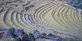
The Inca constructed agricultural terraces on the steep hillside, which are still in use today. They created the terraces by hauling richer topsoil by hand from the lower lands. The terraces enabled the production of surplus food, more than would normally be possible at altitudes as high as 11,000 feet.[6]
With military, religious, and agricultural structures, the site served at least a triple purpose. Researchers believe that Písac defended the southern entrance to the Sacred Valley, while Choquequirao defended the western entrance, and the fortress at Ollantaytambo the northern. Inca Pisac controlled a route which connected the Inca Empire with the border of the rain forest.
The sanctuary of Huanca, site of a sacred shrine, is also near the village. Pilgrims travel to the shrine every September.
One of its more notable features was a large pisonay tree, which dominated the central plaza (it was destroyed by a 2013 thunderstorm).[2]
History
According to the scholar Kim MacQuarrie, Pachacuti erected a number of royal estates to memorialize victories over other ethnic groups. Among these royal estates are Písac (victory over the Cuyos), Ollantaytambo (victory over the Tambos), and Machu Picchu (conquest of the Vilcabamba Valley).[7] Other historians suggest that Písac was established to protect Cusco from possible attacks of the Antis nations. It is unknown when Inca Písac was built. Since it does not appear to have been inhabited by any pre-Inca civilization, it was most likely built no earlier than 1440.
Francisco Pizarro and the Spanish conquerors destroyed Inca Písac in the early 1530s. The modern town of Písac was built in the valley by Viceroy Toledo during the 1570s.
Gallery
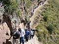 Footpath in Pisac
 Marketplace sells typical Andean crafts
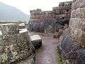 Inca structures in the urban sector of Pisac
 View from Qalla Q'asa to Andenes
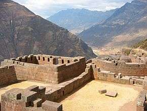
 Ruins
Ruins
See also
References
- ↑ Teofilo Laime Ajacopa, Diccionario Bilingüe Iskay simipi yuyayk'ancha, La Paz, 2007 (Quechua-Spanish dictionary)
- 1 2 "Pisac Market and ruins". Retrieved 2006-03-21.
- ↑ Box, Ben; Alan Murphy (2003-07-01). Footprint Peru Handbook. ISBN 1-903471-51-6.
- ↑ Elorrieta Salazar, Fernando E. & Elorrieta Salazar, Edgar (2005) Cusco and the Sacred Valley of the Incas, pages 69-75, ISBN 978-603-45-0911-5
- ↑ Jenkins, Dilwyn (2003-10-06). The Rough Guide to Peru. Rough Guides. ISBN 1-84353-074-0.
- ↑ Readers Digest: "Mysteries of the Ancient Americas: The New World before Columbus"
- ↑ MacQuarrie, Kim (2007-06-17). The last Days of the Incas. Simon & Schuster. ISBN 978-0-7432-6049-7.
External links
| Wikimedia Commons has media related to Pisac. |
Coordinates: 13°25′27″S 71°51′28″W / 13.42417°S 71.85778°W