Þingvellir
| Þingvellir National Park | |
|---|---|
|
IUCN category II (national park) | |
|
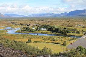
Þingvellir from the information centre overlook | |
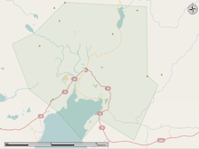
 Position of Þingvellir in Iceland | |
| Area | 9,270 ha |
| Established | 1930[1] |
| Type | Cultural |
| Criteria | iii, vi |
| Designated | 2004 (28th session) |
| Reference no. | 1152 |
| Region | Europe and North America (Northern Europe) |
Þingvellir (Icelandic: ![]() [ˈθiŋkˌvɛtlɪr̥] ), anglicised as Thingvellir,[Note 1] is a national park in the municipality of Bláskógabyggð in southwestern Iceland, about 40 km northeast of Reykjavík. Þingvellir is a site of historical, cultural, and geological importance and is one of the most popular tourist destinations in Iceland. It lies in a rift valley that marks the crest of the Mid-Atlantic Ridge and the boundary between the North American and Eurasian tectonic plates. To its south lies Þingvallavatn, the largest natural lake in Iceland.[2]
[ˈθiŋkˌvɛtlɪr̥] ), anglicised as Thingvellir,[Note 1] is a national park in the municipality of Bláskógabyggð in southwestern Iceland, about 40 km northeast of Reykjavík. Þingvellir is a site of historical, cultural, and geological importance and is one of the most popular tourist destinations in Iceland. It lies in a rift valley that marks the crest of the Mid-Atlantic Ridge and the boundary between the North American and Eurasian tectonic plates. To its south lies Þingvallavatn, the largest natural lake in Iceland.[2]
The Althing, the national parliament of Iceland, was established at Þingvellir in 930, and held its sessions there until 1798.[3] Þingvellir National Park (Icelandic: þjóðgarðurinn á Þingvöllum) was founded in 1930, marking the one-thousandth anniversary of the Althing. It was later expanded to protect natural phenomena in the surrounding area, and became a World Heritage Site in 2004.
Toponymy
The name Þingvellir is derived from the Old Norse Þingvǫllr, from þing (“thing, assembly”) and vǫllr (“field”), meaning assembly fields. Compare the English thing and weald (“Thingweald”) from Anglo-Saxon þing and weald. The site takes its name from Alþing (Althing), the national parliament of Iceland, which was founded at Þingvellir in 930 and held its sessions there until 1798. A thing was a form of governing assembly found in Germanic societies, and a tradition that endures to this day in one form or another across Northern Europe.
Although the name Þingvellir is plural, the older form Þingvǫllr is singular, and the modern singular form Þingvöllur can still be heard.
The name is anglicised as Thingvellir, and might appear as Tingvellir, Thingvalla or Tingvalla in other languages. The spelling Pingvellir is wrong as the letter “p” should never be used to represent the letter “þ” (thorn).
Dingwall and Tingwall in Scotland, Thingwall in England, Tynwald on the Isle of Man, and Tingvoll in Norway bear names of the same root and meaning.
History
Þingvellir became a national park as a result of legislation passed in 1928 to protect the remains of the parliament site by creating the first national park in Iceland, decreed "a protected national shrine for all Icelanders, the perpetual property of the Icelandic nation under the preservation of parliament, never to be sold or mortgaged."[4]
Founding of Iceland's parliament
According to the Book of Settlements (Landnámabók), the settlement of Iceland began in AD 874 when the Norwegian chieftain Ingólfur Arnarson became the first permanent Norwegian settler on the island.[5][6] Over the next centuries, people of Norse and Celtic origin settled in Iceland. Early on, district assemblies were formed, but as the population grew, there was a need for a general assembly. The descendants of Ingólfur who dominated the region of southwest Iceland had become the most powerful family in the country, and other chieftains felt a need for a general assembly to limit their power.
Grímur Geitskör was allotted the role of rallying support and finding a suitable location for the assembly. At about the same time, the owner of Bláskógar (the contemporary name for the Þingvellir region) was found guilty of murder and his land was declared public and obligated to be used for assembly proceedings, the building of temporary dwellings, the use of the forest for kindling and the grazing of horses. The Þingvellir area was chosen for this reason and for its accessibility from the most populous regions of the north, south and west.[7] The longest journey a goði (chieftain) had to travel was 17 days, from the easternmost part of the country where mountains and glacial rivers proved bothersome obstacles.[3]
The foundation of the Icelandic parliament is said to be the founding of the nation of Iceland, and the first parliamentary proceedings in the summer of 930 laid the ground for a common cultural heritage and national identity. Þingvellir played a central role in the history of the country, and its history runs almost parallel with the history of the Icelandic Commonwealth.


From commonwealth to foreign rule
The Alþingi (assembly) at Þingvellir was Iceland's supreme legislative and judicial authority from its establishment in 930 until 1271. The Lögberg (Law Rock) was the focal point of the Alþingi and a natural platform for holding speeches. The Lawspeaker, elected for three years at a time, presided over the assembly and recited the law of the land. Before the law was written down, he was expected to recite it from memory on the Lögberg over the course of three summers along with the complete assembly procedures every summer. Inauguration and dissolution of the assembly took place at the Lögberg, where rulings made by the Law Council were announced, the calendar was confirmed, legal actions were brought and other announcements made which concerned the entire nation. Anyone attending the assembly was entitled to present his case on important issues from the Lögberg.
The Law Council served as both parliament and supreme court. Laws were passed and approved there, and rulings made on points of law. The Law Council appointed members of the Fifth Court (a kind of appellate court) and the Lawspeaker, and took part in the election of the bishop. Unlike the Alþingi, the Law Council was a closed body in which only certain people enjoyed full rights: chieftains who held the office of "goði", their "Þingmen" and later also bishops. However, everyone at the assembly was entitled to watch and listen to the Law Council at work.
From the earliest times until the 15th century, the Law Council met at Neðri-Vellir on the east bank of Öxará, but when the river changed its course around 1500, the council was moved to an islet in the river. In 1594, the Law Council was relocated to the foot of the ancient Law Rock, where it remained until the Alþingi was finally transferred from it in 1798.
The Alþingi was Iceland's legislative and chief judicial authority for the duration of the Commonwealth, until 1271. Executive power was in the hands of the chieftains and parties to individual cases. This proved to be quite an adequate arrangement for as long as the balance of power remained, but flaws emerged when it was disrupted. In the final decades of the Commonwealth, there were clashes between chieftain families, which resulted in Iceland coming under the Norwegian crown. Executive power was strengthened under this new order, while legislative and judicial authority remained in the hands of the Alþingi but was gradually transferred to the Norwegian and later Danish rulers until the King of Denmark became an absolute monarch of Iceland in 1662.
Social centre
Þingvellir was the centre of Icelandic culture. Every year during the Commonwealth period, people would flock to Þingvellir from all over the country, sometimes numbering in the thousands. They set up dwellings with walls of turf and rock and temporary roofing and stayed in them for the two weeks of the assembly. Although the duties of the assembly were the main reason for going there, ordinary people gathered at Þingvellir for a wide variety of reasons. Merchants, sword-sharpeners, and tanners would sell their goods and services, entertainers performed, and ale-makers brewed drinks for the assembly guests. News was told from distant parts; games and feasts were held. Young people met to make their plans, no less than leading national figures and experts in law. Itinerant farmhands looked for work and vagrants begged. Þingvellir was a meeting place for everyone in Iceland, laying the foundation for the language and literature that have been a prominent part of people's lives right up to the present day.
Geography
Þingvellir is notable for its unusual tectonic and volcanic environment in a rift valley.
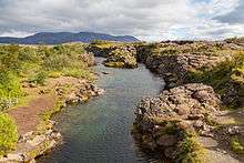
The continental drift between the North American and Eurasian Plates can be clearly seen in the cracks or faults which traverse the region, the largest one, Almannagjá, being a veritable canyon. This also causes the often measurable earthquakes in the area.[8]
Some of the rifts are full of clear water. One, Nikulásargjá, is better known as Peningagjá (lit. "coin fissure"), as its bottom is littered with coins. After being bridged in 1907 for the occasion of the visit of King Frederick VIII of Denmark, visitors began to throw coins in the fissure, a tradition based on European legends.
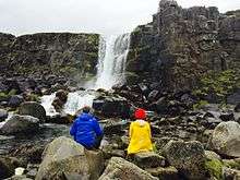
Þingvellir is situated on the northern shore of Þingvallavatn, the largest natural lake of Iceland. The river Öxará traverses the national park and forms a waterfall at the Almannagjá, called Öxarárfoss. On the lake's northern shore the Silfra fissure is a popular diving and snorkelling tour location.
Þingvellir was designated a UNESCO World Heritage Site on cultural criteria. It may also qualify on geological criteria in the future, as there has been ongoing discussion of a possible "serial trans-boundary nomination" for the Mid-Atlantic Ridge, which would include other sites in the Atlantic such as Pico Island.[9]
Together with the waterfall Gullfoss and the geysers of Haukadalur, Þingvellir is part of a group of the most famous sights of Iceland, the Golden Circle.
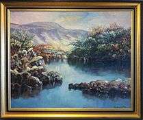
Art
Because of its natural beauty, Þingvellir has been a notable subject in the works of the most famous Icelandic painters, including Johannes Sveinsson Kjarval and Ásgrímur Jónsson. The National gallery of Iceland owns more than 150 paintings by Ásgrímur Jónsson where the subject is Þingvellir. The place grew popular among painters that lacked monetary funds to travel because Þingvellir is close to the capital of Iceland, Reykjavík, and it was relatively cheap to travel there.
Tourism
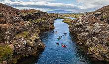
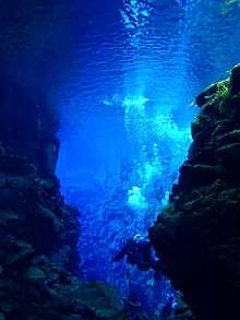
Þingvellir National Park is popular with tourists, and is one of the three key attractions within the Golden Circle. There is a visitor centre, where visitors can obtain interpretation of the history and nature of Þingvellir.[10] There is an information centre near the camping grounds.[11] There are hiking trails. Scuba diving has also become popular at Silfra Lake as the continental drift between the tectonic plates made it wide enough for divers to enjoy unparalleled visibility.
Related places
Culturally related places
Things (assemblies)
- Gulating, one of the first Norwegian legislative assemblies and one of the present-day law courts of western Norway.
- Jamtamót, the historical legislative assembly of Jämtland.
- Løgting, the parliament of the Faroe Islands and Tinganes, the site of the Faroese government.
- Tynwald, the legislature of the Isle of Man. Tynwald shares the root and meaning of its name with Þingvellir.
Cognate toponyms
- Dingwall, a royal burgh in the Scottish Highlands.
- Thingwall, a village in Wirral, England.
- Tingwall, a parish in Shetland.
- Tingvoll, a town in Norway.
- Thingvalla Township in the U.S. state of North Dakota, one of that state's earliest Icelandic settlements,[12] was named in honor of Þingvellir.[13]
Geologically related places
- Gough and Inaccessible Islands in the South Atlantic.
- Pico Island in the Azores.
Trivia
- The Thingvalla Line, a Danish shipping company active between 1879 and 1898, was named after Þingvellir. At its peak, the company had ten ships in its fleet, one of which was named the S/S Thingvalla, launched in 1873. The company operated four other ships which bore Icelandic names, namely the S/S Geiser, the S/S Island and two vessels named S/S Hekla.[14]
See also
- Crymostygius thingvallensis, a species of subterranean amphipod crustacean, endemic to the area around Þingvallavatn.
Notes and references
Notes
- ↑ The spelling Pingvellir is wrong as the letter “p” should never be used to represent the letter “þ” (thorn).
References
- 1 2 "National Park History". Retrieved 18 January 2015.
- ↑ Geology and Tectonics
- 1 2 Björnsson, Björn Th. Þingvellir. Reykjavík: Bókaútgáfa Menningarsjóðs, 1984.
- ↑ Lagasafn. Lög um þjóðgarðinn á Þingvöllum, 2004 nr. 47 1. júní, 1.gr.
- ↑ Tomasson, Richard F. (1980). Iceland, the first new society. University of Minnesota Press. ISBN 0-8166-0913-6.
- ↑ I. Marc Carlson. "History of Medieval Greenland". Personal.utulsa.edu. Retrieved 2010-02-10.
- ↑ Jónsson, Bergsteinn; Þorsteinsson, Björn. Íslands Saga til okkar daga. Reykjavík: Sögufélag, 1991
- ↑ "Earthquakes: Iceland". Icelandic Meteorological Office. Retrieved 2008-10-05.
- ↑ "Mid-Atlantic Ridge". Retrieved 19 January 2015.
- ↑ "Visitor Centre". Retrieved 9 February 2015.
- ↑ "Information Centre". Retrieved 10 February 2015.
- ↑ Johnson, Sveinbjorn (1906). Libby, Orin Grant, ed. The Icelandic Settlement of Pembina County. Collections of the State Historical Society of North Dakota. 1. Bismarck, ND: Tribune, State Printers and Binders. p. 109. OCLC 01773487.
- ↑ "Thingvalla History (Thingvalla Lutheran Church Memorial)". thingvalla.org. Retrieved 2010-07-02.
- ↑ "The Thingvalla Line". NorwayHeritage.com. Retrieved 21 July 2016.
External links
| Wikimedia Commons has media related to Þingvellir. |
| Wikivoyage has a travel guide for Þingvellir National Park. |
- Official website
- UNESCO World Heritage listing
- Photos from Þingvellir at ICELANDPHOTOBLOG.COM
- Photogallery by islandsmyndir.is
- Photo
- Andy Carvin's Thingvellir Gallery
- Photos from www.icelandportfolio.com
- Scuba Diving in between the continents in Thingvellir National Park
| Current | ||
|---|---|---|
| Former | ||
Coordinates: 64°15′29″N 21°07′30″W / 64.25806°N 21.12500°W