Świecie
| Świecie Świecie nad Wisłą | |||
|---|---|---|---|
|
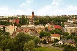
Town view from the Teutonic castle tower | |||
| |||
|
Motto: Świecie - najlepsze na świecie Świecie - the best in the world | |||
 Świecie | |||
| Coordinates: 53°25′N 18°26′E / 53.417°N 18.433°ECoordinates: 53°25′N 18°26′E / 53.417°N 18.433°E | |||
| Country |
| ||
| Voivodeship | Kuyavian-Pomeranian | ||
| County | Świecie County | ||
| Gmina | Gmina Świecie | ||
| Established | 1198 | ||
| Town rights | 1338 | ||
| Government | |||
| • Mayor | Tadeusz Grzegorz Pogoda | ||
| Area | |||
| • Total | 11.87 km2 (4.58 sq mi) | ||
| Highest elevation | 86 m (282 ft) | ||
| Lowest elevation | 19 m (62 ft) | ||
| Population (2006) | |||
| • Total | 25,614 | ||
| • Density | 2,200/km2 (5,600/sq mi) | ||
| Time zone | CET (UTC+1) | ||
| • Summer (DST) | CEST (UTC+2) | ||
| Postal code | 86-100 to 86-105 | ||
| Area code(s) | +48 52 | ||
| Car plates | CSW | ||
| Website |
www | ||


Świecie pronounced [ˈɕfjɛt͡ɕɛ] (German: Schwetz) is a town in northern Poland with 25,968 inhabitants (2006), situated in Kuyavian-Pomeranian Voivodeship (since 1999); it was in Bydgoszcz Voivodeship from 1975 to 1998. It is the capital of Świecie County.
Location
Świecie is located on the west bank of river Vistula at the mouth of river Wda, approximately 40 kilometres (25 mi) north-east of Bydgoszcz, 105 kilometers south of Gdańsk and 190 kilometers south-west of Kaliningrad.
History
Świecie became the residence of Pomeranian Duke Grimislaw, when in 1198 the St. Mary's church was erected there. Grimislaw's Duchy of Pomerania included prominent towns of Starogard Gdański and Lubiszewo Tczewskie, as well as Skarszewy with its surrounding region. The Teutonic Order conquered Gdańsk in 1309 and in 1310 bought Pomeralia in Soldin from the Margraves of Brandenburg. By then, the settlement already had the status of Civitas, just as Gdańsk and Tczew did. Świecie was granted a municipal form of government by the Teutonic Order, when it was still located on the high west bank of the Vistula. Probably because of destruction by fire, during the period 1338–1375 the town was relocated down into the valley at the Vistula. After the Thirteen Years' War (1454–66) Świecie became part of the autonomous province of Royal Prussia incorporated into the Kingdom of Poland. In 1772, during the Partitions of Poland, the town was annexed by the Kingdom of Prussia, and Schwetz was integrated into the newly formed Province of West Prussia. In 1905 the town had a Protestant church, two Catholic churches and a synagogue.[1] After World War I Świecie became part of the Pomeranian Voivodeship with the provincial capital in Toruń of the Second Republic of Poland.[2]
During the Second World War, Nazi Germany occupied Świecie and annexed it on 8 October 1939, making it the seat of the Kreis county of Schwetz. It was administered as part of Reichsgau Danzig-West Prussia. Prominent Poles were arrested using secret politically targeted hit list and murdered using the Volksdeutscher Selbstschutz paramilitaries.[3]
People shot were finished off by blows delivered by shovels and the butts of assault rifles; they were buried in mass graves when still alive. Mothers were forced to place their children in the pits where they were shot together. Before executions women and girls were raped.(...) [The atrocities] evoked horror even in the Germans, including some soldiers. Terrified at what they saw in the town of Świecie two of them felt compelled to submit a report [to military authorities].[3]
After the defeat of Adolf Hitler in World War II Świecie became part of the Bydgoszcz Voivodeship formed in 1946 in the People's Republic of Poland. The town grew rapidly with population reaching 13,500 by 1961. Sugar refinery was expanded, meat, cattle feed plants, and mills were built, including the paper factory launched in 1968, with 4,600 employees.[4]
Demographics
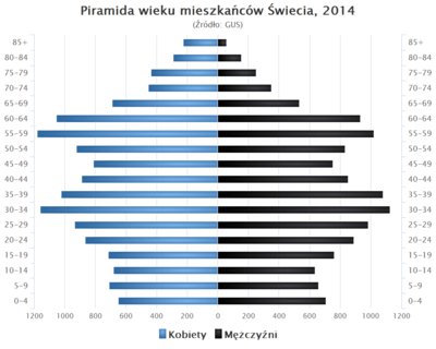
|
Above table is based on primary, potentially biased, sources.[6][7][8][9][9] |
Major corporations
- Mondi Świecie SA (before, known as Mondi Packaging Paper Świecie SA, and Frantschach Świecie SA as well as Celuloza Świecie SA) – paper products and packaging
Education
- Wyższa Szkoła Menedżerska (Higher School of Management)
- I LO im. Floriana Ceynowy
- II LO w Świeciu
- Zespół Szkół Ponadgimnazjalnych
Sport
- Wda Świecie football club
- Polpak Świecie basketball team
Notable personalities
- Heinrich von Plauen (the Elder) (ca. 1370–1429), 27th grand master of the Teutonic Order
- Günther Radusch (1912-1988), Luftwaffe pilot
- Aleksy Kuziemski, professional boxer
- Janusz Józefowicz, director, choreographer, creator of Metro (musical)
- Dawid Konarski, volleyball player with ZAKSA Kędzierzyn-Koźle
| Wikimedia Commons has media related to Świecie. |
Footnotes
- ↑ Meyers Konversations-Lexikon, 6th edition, Vol. 18, Leipzig and Vienne 1909, p. 210.
- ↑ Krzysztof Halicki: Szkice z dziejów Świecia nad Wisłą i powiatu w dwudziestoleciu międzywojennym, Toruń 2012, s. 212. – Academia.edu.
- 1 2 Konrad Ciechanowski (2006). "Oboz dla Jencow Cywilnych (Zivilgefangenenlager)" [Internment of Civilian Prisoners]. Obozy Podlegle Organom Policyjnym (Monografia KL STUTTHOF. Chapter 2). Stutthof Museum (Państwowe Muzeum Stutthof w Sztutowie). Archived from the original on October 29, 2007. Retrieved 20 May 2014.
Translation from Polish: Rozstrzeliwanych dobijano łopatami, kolbami, a niekiedy zakopywano jeszcze żywych. Matki zmuszano do układania w wykopanych dołach swoich dzieci, a potem je same rozstrzeliwano. Przed rozstrzelaniem gwałcono dziewczęta i kobiety.
- ↑ Urząd Miejski w Świeciu, Historia Świecia ( Świecie history). Official website.
- ↑ GUS, Dane demograficzne. Swiecie.
- ↑ Johann Friedrich Goldbeck: Vollständige Topographie des Königreichs Preußen. Teil II, Marienwerder 1789, p. 72, no 3.
- ↑ August Eduard Preuß: Preußische Landes- und Volkskunde. Königsberg 1835, p. 386.
- ↑ Friedrich Christoph Förster: Statistisch-topographisch-historische Uebersicht des Preußischen Staats, Berlin and Leipzig 1838, p. 96.
- 1 2 Michael Rademacher: Deutsche Verwaltungsgeschichte Provinz Westpreußen, Kreis Schwetz (2006).
Seat: Świecie | ||
| Urban-rural gminas |  | |
| Rural gminas | ||