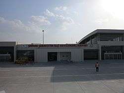
Şırnak Airport
| Şırnak Şerafettin Elçi Airport Şırnak Şerafettin Elçi Havalimanı | |||||||||||
|---|---|---|---|---|---|---|---|---|---|---|---|
 | |||||||||||
| IATA: NKT – ICAO: LTCV | |||||||||||
| Summary | |||||||||||
| Airport type | Public | ||||||||||
| Owner | DHMI | ||||||||||
| Operator | State Airports Administration (Turkish: Devlet Hava Meydanları İşletmesi (DHMİ)) | ||||||||||
| Serves | Sirnak | ||||||||||
| Location | Cizre - Idil | ||||||||||
| Elevation AMSL | 2,038 ft / 621 m | ||||||||||
| Coordinates | 37°21′50″N 42°03′36″E / 37.36389°N 42.06000°E | ||||||||||
| Website | http://sirnak.dhmi.gov.tr/ | ||||||||||
| Map | |||||||||||
 NKT Location of airport in Turkey | |||||||||||
| Runways | |||||||||||
| |||||||||||
Şırnak Şerafettin Elçi Airport (IATA: NKT, ICAO: LTCV) (Turkish: Şırnak Şerafettin Elçi Havalimanı) is a public airport near Cizre, a town in Şırnak Province, Turkey. The airport was opened to public/civil air traffic on 26.July.2013, the airport is 60 km (37 mi) away from Şırnak town centre.[1] It is named in honor of native politician Şerafettin Elçi (1938-2012).[2]
Airlines and destinations
| Airlines | Destinations |
|---|---|
| Turkish Airlines | Istanbul-Atatürk |
| Turkish Airlines operated by AnadoluJet | Ankara, Istanbul-Sabiha Gökcen |
External links
- http://www.ucuyorum.com/showthread.php?577-ÅIRNAK-Havaalanı-Projesi/page3
- http://www.dhmi.gov.tr/haberler.aspx?HaberID=1729
- http://www.hurriyetdailynews.com/sirnak-airport-set-to-open-in-four-months.aspx?pageID=238&nid=27310
- http://siyaset.milliyet.com.tr/baris-elci-si-havaalani/siyaset/detay/1736046/default.htm?ref=OtherNews
References
- ↑ (Turkish)
- ↑ "Bu ismi herkes veremezdi". Sabah (in Turkish). 2013-07-14. Retrieved 2013-07-15.
This article is issued from Wikipedia - version of the 11/27/2016. The text is available under the Creative Commons Attribution/Share Alike but additional terms may apply for the media files.