Žemaitija National Park
| Žemaitija National Park | |
|---|---|
|
IUCN category II (national park) | |
|
Plateliai lake | |
| Location | Lithuania |
| Coordinates | 56°02′38″N 21°53′20″E / 56.044°N 21.889°ECoordinates: 56°02′38″N 21°53′20″E / 56.044°N 21.889°E |
| Area | 217.20 km² |
| Established | 1991 |
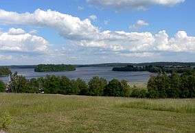
Žemaitija National Park is a national park in Lithuania. It is situated on Žemaičių Highlands, 45 km from the Baltic Sea. Lakes cover more than 7% of its territory. Lake Plateliai (12.05 km², 47 m depth) is the largest lake. The town of Plateliai, situated on the shore of the lake, is the seat of the park's administration and a popular tourist destination.
See also

The underground R-12U nuclear missile launching silo in Plokštinė base
This article is issued from Wikipedia - version of the 11/5/2016. The text is available under the Creative Commons Attribution/Share Alike but additional terms may apply for the media files.