1855 Atlantic hurricane season
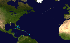 | |
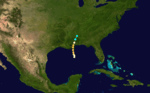
| Season summary map | |
| First system formed | August 5, 1855 |
|---|---|
| Last system dissipated | September 17, 1855 |
| Strongest storm1 | Five – 125 mph (205 km/h) (1-minute sustained) |
| Total storms | 5 |
| Hurricanes | 4 |
| Major hurricanes (Cat. 3+) | 1 |
| Total fatalities | Unknown |
| Total damage | Unknown |
| 1Strongest storm is determined by lowest pressure | |
1853, 1854, 1855, 1856, 1857 | |
The 1855 Atlantic hurricane season featured tropical cyclone landfalls in the Gulf Coast of the United States, the Greater Antilles, and Mexico, but none along the East Coast of the United States. It was inactive, with only five known tropical cyclones. Operationally, another tropical storm was believed to have existed offshore Atlantic Canada in late August and early September,[1] but HURDAT – the official Atlantic hurricane database – now excludes this system.[2] The first system, Hurricane One, was initially observed on August 6. The final storm, Hurricane Five, was last observed on September 17. These dates fall within the period with the most tropical cyclone activity in the Atlantic. At one point during the season, two tropical cyclones existed simultaneously. Two of the cyclones only have a single known point in their tracks due to a sparsity of data, so storm summaries for those systems are unavailable.
Of the season's five tropical cyclones, four reached hurricane status. Furthermore, one of those four strengthened into a major hurricane, which are Category 3 or higher on the modern-day Saffir–Simpson hurricane wind scale. The strongest cyclone of the season, Hurricane Five, peaked at Category 3 strength with 125 mph (205 km/h) winds. It brought only minor impact to Louisiana and Mississippi. The first storm of the season brought locally severe impact to Tampico, Tamaulipas, Mexico in early August. Tropical Storm Four caused severe damage in the Lesser Antilles.
The season's activity was reflected with a low accumulated cyclone energy (ACE) rating of 18. This was the lowest value on record until a rating of 13 during the 1907 season.[3] ACE is, broadly speaking, a measure of the power of the hurricane multiplied by the length of time it existed, so storms that last a long time, as well as particularly strong hurricanes, have high ACEs. ACE is only calculated for full advisories on tropical systems at or exceeding 34 knots (39 mph, 63 km/h) or tropical storm strength.[4]
Storms
Hurricane One
| Category 2 hurricane (SSHWS) | |||
|---|---|---|---|
| |||
| Duration | August 6 – August 6 | ||
| Peak intensity | 105 mph (165 km/h) (1-min) | ||
Based on newspaper reports,[5] the first hurricane of the season was within the vicinity of Tampico, Tamaulipas on August 6. Maximum sustained winds were at 105 mph (165 km/h), indicating a Category 2 hurricane.[2] No further information is available on the meteorological history of this storm. However, it is possible that the storm developed in the Caribbean Sea in late July, due to data obtained from the barque Bercaldine.[1] Torrential rainfall in the Tampico area caused disastrous flooding, with heavy damage to goods and property. Eleven vessels were docked at Tampico, some of which lost their cargo. At the mouth of the Pánuco River, a pilot station and a fort were swept away. The event was considered "the worst inundation of Tampico over the last 30 years".[5]
Hurricane Two
| Category 2 hurricane (SSHWS) | |||
|---|---|---|---|
| |||
| Duration | August 10 – August 11 | ||
| Peak intensity | 105 mph (165 km/h) (1-min) | ||

The ship James Foster Jr. encountered a hurricane on August 10, while located about 575 miles (925 km) east-southeast of Cape Race, Newfoundland. Sustained winds of 105 mph (165 km/h) were observed, equivalent to a Category 2 hurricane. Data from the James Foster Jr. and Rebecca indicate that the storm moved rapidly northeastward. This system was last noted about 560 miles (900 km) west of Ireland on August 11.[1][2]
Hurricane Three
| Category 1 hurricane (SSHWS) | |||
|---|---|---|---|
| |||
| Duration | August 11 – August 11 | ||
| Peak intensity | 80 mph (130 km/h) (1-min) | ||
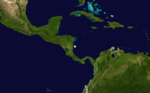
The HMS Walverine reported a hurricane at 12.5°N, 83.0°W, which is located about 15 miles (24 km) north of Corn Islands, Nicaragua.[1] A sustained wind speed of 80 mph (130 km/h) was observed.[2] Shortly thereafter, the HMS Walverine was wrecked and no further information is known about this storm.[1]
Tropical Storm Four
| Tropical storm (SSHWS) | |||
|---|---|---|---|
| |||
| Duration | August 24 – August 27 | ||
| Peak intensity | 70 mph (110 km/h) (1-min) 997 mbar (hPa) | ||
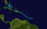
Based on reports of a strong gale, a tropical storm was first tracked about 250 miles (400 km) east-southeast of Barbados early on August 24.[1] It initially headed westward, before re-curving west-northwestward early on the following day. Shortly thereafter, the storm passed through the Windward Islands between Grenada and Saint Vincent and the Grenadines. The storm peaked with winds of 70 mph (110 km/h) while moving northwestward across the Caribbean Sea. It weakened slightly before making landfall near San Pedro de Macorís, Dominican Republic with winds of 60 mph (95 km/h) early on August 27. The storm slowly weakened over Hispaniola and was last noted near Bombardopolis, Haiti later that day.[2]
There was considerable damage in the Lesser Antilles. On Saint Vincent, rains destroyed roads and a number of houses. Many sugar cane fields were also ruined. Several vessels were lost there and on other islands, including Barbados, Dominica, and Martinique. On Saint Croix in the present-day U.S. Virgin Islands, at least one vessel was destroyed by the heavy gales. There were also strong gales reported in Puerto Rico and Dominican Republic.[1]
Hurricane Five
| Category 3 hurricane (SSHWS) | |||
|---|---|---|---|
| |||
| Duration | September 15 – September 17 | ||
| Peak intensity | 125 mph (205 km/h) (1-min) | ||
The ship Orphan encountered a hurricane with winds of 80 mph (130 km/h) in the central Gulf of Mexico on September 15.[6] It strengthened quickly while moving northward, becoming a Category 2 hurricane later that day. By 0000 UTC on September 16, the storm peaked as a Category 3 hurricane with maximum sustained winds of 125 mph (205 km/h), making it the strongest tropical cyclone of the season. Shortly thereafter, the hurricane made landfall near Buras-Triumph, Louisiana at the same intensity. It weakened after moving inland, decreasing to Category 1 intensity later on September 16. Early on the following day, the system weakened to a tropical storm, several hours before dissipating over central Alabama.[2]
This was regarded as the worst hurricane in the region since 1819. In Louisiana, winds and storm surge impacted the eastern portions of the state. The wharf and bathhouse in Proctorville were swept away. About 4 feet (1.2 m) of water was reported at Proctor's Landing. A combination of strong winds and storm surge destroyed a number of houses along the shores of Lake Borgne. Along the coast of Mississippi, most structures were swept to sea.[7] The foundation of the Biloxi Lightouse was endangered due to erosion from this storm.[8] The Cat Island Lighthouse was also left in "severe peril". Several ships were damaged or capsized in the Mississippi River, including the Atchafalaya, J.S. Chenoweth, Ship Shoal, and Venice.[7]
Other storms
In addition to the five tropical systems, another storm was operationally believed to have existed in late August and early September. The ship Atlantic encountered a very heavy gale while located west of Sable Island, Nova Scotia on August 31. The storm moved rapidly east-northeastward offshore Atlantic Canada. It was last noted on September 2 and was thought to have transitioned into an extratropical cyclone.[1] However, HURDAT no longer includes this system in its database.[2]
See also
References
- 1 2 3 4 5 6 7 8 Jose F. Partagas (1996). Year 1855 (PDF). Atlantic Oceanographic and Meteorological Laboratory (Report). Miami, Florida: National Oceanic and Atmospheric Administration. pp. 32–36. Retrieved July 1, 2013.
- 1 2 3 4 5 6 7 National Hurricane Center; Hurricane Research Division (July 6, 2016). "Atlantic hurricane best track (HURDAT version 2)". United States National Oceanic and Atmospheric Administration. Retrieved December 5, 2016.
- ↑ Atlantic basin Comparison of Original and Revised HURDAT. Hurricane Research Division (Report). National Oceanic and Atmospheric Administration. March 2011. Retrieved July 1, 2013.
- ↑ David Levinson (August 20, 2008). 2005 Atlantic Ocean Tropical Cyclones. National Climatic Data Center (Report). National Oceanic and Atmospheric Administration. Retrieved July 1, 2013.
- 1 2 "Destructive Storm at Tampico". The New York Times. The Times-Picayune. August 20, 1855. Retrieved August 12, 2013.
- ↑ "Marine Intelligence". The New York Times. October 3, 1855. Retrieved August 12, 2013.
- 1 2 David M. Roth (April 8, 2010). Louisiana Hurricane History (PDF). Weather Prediction Center (Report). National Oceanic and Atmospheric Administration. p. 17. Retrieved July 1, 2013.
- ↑ Charles S. Sullivan (1986). Hurricanes of the Mississippi Gulf Coast: 1717 to Present. Gulf Publishing Company, Inc. p. 21.