1863 Atlantic hurricane season
| |
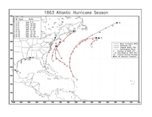
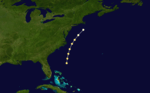
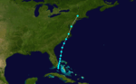
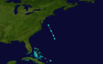
| Season summary map |
| First storm formed |
May 24, 1863 |
| Last storm dissipated |
September 30, 1863 |
| Strongest storm |
One, Two, Three, and Four |
| Total storms |
9 |
| Major storms (Cat. 3+) |
0 |
| Total damage |
$1+ million (1867 USD) |
| Total fatalities |
90 |
Atlantic hurricane seasons
1861, 1862, 1863, 1864, 1865 |
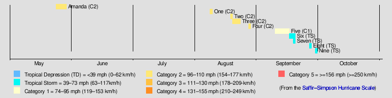
The 1863 Atlantic hurricane season ran through the summer and fall of 1863 and comprised four tropical storms and five hurricanes, none of which became major hurricanes, (Category 3+). However, in the absence of modern satellite and other remote-sensing technologies, only storms that affected populated land areas or encountered ships at sea were recorded, so the actual total could be higher. An undercount bias of zero to six tropical cyclones per year between 1851 and 1885 and zero to four per year between 1886 and 1910 has been estimated.[1] Of the known 1863 cyclones, seven were first documented in 1995 by Jose Fernandez-Partagas and Henry Diaz.[2] Tropical Storm Nine was first documented in 2003.[3] One hurricane intensified to near major hurricane status and made landfall in northwest Florida on May 28, 1863; making it one of the earliest landfalls in the North Atlantic basin.[4]
Timeline
Storms
Hurricane One
| Category 2 hurricane (SSHWS) |
|
|
| Duration |
August 8 – August 9 |
| Peak intensity |
105 mph (165 km/h) (1-min) |
A Category 2 hurricane is known to have travelled on a northeasterly course off Novia Scotia throughout August 8 and 9. The hurricane is known from reports from three ships, including the Ashburton.[2]
Hurricane Two
| Category 2 hurricane (SSHWS) |
|
|
| Duration |
August 18 – August 19 |
| Peak intensity |
105 mph (165 km/h) (1-min) |
During August 18 and 19, a Category 2 hurricane, moving on an east-northeast track, is known to have existed off the coast of Novia Scotia. It caused the loss of the ship B.R. Millam, whose crew transferred to the Thebes, and caused the Herzogin to lose several masts and sails. The ship American Congress also encountered the hurricane throughout August 18.[2]
Hurricane Three
| Category 2 hurricane (SSHWS) |
|
|
| Duration |
August 19 – August 23 |
| Peak intensity |
105 mph (165 km/h) (1-min) 975 mbar (hPa) |
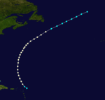
A hurricane was first seen on August 19 in the western Atlantic, midway between the southeastern Bahamas and Bermuda. It headed northwestward, causing heavy rains and damage to the Outer Banks but remained offshore. It turned northeastward, hitting the south coast of Nova Scotia before losing its tropical characteristics on August 23rd. Several vessels were struck by the hurricane. The US brig Bainbridge capsized in the storm off Hatteras early on August 21 with the loss of eighty lives.[5] The sole survivor was picked up by the South Boston on the evening of August 22. The ship American Congress encountered this hurricane on August 22 off Georges Bank. On August 23 the Minor was wrecked on the south side of St Paul Island, off the northeastern tip of Nova Scotia. Two ships, including the Ashburton recorded barometer readings of 28.80 inches during the storm.[2]
Hurricane Four
| Category 2 hurricane (SSHWS) |
|
|
| Duration |
August 27 – August 28 |
| Peak intensity |
105 mph (165 km/h) (1-min) |
This hurricane is known from two ship reports. The steamship Dolphin, sailing from Key West to New York, encountered a hurricane on the night of August 27 and throughout the morning of August 28. The brig Camilla was struck 200 miles from Sandy Hook on August 28 and forced to return to port for repairs.[2]
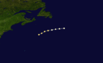
Hurricane Five
| Category 1 hurricane (SSHWS) |
|
|
| Duration |
September 9 – September 16 |
| Peak intensity |
80 mph (130 km/h) (1-min) |
A tropical storm formed on September 9 to the northeast of the Bahamas. It tracked to the northwest before becoming a hurricane the next day and curving north. The hurricane never made a landfall and is only known from ship reports. The first ship known to have encountered the hurricane was the brigantine Frank W. on the night of September 8 and the morning of September 9. Also on September 9, the Mary Ann was dismasted. At Bermuda at least three ships docked which had sustained damage in the hurricane off the southeast end of the island on September 11. Further north, the bark Machae was dismasted on September 14. The hurricane dissipated to the northeast of Newfoundland on September 16.[2]
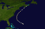
Tropical Storm Six
| Tropical storm (SSHWS) |
|
|
| Duration |
September 16 – September 19 |
| Peak intensity |
70 mph (110 km/h) (1-min) |
A tropical storm formed near south Florida on September 16. The same day it dismasted the sloop Eliza at Matanilla Reef, about 50 mi (80 km) north of Grand Bahama. Moving north the storm was offshore of Charleston and Wilmington throughout September 17 and 18. On September 18 two schooners were capsized in the Lower Potomac, crops were destroyed in the area and a railroad bridge was carried away. A ship was demasted off Cove Point, Chesapeake Bay on September 18 and gale force winds were recorded at New York harbour the same day.[2]
Tropical Storm Seven
| Tropical storm (SSHWS) |
|
|
| Duration |
September 18 – September 19 |
| Peak intensity |
60 mph (95 km/h) (1-min) |
On September 18 a heavy northern gale wrecked the ship Smoker on the bar at Tampico, Mexico. On September 19 two ships, the John Howell and the J.K.L were wrecked, the latter with the loss of ten lives, whilst loading in the Gulf of Mexico. No specific locations are known for these shipwrecks so no track for this storm is known, other than it was active in the western Gulf of Mexico on September 18 and 19.[2]
Tropical Storm Eight
| Tropical storm (SSHWS) |
|
|
| Duration |
September 26 – September 27 |
| Peak intensity |
60 mph (95 km/h) (1-min) |
Three ships reported encountering a tropical storm on September 26 in the western Atlantic. Their respective positions give the storm a track west of north towards the coast of Virginia.[2]
Tropical Storm Nine
| Tropical storm (SSHWS) |
|
|
| Duration |
September 29 – September 30 |
| Peak intensity |
70 mph (110 km/h) (1-min) 999 mbar (hPa) |
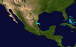
A tropical storm passed offshore of southeast Texas on September 28 and 29. Later on September 29 it made landfall in southwest Louisiana. High winds and tree damage were seen at Sabine Pass where the schooner Manhasett was driven ashore. The storm became extratropical as it moved across Louisiana. The rain the storm brought to New Orleans ended a drought in the city.
[6]
Other storms
In addition, a possible tropical system existed on May 26, causing heavy damage in the northeast Gulf of Mexico.[5] In 2013, researcher Michael Chenoweth assessed the storm as having been the only documented United States landfalling hurricane in the month of May. Given the name Hurricane Amanda after a Union ship it washed ashore, the hurricane caused upward of 110 fatalities. It struck northwest Florida on May 28 and was later absorbed by a cold front in the central United States.[7]
On September 11, the ship North American reported a 'hurricane from SW' at a position that would indicate a storm centre just east of Newfoundland. No evidence of a tropical origin for this cyclone has been found.[2]
See also
References
- ↑ Landsea, C. W. (2004). "The Atlantic hurricane database re-analysis project: Documentation for the 1851–1910 alterations and additions to the HURDAT database". In Murname, R. J.; Liu, K.-B. Hurricanes and Typhoons: Past, Present and Future. New York: Columbia University Press. pp. 177–221. ISBN 0-231-12388-4.
- 1 2 3 4 5 6 7 8 9 10 Fernández-Partagás, José; Diaz, Henry F. (1995a). A Reconstruction of Historical Tropical Cyclone Frequency in the Atlantic from Documentary and other Historical Sources 1851-1880 Part 1: 1851-1870. Boulder, Colorado: Climate Diagnostics Center, National Oceanic and Atmospheric Administration. Retrieved 2011-10-14.
- ↑ Hurricane Research Division (2008). "Documentation of Atlantic Tropical Cyclones Changes in HURDAT". National Oceanic and Atmospheric Administration. Retrieved 2011-03-14.
- ↑ Chenoweth, M.; C.J. Mock (2013). "Hurricane "Amanda": Rediscovery of a Forgotten U.S. Civil War Florida Hurricane". B. Am. Meteorol. Soc. 94 (11): 1735–42. Bibcode:2013BAMS...94.1735C. doi:10.1175/BAMS-D-12-00171.1.
- 1 2 Edward N. Rappaport & Jose Fernandez-Partagas (1996). "The Deadliest Atlantic Tropical Cyclones, 1492–1996: Cyclones with 25+ deaths". National Hurricane Center. Retrieved 2011-03-14.
- ↑ David M. Roth (2010-01-13). Louisiana Hurricane History (PDF). National Weather Service, Southern Region Headquarters. Retrieved 2011-01-25.
- ↑ M. Chenoweth & C. J. Mock (2013). "Hurricane "Amanda": Re-discovery of a Forgotten U.S. Civil War Florida Hurricane". Department of Geography, University of South Carolina. Retrieved 2013-06-01.