1911 Sarez earthquake
 | |
| Date | 18 February 1911 |
|---|---|
| Origin time | 18:41 UTC |
| Magnitude | 7.4 Ms[1] |
| Depth | 26 km |
| Epicenter | 38°12′N 72°48′E / 38.2°N 72.8°ECoordinates: 38°12′N 72°48′E / 38.2°N 72.8°E |
| Areas affected | Tajikistan, Rushon District |
| Max. intensity | IX (Violent) |
| Casualties | 90 |
The 1911 Sarez earthquake occurred at 18:41 UTC on 18 February (23:31 local time)[2] in the central Pamir Mountains in the Rushon District of eastern Tajikistan. It had an estimated magnitude of 7.4 on the surface wave magnitude scale and a maximum felt intensity of about IX (Violent) on the Mercalli intensity scale. It triggered a massive landslide, blocking the Murghab River and forming the Usoi Dam, the tallest dam in the world, creating Sarez Lake. The earthquake and related landslides destroyed many buildings and killed about 90 people.
Tectonic setting
The earthquake epicenter is located in the central Pamir Mountains. These mountains form the western end of the Himalayan chain, caused by the continuing continental collision between the northward moving Indian Plate and the Eurasian Plate. The area is affected by active faulting on both thrust faults and strike-slip faults. The 1911 earthquake occurred within the Pamir Hindu Kush seismic zone, which is regularly affected by earthquakes, some of which have magnitudes of 7 or greater.[3]
Characteristics
Earthquake
The earthquake lasted for two minutes and was followed by an aftershock an hour later.[2] The energy radiated by this event was one of the first to be estimated from seismograph recordings of seismic waves.[4] Current estimates for the magnitude lie in the range 7.4–7.6 on the surface wave magnitude scale.[1][5] The earthquake caused the waters of Lake Karakul to surge over its eastern rim, leaving behind a large sheet of ice as it withdrew.[2]
Landslides
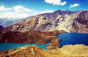
The earthquake triggered numerous landslides along the slopes of the Bartang, Tanimas and Murghab valleys.[2] The largest of these blocked the Murghab river, forming the Usoi Dam and creating the Sarez and Shadau lakes. The Usoi landslide had an estimated volume of about 2 km3. The dam is the highest in the world at about 600 m,[5] impounding a lake containing 17.5 km3 of water.[6] The slide originated from a 4,500 m high mountain, falling 1,800 m to its present location.
Damage
The area of greatest damage extended along the Bartang River from Basid in the west continuing along the Murghab River to Sarez in the east, also involving the kishlaks of Barchidiv, Nisur, Sagnob, Rukhch and Oroshor.[1] The Usoi landslide completely destroyed the Usoi kishlak. Estimates of casualties from the earthquake and related landslides range from 90[1] to 302.[2]
Aftermath
The landslides and the formation of Sarez Lake caused significant migration of the inhabitants of the upper Bartang valley.[7]
See also
References
- 1 2 3 4 NGDC. "Comments for the Significant Earthquake". Retrieved 9 June 2011.
- 1 2 3 4 5 Oldham, R.D. (1923). "The Pamir Earthquake of 18th February, 1911". Quarterly Journal of the Geological Society. 79: 237–245. doi:10.1144/GSL.JGS.1923.079.01-04.15. Retrieved 9 June 2011.
- ↑ Sarkar, I; Sanyal S (2004). "Static stress transfers in the Pamir Hindu Kush seismic zone" (PDF). Journal of Asian Earth Sciences. 23 (4): 449–59. Bibcode:2004JAESc..23..449S. doi:10.1016/S1367-9120(03)00178-0. Retrieved 11 June 2011.
- ↑ Varga, P; Krumm, F.; Riguzzi, F.; Doglioni, C.; Süle, B.; Wang, K.; Panza, G. F. (2010). "Earthquake energy distribution along the earth surface and radius" (PDF). IT: ICTP. Retrieved 11 June 2011.
- 1 2 Havenith, H-B.; Bourdeau C. (2010). "Earthquake-induced landslide hazards in mountain regions: a review of case histories from Central Asia". Geologica Belgica. 13 (3): 137–152. Retrieved 11 June 2011.
- ↑ Asian Disaster Reduction Center. "Country report 2003: Tajikistan". Retrieved 11 June 2011.
- ↑ Dodykhudoeva, L. (2007). "Revitalization of minority languages: comparative dictionary of key cultural terms in the languages and dialects of the Shugni-Rushani group". In Austin P.K., Bond O. & Nathan D. Proceedings of Conference on Language Documentation and Linguistic Theory (PDF). p. 69. ISBN 978-0-7286-0382-0. Retrieved 11 June 2011.