1938 Atlantic hurricane season
| |
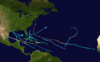
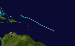
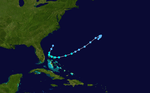
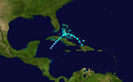
| Season summary map |
| First system formed |
January 3, 1938 (record earliest) |
| Last system dissipated |
November 10, 1938 |
| Strongest storm1 |
"Great New England" – 940 mbar (hPa) (27.76 inHg), 160 mph (260 km/h) |
| Total depressions |
15 |
| Total storms |
9 |
| Hurricanes |
4 |
| Major hurricanes (Cat. 3+) |
2 |
| Total fatalities |
701 |
| Total damage |
$290.3 million (1938 USD) |
| 1Strongest storm is determined by lowest pressure |
Atlantic hurricane seasons
1936, 1937, 1938, 1939, 1940 |
The 1938 Atlantic hurricane season was a period of annual tropical cyclone formation in the Atlantic, lasting from June 16 through October 31. These dates conventionally delimit the period of each year when most tropical cyclones form in the Atlantic basin.
Storms
Hurricane One
| Category 1 hurricane (SSHWS) |
|
|
| Duration |
January 3 – January 6 |
| Peak intensity |
80 mph (130 km/h) (1-min) ≤ 992 mbar (hPa) |
On January 1, a weak extratropical cyclone formed about 2,000 miles (3,200 km) southwest of the island of São Miguel in the Azores. Moving eastward initially, it later began a turn to the south on January 3. On that day, the cyclone transitioned into a warm-core system, a tropical storm with winds of 60 miles per hour (97 km/h). Henceforth, it gradually curved to the southwest and on January 4 became a hurricane, equal to Category 1 on the modern Saffir-Simpson Hurricane Scale. It peaked at 80 mph (130 km/h) that same day but weakened into a tropical storm on January 5. Turning to the south-southwest, it dissipated on January 6 while centered well to the east of the Lesser Antilles. The cyclone became the first documented Atlantic tropical cyclone to attain hurricane intensity in the month of January and is one of just six Atlantic storms known to have occurred in that month, the others being a tropical storm in 1951, Hurricane Alice in 1955, a subtropical storm in 1978, Tropical Storm Zeta in 2006 and Hurricane Alex in 2016.[1]
Tropical Storm Two
| Tropical storm (SSHWS) |
|
|
| Duration |
August 8 – August 9 |
| Peak intensity |
70 mph (110 km/h) (1-min) 1002 mbar (hPa) |
The second storm of the season formed in the area of Antigua on August 8 and moved generally westward, passing just north of Tortola with winds of 70 mph (110 km/h). After nearly attaining hurricane strength, the rather small cyclone weakened and passed north of San Juan, Puerto Rico. On August 9, it made landfall in the Dominican Republic with winds of 50 mph (80 km/h) before dissipating over the mountains of Hispaniola. Some of the smaller islands sustained damage but the only other effects were squally weather.[1]
Hurricane Three
| Category 2 hurricane (SSHWS) |
|
|
| Duration |
August 10 – August 15 |
| Peak intensity |
100 mph (155 km/h) (1-min) 995 mbar (hPa) |
The second hurricane of the season formed south-southeast of Barbados on August 9 and moved west-northwest at a high rate of speed, strengthening into a hurricane as it passed just north of Jamaica. Becoming a Category 2 storm while near Grand Cayman, Storm Three bypassed the northern tip of the Yucatán Peninsula but caused little effect, perhaps due to its small size. The hurricane curved more to the northwest as it entered the Gulf of Mexico, weakening shortly before it reached the coast. Storm Two made landfall near Cameron, Louisiana, as a minimal hurricane with winds of 75 mph (121 km/h), causing moderate flooding of lowlands and $250,000 in damage (1938 dollars, $3.4 million in 2006 dollars). The storm dissipated over east Texas.[1]
Hurricane Four
| Category 3 hurricane (SSHWS) |
|
|
| Duration |
August 23 – August 29 |
| Peak intensity |
120 mph (195 km/h) (1-min) ≤ 964 mbar (hPa) |
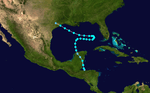
The fourth storm of the season was discovered as a strengthening tropical storm in the central Caribbean Sea on August 23. The storm became a hurricane the next day and maintained a northwest track, steadily strengthening. Storm Three became a major hurricane, with winds equivalent to Category 3 intensity, a day later and maintained that intensity until landfall on August 26 near present-day Tulum, located on the Yucatán Peninsula. Peak winds at landfall were near 120 mph (190 km/h) as Cozumel reported 964 millibars (28.47 inHg) and 91 mph (146 km/h) an hour before the worst conditions arrived. The cyclone weakened to a Category 1 as it passed inland and began to curve more to the west as it crossed the Gulf of Mexico. Hurricane Four made landfall on August 27 north of Tampico with winds of 85 mph (137 km/h), though it may have been stronger than this as it was compact in size at landfall and few observations were available near the eye. This storm caused tremendous flooding on the Yucatán peninsula and killed nine people.[1]
Tropical Storm Five
| Tropical storm (SSHWS) |
|
|
| Duration |
September 9 – September 14 |
| Peak intensity |
40 mph (65 km/h) (1-min) 1009 mbar (hPa) |
A tropical wave that originated near Cape Verde eventually became a tropical depression on September 9 while centered about 2,000 mi (3,200 km) east of Barbados. Moving northwest over the next three days, it eventually turned to the west-northwest on September 13 as it strengthened into a weak tropical storm. It soon weakened and dissipated the next day while located 300 mi (480 km) north of Puerto Rico.[1]
Hurricane Six
| Category 5 hurricane (SSHWS) |
|
|
| Duration |
September 9 – September 22 |
| Peak intensity |
160 mph (260 km/h) (1-min) ≤ 940 mbar (hPa) |
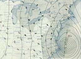
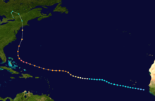
By far the most significant hurricane of the 1938 season, Hurricane Six, better known as the Great New England hurricane, was a Cape Verde-type hurricane that caused great destruction across the northeastern United States.
The storm formed from an African wave in early September and tracked westward across the Atlantic. At first, the storm was slow to strengthen, remaining a tropical storm for five days during its travel westward. It finally became a hurricane before crossing 45°W while located several hundred miles east of the Leeward Islands. The storm continued to steadily strengthen and began to take a more northwesterly course. The Long Island Express, as it was nicknamed, peaked as a Category 5 hurricane on the Saffir Simpson Hurricane Scale while just east of the Bahamas with winds reaching a sustained 160 mph (260 km/h). Following its peak, on September 20, the storm turned due north and accelerated, reaching an unusually fast forward speed of 70 mph (110 km/h), making it the fastest-moving Atlantic tropical cyclone on record. It made landfall on September 21 near Bellport, New York, with sustained winds of 120 mph (190 km/h) and an atmospheric pressure of 941 mbar (27.79 inHg) in the eye. It then made a second landfall near Bridgeport, Connecticut, with winds of 115 mph (185 km/h) and a slightly higher pressure of 946 mbar (27.94 inHg).[1] Nearly 700 people died in the storm (682) and damages came to over $300 million, $4.5 billion in 2007 dollars.
Tropical Storm Seven
| Tropical storm (SSHWS) |
|
|
| Duration |
October 10 – October 17 |
| Peak intensity |
60 mph (95 km/h) (1-min) 996 mbar (hPa) |
This storm formed from a disturbance off the north coast of Honduras on October 10 and almost immediately crossed into Belize, heading north up the Yucatán Peninsula and into the Gulf of Mexico, where it began to move erratically. In the central Gulf on October 12, it made a rather sudden turn to the east, toward Florida. However, a couple of days later, Storm Seven slowed down and began to turn back toward the west northwest, at which time it began to accelerate, weakening along the way. On October 17, the system finally made landfall along the north Texas coast near Galveston with winds of only 45 mph (72 km/h). No significant impact was reported.[1]
Tropical Storm Eight
| Tropical storm (SSHWS) |
|
|
| Duration |
October 16 – October 21 |
| Peak intensity |
40 mph (65 km/h) (1-min) 1004 mbar (hPa) |
Tropical Storm Eight, possibly a subtropical storm, was a weak storm that took a somewhat unusual southwesterly course. It formed near Bermuda on October 16, brushing by the island on its southwesterly path, on which it remained for the two days. On October 19, it hooked back northeast across the northern Bahamas and dissipated two days later.[1]
Tropical Storm Nine
| Tropical storm (SSHWS) |
|
|
| Duration |
November 6 – November 10 |
| Peak intensity |
70 mph (110 km/h) (1-min) ≤ 1000 mbar (hPa) |
The final storm of the 1938 season formed off the north coast of Haiti on November 6 and quickly moved northwest into the Bahamas, during which time it reached its peak intensity of 70 mph (110 km/h); near-hurricane force, before curving back to the southwest while crossing Andros Island. Now in a weakening trend, the storm crossed central Cuba on November 9 and dissipated in the Western Caribbean the following day. No one is reported to have died in the storm and damage to the Caribbean islands is unknown, but the Florida coast suffered $100,000 worth of beach erosion.[1]
See also
References
- 1 2 3 4 5 6 7 8 9 National Hurricane Center; Hurricane Research Division; Atlantic Oceanographic and Meteorological Laboratory (December 2012). "Atlantic hurricane best track (HURDAT) Meta Data, 1938". United States National Oceanic and Atmospheric Administration's Office of Oceanic & Atmospheric Research. Retrieved 2012-12-20.
External links
|
|---|
|
| |
|
-
 Book Book
-
 Category Category
-
 Portal Portal
-
 WikiProject WikiProject
-
 Commons Commons
|