Green Line (Israel)

The Green Line or (pre-)1967 border or 1949 Armistice border[1] is the demarcation line set out in the 1949 Armistice Agreements between the armies of Israel and those of its neighbors (Egypt, Jordan, Lebanon and Syria) after the 1948 Arab–Israeli War. It served as the de facto borders of the State of Israel from 1949 until the Six-Day War in 1967.
The name comes from the green ink used to draw the line on the map while the armistice talks were going on.[2] After the Six-Day War, the territories captured by Israel beyond the Green Line came to be designated as East Jerusalem, the West Bank, Gaza Strip, Golan Heights, and Sinai Peninsula (the Sinai Peninsula has since been returned to Egypt as part of the 1979 peace treaty). These territories are often referred to as Israeli-occupied territories.
The Green Line was intended as a demarcation line rather than a permanent border. The 1949 Armistice Agreements were clear (at Arab insistence[3]) that they were not creating permanent borders. The Egyptian–Israeli agreement, for example, stated that "the Armistice Demarcation Line is not to be construed in any sense as a political or territorial boundary, and is delineated without prejudice to rights, claims and positions of either Party to the Armistice as regards ultimate settlement of the Palestine question."[4] Similar provisions are contained in the Armistice Agreements with Jordan and Syria. The Agreement with Lebanon contained no such provisions, and was treated as the international border between Israel and Lebanon, stipulating only that forces would be withdrawn to the Israel–Lebanon border.
The Green Line is often referred to as the "pre-1967 borders" or the "1967 borders" by many international bodies and national leaders, including the United States president (currently Barack Obama),[5] Palestinian president Mahmoud Abbas,[6] by the United Nations (UN) in informal texts,[7] and in the text of UN General Assembly Resolutions.[8]
History

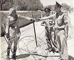
The Green Line refers to the demarcation lines, rather than permanent borders, between Israeli forces and those of its neighbours.[3] All movement across the demarcation lines was banned and monitored by the United Nations Truce Supervision Organization. Most commonly, the term was applied to the boundary between Jordan-controlled Jerusalem and the West Bank and Israel. The drawing of the Green Line superseded entirely the partition lines proposed and voted on by the United Nations in the Partition Plan of 1947 and which Israel had accepted in the Israeli Declaration of Independence. The Palestinian and Arab leaders had repeatedly rejected any permanent partition of Mandatory Palestine.
In 1967, after Israel seized all the territories of the former Mandatory Palestine, as well as other territories, the demarcation lines became militarily irrelevant, and the status of the Green Line became uncertain.
Although Israel has always formally argued that the Green Line has no legal significance, the Green Line continued to have political, legal and administrative significance. Israel regarded the territories beyond the Green Line, unlike those within the Green Line, as occupied territories, and they were not incorporated into Israeli political and civilian administrative systems. The territories beyond the Green Line were administered by the Israeli military or later also by the Palestinian Authority.[9][10] Citizenship by residence, for example, was determined with reference to the Green Line, as well as a person's refugee status.
The extension of the municipality boundary of Jerusalem in 1980 was an exception to this position. Although Jerusalem was a part of territory beyond the Green Line that was occupied by Jordan until 1967, Israel declared Jerusalem "complete and united" as the capital of Israel according to the 1980 Basic Jerusalem Law.[11][12] This claim has not been recognised by any country or by the United Nations (UN) Security Council.[11][12] A notional Green Line continues to divide Jerusalem at the boundary of East Jerusalem.
The Golan Heights are another exception, having been informally incorporated by Israel with the 1981 Golan Heights Law. The UN Security Council declared this to be null and without any international legal effect.[13] Israeli settlements in these areas are essentially subject to the laws of Israel rather than those of the Palestinian Authority.
Impact
The sections of the Green Line that delineate the boundaries between Israel, the West Bank and Gaza run through heavily populated regions. The Line corresponds to the military front of the 1948 War, and while the considerations dictating its placement were primarily military, it soon became clear that in many places it divided towns and villages, and separated farmers from their fields. Consequently, the Green Line underwent various slight adjustments, and special arrangements were made for limited movement in certain areas.[14]
Jerusalem was divided in half, into East and West Jerusalem. The village of Barta'a, partially due to errors on the map, was left with one third of its area on the Israeli side and two thirds outside of it. Kibbutz Ramat Rachel was left almost entirely outside the Israeli side of the Green Line.[14]
According to Avi Shlaim, in March 1949 as the Iraqi forces withdrew and handed over their positions to the Jordanian legion, Israel carried out Operation Shin-Tav-Shin which allowed Israel to renegotiate the cease fire line in the Wadi Ara area of the northern West Bank in a secret agreement that was incorporated into the General Armistice Agreement. The green line was redrawn in blue ink on the southern map to give the impression that a movement in the green line had been made.[15]
Jewish population
During the war in 1947-48, Jews residing east of the Line, including the Jewish Quarter of the Old City, were taken prisoner by the Jordanians. All but a few of the Gush Etzion defenders were massacred. The prisoners were returned to Israel after the war.[9] On July 8, 1948, the Jewish inhabitants of Kfar Darom and Naharayim were evacuated by Israel due to military pressure by Egypt and Jordan. Israel also withdrew from villages in the Lebanese Upper Galilee, whereas Syria withdrew from Mishmar HaYarden.
Since Israel's victory in the Six-Day War, Israel has established settlements south and east of the Line. These have been strongly criticised by other nations.
Many Israelis believe that the settlements are important to Israel's security and also support the settlements ideologically. In contrast, many Israelis believe the settlements are an economic burden and a barrier to peace.[16]
From August to September 2005, Israel implemented a unilateral disengagement plan in which the entire Jewish population of the Gaza Strip was evacuated. In 2006, Ehud Olmert proposed a convergence plan that called for Israel to disengage, unilaterally, if necessary, from much of the West Bank (east of the line).
Arab population
The majority of Palestinian Arabs on the Israeli side of the Line fled or were expelled during the 1948 Arab-Israeli War (around 720,000). Those who remained became Israeli citizens and now comprise approximately 20% of Israel's total citizenry. The Umm al-Fahm-Baqa al-Gharbiyye-Tira area, known as the "Triangle," was originally designated to fall under Jordanian jurisdiction, but Israel demanded its inclusion on the Israeli side due to military and strategic considerations. To achieve this, a territorial swap was negotiated with Transjordan, giving the latter Israeli territory in the southern hills of Hebron in exchange for the Triangle villages in Wadi Ara.[9]
In the Six-Day War, Israel occupied territories beyond the Green Line that were inhabited by over a million Palestinian Arabs, including refugees from the 1947–1949 war.[17] The Green Line remained the administrative border between these territories (with the exception of Jerusalem) and the areas on the Israeli side of the Green Line.
In 1967, Israel annexed East Jerusalem and gave its Arab inhabitants permanent residency status. They were also entitled to apply for Israeli citizenship. Domestically, Israel attempted to emphasize the status of East Jerusalem as part of Israel by its 1980 Jerusalem Law. United Nations Security Council Resolution 478 deemed the law null and void, and this status has not been recognised by any other nation.[18]
In 1981, the Knesset enacted the Golan Heights Law, ostensibly as a reaction to Syrian provocations. This extended the Israeli rule of law to the Golan Heights.[19] (It was also thought to have been motivated by the recent US AWACS sale to Saudi Arabia.[20]) This act was widely considered an informal annexation. It was criticized by the United States as a violation of the Camp David Accords[19] and condemned by the UN Security Council in Resolution 497.[21]
Israeli–Palestinian conflict
In a December 1969 speech, US Secretary of State William P. Rogers said that "any changes in the pre-existing [1949 armistice] lines should not reflect the weight of conquest and should be confined to insubstantial alterations required for mutual security. We do not support expansionism."[22] Harvard law professor Stephen M. Schwebel responded that "...modifications of the 1949 armistice lines among those States within former Palestinian territory are lawful (if not necessarily desirable), whether those modifications are...'insubstantial alterations required for mutual security' or more substantial alterations—such as recognition of Israeli sovereignty over the whole of Jerusalem." In a footnote, he wrote: "It should be added that the armistice agreements of 1949 expressly preserved the territorial claims of all parties and did not purport to establish definitive boundaries between them."[22]
The question of whether, or to what extent, Israel should withdraw its population and forces to its side of the Green Line remains a crucial issue in some discussions surrounding the Israeli–Palestinian conflict. There is a near-unanimous international consensus that Israel should withdraw to its side of the line. This has been expressed in the yearly UN General Assembly vote on the Peaceful Settlement of the Question of Palestine.[23] Although disputed by Israel, UN resolution 242[24] has declared the interpretation of international law regarding Palestinian Territory.
The Palestinians were not party to the drawing of the Green Line and they rejected UN resolution 242, saying that it did not call for an independent Palestinian state, and referred to them as refugees. Since 1976, most elements in the PLO have accepted the pre-June 1967 line as a basis for the establishment of a Palestinian state.[25]
In the early 1980s, American intellectual Noam Chomsky argued that Israeli claims that the Palestinian leadership rejected the international consensus calling for a Palestinian state, with borders along the Green Line, were not consistent with the documented record.[26] In 2008 Al Jazeera and Haaretz both reported that elements in the Palestinian leadership, even inside Hamas, have called for a two-state settlement based on the pre-June 1967 borders (the Green Line).[27][28] Although Hamas' official policy is committed to Israel's destruction, Ismail Haniya, the prime minister of the Palestinian unity government until June 2007, suggested that a long-term truce with Israel could be achieved if Israel withdrew from territory occupied in 1967.[29]
The majority of the Israeli public opposes reverting to pre-1967 borders. A 2011 study found that, because of security concerns, 77% of Israelis oppose returning to pre-1967 lines, even if it would lead to peace between Israel and neighboring Arab states.[30]
The Israeli West Bank barrier constructed in the early 21st century is, in parts, kilometres away from the Green Line; but most lies within Palestinian territory.[31]
Physical and social perceptions of the Green Line
According to Hebrew University geographer Ilan Salomon, the Green Line can be discerned from space via satellite; it is marked by pine forests planted by the Jewish National Fund to demarcate Israeli territory. Salomon and Larissa Fleishman conducted a 2006 study regarding Israeli students' knowledge of the location of the Green Line, and they found that not much more than ⅓ could identify its placement. They learned that "students who identify with left-leaning parties are more familiar with the location of the West Bank and the Gaza Strip, can sketch them more accurately and are also more aware of the nature of borders."[32]
See also
- At the Green Line
- Blue Line (Lebanon)
- Israeli–Palestinian peace process
- Mixed Armistice Commissions
- Purple Line (ceasefire line)
References
- ↑ Custodians and Redeemers: Israeli Leaders' Perceptions of Peace, 1967-79. Amnon Sella, 1986
- ↑ Green Line: the name given to the 1949 Armistice lines that constituted the de facto borders of pre-1967 Israel — "Glossary: Israel", Library of Congress Country Studies
- 1 2 Bernard Lewis (1993). Islam in history: ideas, people, and events in the Middle East. Open Court Publishing. p. 164. ISBN 0-8126-9518-6.
- ↑ Egypt Israel Armistice Agreement UN Doc S/1264/Corr.1 23 February 1949
- ↑ "Obama calls for Israel's return to pre-1967 borders" By Tom Cohen, CNN, May 19, 2011
- ↑ "Palestinian leader Abbas affirms hope for state in pre-1967 lines" BBC News, 2 November 2012,
- ↑ "The Committee on the Exercise of the Inalienable Rights of the Palestinian People (CEIRPP) is mandated by the UN General Assembly to (...) support the peace process for the achievement of the two-State solution on the basis of pre-1967 borders..."
- ↑ for example, "A/RES/67/120 Israeli settlements in the Occupied Palestinian Territory, including East Jerusalem, and the occupied Syrian Golan" Resolution adopted by the General Assembly on 18 December 2012
- 1 2 3 Yisrael Ya'akov Yuval, "Where is the Green Line", Two Thousand, Vol. 29, no. 971, 2005 (Hebrew)
- ↑ Akiva Eldar, "What is the Green Line", Haaretz, July 21, 2006 (Hebrew)
- 1 2 Anthony Aust (2010). Handbook of International Law By Anthony Aust. https://books.google.com/books?id=74Zmct-7hGIC&pg=PA27: Cambridge University Press. p. 27. ISBN 978-0-521-13349-4.
- 1 2 Ian Lustick (January 1997). "Has Israel Annexed East Jerusalem?". Middle East Policy. V (1). Archived from the original on 2007-06-10. Retrieved 2007-07-08.
- ↑ Mohammad Taghi Karoubi (2004). Just or unjust war?. https://books.google.com/books?id=D9mI3Nqug5EC&pg=PA120: Ashgate Publishing. ISBN 978-0-7546-2375-5.
- 1 2 Yossi Alpher, et al., "The green line", Palestinian-Israeli crossfire, Edition 8, February 24, 2003
- ↑ The Politics of Partition; King Abdullah, The Zionists, and Palestine 1921–1951 Avi Shlaim Oxford University Press Revised Edition 2004 ISBN 0-19-829459-X pp. 299, 312
- ↑ "סקר: יותר ישראלים רואים במתנחלים "מכשול לשלום"". Walla!. 11 June 2016. Retrieved 10 October 2016.
- ↑ The new territories more than doubled the size of pre-1967 Israel, placing under Israel's control more than 1 million Palestinian Arabs ... In November 1967 ... UN Security Council Resolution 242, called for "withdrawal of Israeli armed forces from territories occupied in the recent conflict" in exchange for Arab acceptance of Israel — "Israel: 1967 and Afterward", Library of Congress Country Studies
- ↑ "S/RES/476 (1980) of 30 June 1980". domino.un.org. Retrieved 2015-10-01.
- 1 2 "THE GOLAN HEIGHTS ANNEXED BY ISRAEL IN AN ABRUPT MOVE". www.nytimes.com. Retrieved 2015-10-01.
- ↑ "Golan Heights Law - Center for Israel Education". Retrieved 2015-10-01.
- ↑ "S/RES/497 (1981) of 17 December 1981". unispal.un.org. Retrieved 2015-10-01.
- 1 2 S. M. Schwebel (1970). "What weight to conquest?". American Journal of International Law. 64: 344–347.; reprinted in S. M. Schwebel (1994). Justice in international law: selected writings of Stephen M. Schwebel. https://books.google.com/books?id=ZWJTqMjA5OkC&pg=PA524: Cambridge University Press. p. 524. ISBN 978-0-521-46-284-6.
- ↑ Fouad Moughrabi. "The International Consensus on the Palestine Question", Journal of Palestine Studies, 1987
- ↑ Eric Black. "Resolution 242 and the Aftermath of 1967", PBS/Star Tribune, 1992
- ↑ "Draft Resolution 'The Middle East problem', Security Council document S/11940, 23 January 1976" Israel Ministry of Foreign Affairs, Retrieved 22 September 2010
- ↑ Noam Chomsky, The Fateful Triangle: The United States, Israel and the Palestinians, South End Press 1983/1999 pp. 95-173. ISBN 0-89608-601-1
- ↑ "Hamas ready to accept 1967 borders", Al Jazeera, 22 April 2008
- ↑ Amira Hass. "Haniyeh: Hamas willing to accept Palestinian state with 1967 borders", Haaretz, 9 November 2008
- ↑ "Middle East", BBC; retrieved on 28/07/2011
- ↑ Hoffman, Gil. "Poll: 77% of Israelis oppose going back to pre-'67 lines". jpost.com. Jerusalem Post. Retrieved 16 June 2015.
- ↑ Barahona, Ana (2013). Bearing Witness - Eight Weeks in Palestine. London: Metete. p. 52. ISBN 978-1-908099-02-0."The Green Line"
- ↑ Akiva Eldar. "Putting back the Green Line - once we find it" Haaretz, December 8, 2006
Further reading
- Gad Barzilai and Ilan Peleg, "Israel and Future Borders: Assessment of a Dynamic Process", Journal of Peace Research, Vol. 31, No. 1 (February 1994), pp. 59–73
- Bornstein, Avram S. Crossing the Green Line Between the West Bank and Israel, University of Pennsylvania Press, 2001; Unfavourable review by Steven Plaut, Middle East Forum, Vol. 10, No. 3, (Spring 2003); Favourable review by Matthew S. Gordon, Journal of Colonialism and Colonial History, Vol. 4, No. 2 (Fall 2003)
- S. Brian Willson, "History of Palestine and Green Line Israel", Most Dangerous of Rogue Nation, 1992, Revised May 2002
- David Newman, "Boundaries in Flux: The 'Green Line' Boundary between Israel and the West Bank - Past, Present and Future", Boundary & Territory Briefings, Vol. 1 no. 7, 1995.
- David Newman, "The functional presence of an 'erased' boundary: The re-emergence of the 'green line'"; from Schofield C.H. and Schofield R.N. (eds.). World Boundaries: the Middle East and North Africa, Routledge, London, 1995 (ISBN 0415088399)
- Nadim Rouhana, "The Intifada and the Palestinians of Israel: Resurrecting the Green Line", Journal of Palestine Studies, Vol. 19, No. 3 (Spring 1990), pp. 58–75
- Amb. Alan Baker, The Fallacy of the "1967 Borders" - No Such Borders Ever Existed
- Amb. Dore Gold, 'Land Swaps' and the 1967 Lines
- Ana Barahona Bearing Witness - Eight weeks in Palestine Metete Publications
- Ben-Dror, Elad (2015). Ralph Bunche and the Arab-Israeli Conflict: Mediation and the UN 1947–1949,. Routledge. ISBN 978-1138789883.