1992 Roermond earthquake
 | |
| Date | 13 April 1992 (GMT+1) |
|---|---|
| Magnitude | 5.8 Ml, 5.3 Mw[1] |
| Depth | 18 km[1] |
| Epicenter | 51°10′N 5°57′E / 51.16°N 5.95°ECoordinates: 51°10′N 5°57′E / 51.16°N 5.95°E[1] |
| Type | Dip-slip |
| Areas affected | Netherlands, Germany and Belgium |
| Max. intensity | VII (Very strong) |
| Casualties | None |
The 1992 Roermond earthquake occurred on 13 April, around 3:20 AM (1:20 UTC) with a moment magnitude of 5.3 and a maximum Mercalli intensity of VII (Very strong). Striking on the Peel Boundary Fault, a normal fault near Roermond, it was the strongest recorded earthquake in the Netherlands and in Northwestern Europe, and caused substantial damage to older buildings in the Netherlands and adjacent countries of Belgium and Germany. A series of aftershocks followed.
Tectonic setting
The city of Roermond lies above the Roer Graben, which forms the southeastern part of the Lower Rhine Graben (or Lower Rhine Embayment). These structures form part of the European Cenozoic Rift System, which formed within the foreland of the Alpine orogeny. The Roer graben formed during the Paleogene and is currently active as shown by the thickening of Quaternary sedimentary rocks into the basin. The graben is bounded by NW-SE trending normal fault systems, with the largest fault being the southwest-dipping Peel Boundary Fault, which displaces the base of the Quaternary sequence by about 175 m.[2] All the major faults show evidence of neotectonics.[3]
Location

The earthquake's focal mechanism showed almost pure normal faulting on a plane dipping southwest at 68°, identified as the Peel Boundary Fault.[4] The epicentre of the earthquake lay kilometers away from the south of Roermond.
Intensity
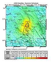
The earthquake was recorded as 5.8 on the Richter magnitude scale (5.3 on the moment magnitude scale) and a maximum intensity of VII (Very strong) on the Mercalli intensity scale.[5]
An intensity of VII means people have difficulty standing, drivers feel their cars shaking, some furniture breaks and loose bricks fall from buildings. Damage is slight to moderate in well-built buildings; considerable in poorly built buildings.[6] The earthquake was not evenly spread as some areas were hit harder than others. This earthquake could be felt as far away as the Czech Republic, Switzerland, France and England.[5]
Damage
In the regions between Roermond, Maaseik (Belgium), and Heinsberg (Germany), buildings, especially old buildings, and cars were destroyed.[5] Two churches in Roermond, the Munsterkerk and Minderbroederskerk, were heavily damaged.[7][8] The economic cost of the earthquake was estimated to be around 275 million guilders (around 125 million euros), of which 170 million guilders of damage in the Netherlands.[5]
Aftershocks
The earthquake was followed by more than 200 aftershocks.[9]
See also
References
- 1 2 3 "An earthquake catalogue for central, northern and northwestern Europe based on Mw magnitudes / Annex. STR 03/02" (PDF). GeoForschungsZentrum Potsdam. p. 142. Retrieved 20 February 2015.
- ↑ Braunmiller J., Dahm T. & Bonjer K-P. (1994). "Source mechanism of the 1992 Roermond earthquake from surface- wave inversion of regional data" (PDF). Geophysical Journal International. 116: 663–672. doi:10.1111/j.1365-246x.1994.tb03288.x.
- ↑ Houtgast R.F. & van Balen R.T. (2000). "Neotectonics of the Roer Valley Rift System, the Netherlands" (PDF). Global and Planetary Change. 27 (1-4): 131–146. doi:10.1016/S0921-8181(01)00063-7.
- ↑ Oncescu M-C., Camelbeek T. & Martin H. (1994). "Source parameters for the Roermond aftershocks of 1992 April 13- May 2 and site spectra for P and S waves at the Belgian seismic network" (PDF). Geophysical Journal International. 116: 673–682. doi:10.1111/j.1365-246x.1994.tb03289.x.
- 1 2 3 4 "Aardbeving bij Roermond 13 april 1992". Royal Netherlands Meteorological Institute. 31 May 2010. Retrieved 18 February 2014.
- ↑ "The Modified Mercalli Scale of Earthquake Intensity". The Nevada Seismological Laboratory. Retrieved 18 February 2014.
- ↑ (Dutch) Munsterkerk, Municipality of Roermond. Retrieved on 25 February 2015.
- ↑ (Dutch) Minderbroederskerk, Municipality of Roermond. Retrieved on 25 February 2015.
- ↑ Camelbeeck, T.; Van Eck, T.; Pelzing, R.; Ahorner, L.; Loohuisz, J.; Haak, H.W.; Hoang-Trong, P.; Hollnack, D. (1994). "The 1992 Roermond earthquake, the Netherlands, and its aftershocks" (PDF). Geologie en Mijnbouw. Kluwer Academic Publishers. 73: 181–197. Retrieved 25 February 2015.
External links
-
 Media related to 1992 Roermond earthquake at Wikimedia Commons