Aşağı Qışlaq
| Aşağı Qışlaq | |
|---|---|
| Municipality | |
 Aşağı Qışlaq | |
| Coordinates: 39°28′10″N 45°42′07″E / 39.46944°N 45.70194°ECoordinates: 39°28′10″N 45°42′07″E / 39.46944°N 45.70194°E | |
| Country |
|
| Autonomous republic | Nakhchivan |
| Rayon | Shakhbuz |
| Population (2005) | |
| • Total | 917 |
| Time zone | AZT (UTC+4) |
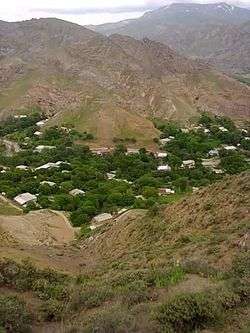
Aşağı Qışlaq (also, Ashagy Kyshlak and Alimammed-Kyshlagi) is a village and municipality in the Shahbuz District of Nakhchivan, Azerbaijan. It is located 1 km away from the Yevlakh-Lachin-Nakhchivan highway, 12 km in the north-east from the district center. Its population is busy with gardening and animal husbandry. There are secondary school, library, communication branch, club and a medical center in the village. It has a population of 917.[1]
Etymology
Aşağı Qışlaq (Ashaghy Kyshlak) - is the foothill area. According to researchers, the second component of the name of Ashaghy Kyshlak, can not be taken to mean as "wintering". Because the area which the villages of the Yukhary (Upper) Kyshlak and Ashaghy (Lower) Kyshlak are located is not suitable for the wintering. The name is associated with the name of one of the arms of the Gyzyl Kyshlak tribe (orta kyshlak, gyullu kyshlak, yazly kyshlak, yazy kyshlak or dyuz kyshlak) of the Turkic Kengerli. The name of Ashaghy Kyshlak as ethno toponym means "as the lower part of the territory, inhabited by the tribe of the kyshlak".[2]
References
- ↑ ANAS, Azerbaijan National Academy of Sciences (2005). Nakhchivan Encyclopedia. volume I. Baku: ANAS. p. 37. ISBN 5-8066-1468-9.
- ↑ Encyclopedic dictionary of Azerbaijan toponyms. In two volumes. Volume I. p. 304. Baku: "East-West". 2007. ISBN 978-9952-34-155-3.
Capital: Şahbuz | ||
.svg.png) | ||