R3 Road (Zimbabwe)
Coordinates: 17°45′39″S 31°58′23″E / 17.76071°S 31.97319°E
R3 Highway is a primary road in Zimbabwe from the capital city Harare to Chirundu.[1][2][3]
ROAD NAMES SOURCE: |Chapter 9: Road Transport Services and Infrastructure External Link.
Background
The highway is also known as the Harare-Chirundu Highway. Its historical and popular name is the A1 Highway[4][5][6] and is 354 kilimetres (220 miles) long.[7] In Harare it can be picked up at the intersection of Samora Machel Avenue (A5) and Leopold Takawira Street. Follow Leopold Takawira north and turn right into Hebert Chitepo Avenue, then left into Sam Nujoma Street up to Lomagundi Road (A1) at cordinates 17°47′01″S 31°02′18″E / 17.78351°S 31.038427°E, and from Chirundu it can be picked from the Chirundu Bridge or the Otto Beit Bridge. ( 16°02′31″S 28°51′41″E / 16.04187°S 28.86148°E )
Pan African Highway Link
Together with the R1 Highway which runs from Harare to Beitbridge, the R3 Highway is part of the North-South Corridor which is the Cairo-Cape Town Highway. (Chirundu to Beitbridge 897 kilometres. "557 miles")[8][9]
The Trans-African Highway 4, alias the Cairo-Cape Town Highway, is the road network, being developed with the collaboration of the African Union, the United Nations Economic Commission for Africa and the African Development Bank. Its length is about 10,228 kilometers connecting Cape Town and Cairo, along with Botswana, Zimbabwe, Zambia, Tanzania, Kenya, Ethiopia, and the Sudan. There are two possible routes in Zimbabwe connecting Zambia and South Africa. The first is from Lusaka to Beitbridge via Victoria Falls and the other is from Lusaka to Beitbridge via Chirundu, Zimbabwe. The Chirundu Route is shorter but not the fastest. For Trans-African Highway transporters, both Zimbabwean .routes are slower and costly.[10][11]
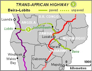
Together with the R5 Highways it forms part of the Beira-Lobito Highway which is the Trans-African Highway Network route number 9.
Rehabilitation
The A1 Highway is currently under rehabilitation together with other regional road corridors in Zimbabwe. Most highways in Zimbabwe are more than 30 years old, outliving their 20-year life span, and they need rehabilitation. The current rehabilitation of this highway is in conformation of the Sadc Regional Infrastructure Master Plan for the North-South Corridor (Africa). North-South Corridor (Africa) is a passage for Southern Africa Development Community (Sadc) exports to the North, and imports to the South. It is important in the handling of regional traffic within Sadc and Comesa.[12]
Waypoints
Waypoints from South to North; Harare to Chirundu.
Banket
The first significant waypoint from Harare is Banket. This waypoint is usually overlapped by motorists because it is only 24.7 km (15.3 mi) before Chinhoyi. -17.38333, 30.4
Chinhoyi
As you enter Chinhoyi, the first billboard you encounter just after the Manyame Bridge notifies you of a rest place just a kilometre away. Ten years from opening its doors, the Chinhoyi University of Technology Hotel has become a favourite stop-over for travellers along the Harare-Chirundu Highway.[13] When you live Chinhoyi towards Karoi about 10 kilometres (6.2 miles) north, (that’s about 136 kilometres (85 mi) from Harare and about before 251 kilometres (156 mi) from Chirundu Border Post is the Chinhoyi Caves Recreational Park, besides the road. The caves are a network of tunnels and caverns which are among the top best and most fascinating places to visit and see in Zimbabwe. The water temperature of the Chinhoyi caves is always at 22 degrees Celsius (72 Fahrenheit) throughout. This might be an option stop-over if you didn,t want to stop in town. Opening hours are 0700 hrs to 1700 hrs (GMT).[14]
Karoi
Karoi is about 85 kilometres (53 miles), by road, north-west of Chinhoyi, that is about 200 kilometres (120 miles) from Harare and around 154 kilometres (96 miles) before Chirundu.
About 8 kilometres (5.0 mi) north of Karoi towards Makuti the Karoi-Gokwe-Binga Roads turns right that will eventually reach Matusadona National Park. Sanyati Bridge is 115 kilometres (71 mi) along this road, west.
Makuti
Makuti is the last significant waypoint before Chirundu. Here the M15 Highways branches sharp right to Kariba through to Zambia’s Siavonga Border Post via the Kariba Dam wall.[15]
Marongora
Marongora Wild life Campsite is about 168 km / 105 miles from Chinhoyi towards Chirundu, that is just more than 166 mi (or 267 km) North-West of Harare.[16][17] Tickets to Manna Pools are gotten here. 16°13′24″S 29°09′41″E / 16.223297°S 29.161436°E
Marongora Map External link. Marongora Office Photo External link.
Bridges
There are several high-level bridges along the highway. However, in during the floods of January 2015 some bridges between Chinhoyi and Karoi flooded, a very rare scenario. Chikuti River Bridge was blocked by flowing water near Lion’s Den before Mhangura Road turn-off.[18] and Denga River Bridge was also blocked.[19][20]
See also
References
- ↑ Google Maps Map Center -17.826817,31.03774 maps.googleapis.com|Maps|Retrieved 18 March 2016
- ↑ Google Maps Map Center -17.826817,31.03774 maps.googleapis.com|Maps|Retrieved 18 March 2016
- ↑ Google Maps Map Center -16.819042,29.683690 maps.googleapis.com|Maps|Retrieved 18 March 2016
- ↑ Google MapsMap Center -17.826817,31.03774 maps.googleapis.com|Maps|Retrieved 18 March 2016
- ↑ Google MapsMap Center -17.826817,31.03774 maps.googleapis.com|Maps|Retrieved 18 March 2016
- ↑ Google Mapshttp://maps.googleapis.com/maps/api/staticmap?center=-16.819042,29.683690&zoom=8&markers=-16.819042,29.683690,red&maptype=terrain&size=550x450|Static Map Center -16.819042,29.683690]maps.googleapis.com|Maps|Retrieved 18 March 2016
- ↑ Info-ZimGuide Border Post Crossing Zimbabwe Zambia|Distances: Harare to Chirundu driving distance is 354 km; Distance between Chirundu and Lusaka is 142 km; Distance between Chirundu and Chinhoyi is 239 km; Distance from Beitbridge to Chirundu is 897 km; Distance between Chirundu and Tunduma is 1158 km; Distance between Chirundu and Nakonde is 1152 km Kariba Dam is 67 km from Chirundu Zimbabwe Tourism|Zim News|Retrieved 28 March 2016
- ↑ Info-ZimGuide Border Post Crossing Zimbabwe Zambia|Distances: Harare to Chirundu driving distance is 354 km; Distance between Chirundu and Lusaka is 142 km; Distance between Chirundu and Chinhoyi is 239 km; Distance from Beitbridge to Chirundu is 897 km; Distance between Chirundu and Tunduma is 1158 km; Distance between Chirundu and Nakonde is 1152 km Kariba Dam is 67 km from Chirundu Zimbabwe Tourism|Zim News|Retrieved 28 March 2016
- ↑ Simon. Corridor News 7 July 2014 from the African Infrastructure Programme | Transport World Africa|Rehabilitation of the Serenge Nakonde Road will involve widening of the road, and its improvement will contribute to cost reduction for road transportation along the North- South and Dar es Salaam Corridors, as well as reduce accident losses for the transport of passengers and goods. Ultimately, it is expected to improve the competitiveness of business in the eight countries that share the North-South Corridor – Botswana, DRC, Malawi, Mozambique, South Africa, Tanzania, Zambia and Zimbabwe. Project completion is expected by 2017. Transport World Africa|Retrieved 28 March 2016
- ↑ North-South Corridor Africa's Main VeinThe North-South corridor provides two distinct road routes to Lusaka, Zambia, from South Africa. One goes through Zimbabwe; the other runs through Botswana. The Zimbabwe route is shorter by around 150 km, but is often slower, due to inefficiencies at the infamous Beitbridge border crossing, where delays with documentation frequently last two or more days Transport World Africa website|January 2016|Retrieved 28 March 2016
- ↑ 12 September 2014 Town Highway: From Vision to Reality in 2015|Also known as the Trans-African Highway, the road network, being developed with the collaboration of the African Union, the United Nations Economic Commission for Africa and the African Development Bank, will be 10,228 kilometers in length, connecting Egypt and South Africa, along with countries in between, such as Botswana, Zimbabwe, Zambia, Tanzania, Kenya, Ethiopia, and Sudan. Egypt Streets|News|Retrieved 28 March 2016
- ↑ Dumisani Nsingo. 28 September 2014 steps up efforts on Sadc infrastructural development|ZIMBABWE has stepped up efforts to ensure it plays a pivotal role in the Sadc Regional Infrastructure Master Plan (RIMP) with a number of transport infrastructural developments linking the country to its neighbours at various stages of implementation. The cross-border projects are estimated at $500 billion and seek to develop infrastructure in power, transport, water, communication, tourism and metrology in the 15 countries over a 15-year period, which started in 2012 and expected to end in 2027. Sunday News|Business|Retrieved 28 March 2016
- ↑ Business Reporter. 17 April 2013 Hotel rings bells for guests | The Herald|Business|Retrieved 29 March 2016
- ↑ Info Chinhoyi Caves Recreational Park ZimGuide|Retrieved 26 March 2016
- ↑ Geotechnical Investigation Testing|1.1Site location...The international road M15 crosses the border on the dam crest. scribd.com|Documents|Retrieved 29 March 2016
- ↑ Marongora tripmondo.com|Retrieved 29 March 2016
- ↑ Zimbabwe - Facts and information on Marongora| (Chinhoyi) is approximately 168 km / 105 mi away from Marongora (as the crow flies). The distance from Marongora to Zimbabwe's capital Harare (Harare) is approximately 269 km / 167 mi (as the crow flies). Zimbabwe.Places-in-the-world.com|Retrieved 29 March 2016
- ↑ Tinomuda Chakanyuka. 4 January 2015 drown as their car is swept away by flooded river|Chikuti Bridge Along Harare-Chirundu Road, which has also been blocked by flowing water near Lion’s Den before Mhangura Road turn-off Sunday News|Local News|Retrieved 29 March 2016
- ↑ Walter Nyamukondiwa and Nyemudzai Kakore. 5 January 2016 leave 100s homeless |In the aftermath of the rains, roads and bridges, especially Chikuti, have been damaged. Hundreds of motorists and travellers were left stranded after Denga River overflowed the Harare-Chirundu Road with one truck being swept off the road.|The Herald|News|Reatrieved 29 March 2016
- ↑ Walter Nyamukondiwa and Nyemudzai Kakore.5 January 2015 || The Herald zw|Top Stories|Retrieved 29 March 2016