Abraham Cresques
| Abraham Cresques | |
|---|---|
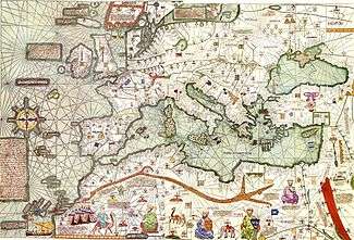 A part of the Catalan Atlas by Cresques Abraham and his son Jehuda Cresques | |
| Born |
1325 Palma, Majorca |
| Died | 1387 |
| Other names | Eliça, son of Rabbi Abraham |
| Occupation | cartographer |
| Known for | Catalan Atlas |
Abraham Cresques (Catalan pronunciation: [əβɾəˈam ˈkɾeskəs], 1325–1387), whose real name was Cresques (son of) Abraham, was a 14th-century Jewish cartographer from Palma, Majorca (then part of the Crown of Aragon). In collaboration with his son, Jehuda Cresques, Cresques is credited with the authorship of the celebrated Catalan Atlas of 1375.
Personal life
A Majorcan Jew, Cresques was a master map-maker and builder of clocks, compasses, and other nautical instruments. He was a leading member of the Majorcan cartographic school.
Abraham Cresques's real name was Eliça (a.k.a. Cresques) son of Rabbi Abraham, son of Rabbi Benaviste, son of Rabbi Eliça. Eliça being the name he would have received when he came of age but known as Cresques of Abraham (Cresques being his personal name, Eliça his religious name, Abraham his patronym), but the order is often flipped in most subsequent literature. His son, Jehuda Cresques, was also a notable cartographer.
The Catalan Atlas
In 1375, Cresques and his son Jehuda received an assignment from Prince John of Aragon (the future John I of Aragon) to make a set of nautical charts which would go beyond the normal geographic range of contemporary portolan charts to cover the East and the West, and everything that, from the Strait [of Gibraltar] leads to the West. For this job, Cresques and Jehuda would be paid 150 Aragonese golden florins, and 60 Mallorcan pounds, respectively, as it is stated in 14th-century documents from the Prince himself and his father Peter IV of Aragon. Prince John intended to present the chart to his cousin Charles (later to be Charles VI, King of France) as a gift. In that year 1375 Cresques and Jehuda drew the six charts that composed the Catalan Atlas at their house in the Jewish quarter of Palma.
Works attributed to Cresques
The Catalan Atlas of c. 1375 is the only map that has been confidently attributed to Cresques Abraham. But researchers have suggested that five other existing maps might also be attributed to Cresques, Jehuda or some other worker in the Cresques atelier.[1] Like the Catalan Atlas itself, these five maps (four portolan charts, one fragment of a mappa mundi), are unsigned and undated, and their date of composition estimated sometime between 1375 and 1400.
- Catalan Atlas, c. 1375, 6 panels, map from the Atlantic Ocean to China, held [2] at the Bibliothèque Nationale de France in Paris, France
- Venice chart, c. 1375-1400, portolan chart (missing northern Europe), held [3] at the Biblioteca Marciana in Venice, Italy
- Florence chart, c. 1375-1400, portolan chart (west Mediterranean only) held (Port.22) at the Biblioteca Nazionale Centrale, Florence, Italy
- Naples chart, c. 1375-1400, normal portolan chart held (ms.XII.D102) at the Biblioteca Nazionale Vittorio Emanuele III in Naples, Italy
- Istanbul map c. 1375-1400, fragment of mappa mundi, held (1828) at the Topkapi Palace in Istanbul, Turkey
- Paris chart, c. 1400, portolan chart held (AA751) at the Bibliotheque Nationale de France in Paris, France
According to Campbell, of the four portolan charts attributed the Cresques atelier, the Naples and Paris charts are more ornate than the other two, with the Paris chart (c. 1400) in particular seeming closest to the features of the Catalan Atlas (c. 1375).[4] However, attribution to the Cresques workshop is only tentative. As Campbell notes, "That this group of charts is closely related is clear. But it is hard to see, from the colour analysis alone, evidence to confirm that these four charts were the product of supervised work in a single atelier."[4]
-
.jpg)
"Venice chart" (It.IV,1912),
Biblioteca Marciana, Venice. -
.jpg)
"Naples chart" (XII.D102),
Biblioteca Nazionale Vittorio Emanuele III, Naples. -
.jpg)
"Paris chart" (AA751),
Bibliotheque Nationale de France, Paris. -
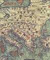
Abraham and Jehuda Cresques Catalan Atlas. Eastern Europe view from the south (detail)
See also
References
- Campbell, T. (2011) Anonymous works and the question of their attribution to individual chartmakers or to their supposed workshops, online
- Pujades i Bataller, Ramon J. (2007) Les cartes portolanes: la representació medieval d'una mar solcada. Barcelona.
External links
- Images of the whole Catalan Atlas Bibliothèque Nationale de France, accessed 2008-03-14
- www.cresquesproject.net—Translation in English of the works of Riera i Sans and Gabriel Llompart on the Jewish Majorcan mapmakers of the Late Middle Ages. They include very complete biographies of Cresques Abraham and his son Jafudà Cresques.