Adriatic–Ionian motorway
| Adriatic–Ionian Motorway | |
|---|---|
 | |
| Major junctions | |
| From: | Trieste, Italy |
| To: | Kalamata, Greece |
| Location | |
| Countries: | Italy, Slovenia, Croatia, Bosnia and Hercegovina, Montenegro, Albania, Greece |
| Major cities: | Trieste, Rijeka, Split, Dubrovnik, Podgorica, Shkodër, Lezhë, Tirana, Durrës, Fier, Gjirokastër, Ioannina, Patras, Kalamata |
| Highway system | |
| Transport in Europe | |
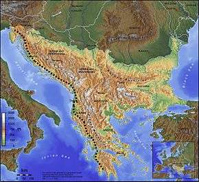
Adriatic–Ionian motorway (Croatian: Jadransko–jonska autocesta; Montenegrin: Jadransko–jonski autoput; Albanian: Autostrada Adriatiko-Joniane) or the Blue Corridor is a future motorway that will stretch along the entire eastern shore of Adriatic and Ionian seas, spanning the western coast of the Balkan peninsula.
Overview
The road is planned to be built to full motorway standards. It will start in Trieste, Italy, pass through Slovenia, enter Croatia near Rijeka, and continue through Croatia as part of A1 motorway. Because the Croatian territory near Dubrovnik is very narrow along the coast, a section of the motorway might pass near Trebinje, Bosnia and Herzegovina before entering Montenegro,[1] but another option might be to connect to Montenegro only through Croatia if currently halted construction of Pelješac Bridge is to be continued. Passing Podgorica, the motorway will enter Albania north of Lake Scutari, and continue south via Shkodër-Tiranë-Durrës-Fier-Gjirokastër. Exiting Albania, the motorway will follow the Greek section of E55 route.
The road is seen as a matter of national importance to Croatia, Montenegro and Albania. Those countries have launched an initiative to list the motorway with Pan-European corridors in order to be able to secure foreign funding.
Italy
With starting of Adriatic–Ionian motorway at Trieste, the already existing feeder road RA 13 to the Slovenian border is used. The RA 13 is connected to the Slovenian A3 highway.
Slovenia
The Slovenian section starts with the already existing A3 from the Italian border at Sežana to the interconnection with the A1. The further route isn't planned yet, but will lead to the Croatian border near Jelšane where it will be connected with the Croatian A7 highway. Until construction of that part, the traffic is passed over a national road.
Croatia
In Croatia, the Adriatic–Ionian motorway is planned to follow routes of the A7 motorway along its entire length, and the A1 motorway from the Žuta Lokva interchange to the south.
So far, Croatia has made the biggest progress on its section by completing significant parts of the A7 motorway and the A1 motorway.
The A7 is completed from the Slovenian border at Rupa, bypassing Rijeka and connecting to the A6. Construction of the part from this junction to a planned interchange with the A1 at Žuta Lokva is currently slowed down and planned as a long-term project. Until completion of this sector, the traffic may either use an indirect route to the A1 via the A6 motorway (to the junction of the A1 and A6 motorways at Bosiljevo 2 interchange) or a more direct route to the A1 via the D8 state road (also known as Adriatic Highway).
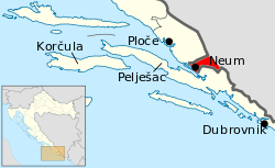
The A1 currently ends near the city of Ploče, and it is planned to end at Dubrovnik, but no concrete plans exist for the motorway route past Metković, and the D8 carries the southeastward traffic after the A1. It intersects the short strip of Bosnia and Herzegovina territory at Neum, but this short strip of Bosnia-Herzegovina territory might be circumvented by Pelješac Bridge and the main course of motorway might stay at the Croatian territory until crossing to Montenegro.
| routing | |||
|---|---|---|---|
| road | stretch | distance | status |
| |
border Slovenia / Rupa - Matulji | 16 km | completed |
| |
Matulji - Orehovica | 12 km | completed (cca 135 km from Orehovica taking the existing motorway A6/A1 via Bosiljevo to Žuta Lokva) |
| |
Orehovica - Sveti Kuzam - Križišće | 14 km | completed |
| |
Križišće - Žuta Lokva | 69 km | planned, now D8 to Senj and D23 to Žuta Lokva (i.e. total 83 km from Orehovica taking the A6/A1 via Bosiljevo) |
| |
Žuta Lokva - Zadar - Split - Ploče | 360 km | completed |
| |
Ploče intersection - Slivno | cca 25 km | planned |
| |
Slivno - Doli | stretch not defined | |
| |
Doli - Dubrovnik (Osojnik) | cca 35 km | planned |
Bosnia and Herzegovina
It has not yet been defined whether a motorway will pass through southern Bosnia and Herzegovina near Trebinje. A route passing through the Trebinje field would require approval of both the Herzegovina-Neretva Canton and Republika Srpska.
Montenegro

In the Spatial Plan of Montenegro, route of the Adriatic – Ionian motorway is currently defined as following:
- Nudo (border with Bosnia and Herzegovina) - Grahovo - Čevo - (Podgorica) Mareza - (Podgorica) Smokovac - Dinoša - Božaj (Border with Albania)
Thus, Government of Montenegro has considered only the option of motorway crossing southern Bosnia and Hercegovina near Trebinje. A parallel expressway along the coast is also planned, that will connect directly to Croatian road network at Debeli Brijeg, however, this is not considered a part of Adriatic – Ionian route, and will not be built to full motorway standard. This route is intended to relieve Adriatic Highway, and will follow the Montenegrin coastline closely, with Verige bridge included in its route.
Approximate length of motorway through Montenegro is 100 km, of which 10 km between Mareza and Smokovac is shared with Belgrade–Bar motorway.
Building of the Belgrade–Bar motorway is currently a priority for Montenegro, and concrete activities on building Adriatic – Ionian motorway are yet to begin.
Albania
Albania has mostly completed its north-south corridor (SH1 and SH4) connecting Montenegro with Greece. Remaining parts of the corridor are still to be completed like the Shkoder Bypass and Fier Bypass. The motorway in Albania may pass along Boshti i Jugut (English: Southern Axis) stretching along south-central Albania.[2] However, it may also pass on the current stretch along the western lowland, and enter inland at Fier towards Tepelene and Gjirokaster. Less than half of the above segments are single carriageways known as superstradë, while segments SH4 Durrës-Vlorë and SH1/A1 Milot-Thumanë have been widened to dual carriageways known as autostradë.
| routing | |||
|---|---|---|---|
| road | stretch | distance | status |
| |
Montenegro border / Hani i Hotit - Shkodër | ca. 31 km | completed as a single carriageway (superstradë) |
| |
Shkodër (Shkoder Bypass)- Milot | ca. 50 km | completed as a single carriageway (superstradë), Shkoder Bypass construction started. |
| |
Milot - Fushë-Kruja | ca. 22 km | completed as a dual carriageway (autostradë) |
| |
Fushë-Kruja - Vora | ca. 13 km | completed as a single carriageway (superstradë) |
| |
Vora - Durrës | ca. 18 km | completed as a dual carriageway (autostradë) |
| |
Durrës - Rrogozhina | ca. 33 km | completed as a dual carriageway (autostradë) |
| |
Rrogozhina - Mbrostar | ca. 42 km | completed as a dual carriageway (autostradë) |
| |
Mbrostar - Levan (Fier Bypass) | ca. 12 km | under construction |
| |
Levan - Tepelena | ca. 69 km | completed as a single carriageway (superstradë) |
| |
Tepelena - Kakavija / Greece border | ca. 58 km | completed as a single carriageway (superstradë) |
Greece
Greece is building its A5 motorway (called Ionia Odos) in order to replace the existing National road GR-5 (from Ioannina to Rio). The already built Rio–Antirrio bridge is part of the A5. The length of the motorway is 200 km and its going to be completed in 2017.
From Rio to Pyrgos, another motorway (which is going to be the extension of the Olympia Odos-A8), is under construction to replace that section of the existing national road GR-9. The other section from Pyrgos to Kalo Nero is delayed due to environmental concerns about the Kaiafas Lake. The Kalo Nero - Tsakona road is a branch of the GR-9 and it leads to the intersection with the A7 motorway, near the city of Kalamata.
| routing | |||
|---|---|---|---|
| road | stretch | distance | status |
| |
Albania border / Kakavia - Ioannina (A2 junction) | ca. 50 km | National road, upgrade to motorway planned |
| |
Ioannina (A2 junction) - Filippiada | ca. 50 km | Under construction;to be completed in March 2017 |
| |
Filippiada - Arta south (Arta bypass) | ca. 17 km | Completed in 2003 |
| |
Arta south- Kouvaras | ca. 60 km | Under construction;to be completed in March 2017 |
| |
Kouvaras - Etoliko (Agrinio bypass) | ca. 34 km | Completed in 2009 |
| |
Etoliko - Antirrio | ca. 45 km | Under construction;to be completed in March 2017. Temporary routing N5 |
| |
Antirrio - Rio (Rio-Antirrio bridge) | ca. 5 km | Completed in 2004 |
| |
Rio - Mintilogli (Patras bypass) | ca. 20 km | Completed in 2002 |
| |
Mintilogli - Pyrgos | ca. 75 km | Construction approved in September 2014;to be completed in 2016-2017 |
| |
Pyrgos - Kalo Nero | ca. 50 km | Delayed because of environmental concerns |
| |
Kalo Nero - Tsakona | ca. 30 km | To be upgraded to motorway |
See also
- Adriatic Highway
- Transport in Slovenia
- Transport in Croatia
- Transport in Montenegro
- Transport in Bosnia and Herzegovina
- Transport in Albania
- Transport in Greece
References
- ↑ "Usaglašene tačke Jadransko-jonskog autoputa" [Adriatic-Ionian Motorway Waypoints agreed] (in Bosnian). Dnevni Avaz. April 29, 2011. Retrieved July 3, 2011.
- ↑ Ibp Usa (15 February 2008). Global Logistics Assessments Reports Handbook: Strategic Transportation and Customs Information for Selected Countries. Int'l Business Publications. p. 23. ISBN 978-0-7397-6603-3. Retrieved 10 May 2012.