Egnatia Odos (modern road)
| |
|---|---|
| Αυτοκινητόδρομος 2 | |
|
Egnatia odos Εγνατία Οδός Via Egnatia | |
|
Route of Egnatia Odos | |
| Route information | |
|
Part of | |
| Length: | 670 km (420 mi) |
| Major junctions | |
| From: | Igoumenitsa |
| To: | Kipoi |
| Location | |
| Regions: | Epirus, Macedonia, Thrace |
| Highway system | |
| Motorways in Greece | |


- For the ancient Roman road of the same name, see Via Egnatia.
- For the street in Thessaloniki, see Egnatia Street.
Egnatia Odos or Egnatia Motorway (Greek: Εγνατία Οδός, often translated as Via Egnatia, code: A2) is the Greek part of European route ![]() . It is a motorway in Greece that extends from the western port of Igoumenitsa to the eastern Greek–Turkish border at Kipoi. It runs a total of 670 km (420 mi). The project began in 1994 and was completed in 2009; it was managed by the company Egnatia Odos, S.A.
. It is a motorway in Greece that extends from the western port of Igoumenitsa to the eastern Greek–Turkish border at Kipoi. It runs a total of 670 km (420 mi). The project began in 1994 and was completed in 2009; it was managed by the company Egnatia Odos, S.A.
Geography
The route traverses the mountainous Greek regions of Epirus and Macedonia, crossing the Pindos and Vermio mountain ranges, which posed formidable engineering challenges. It includes 76 tunnels (with a combined length of 99 km / 61.5 miles) and 1,650 bridges. It is a limited-access highway with sophisticated electronic surveillance measures, SCADA controls for the lighting/tunnel ventilation, and advanced vehicle collision absorption measures.[1]
- Stretching: From the port of Igoumenitsa, Thesprotia to the border crossing of Kipoi, on the River Evros
- Total length: 670 kilometres
- Serving the regional units: Thesprotia - Ioannina - Grevena - Kozani - Imathia - Thessaloniki - Kavala - Xanthi - Rhodope - Evros.
- Linked with nine major vertical axes connecting to the neighbouring countries in the north (Albania, Republic of Macedonia, Bulgaria, Turkey).
- Passing through the towns of: Igoumenitsa - Ioannina - Metsovo - Grevena - Kozani - Veroia - Thessaloniki - Kavala - Xanthi - Komotini – Alexandroupolis
- Linked to the Ports of: Igoumenitsa - Thessaloniki - Kavala – Alexandroupolis
- Linked to the Airports of: Ioannina - Kastoria - Kozani - Thessaloniki - Kavala – Alexandroupolis
- Technical characteristics: Two traffic lanes per direction, a central reserve and an emergency lane on the right.
- The area served accounts for:
- 36% of the country's total population
- 33% of its total gross national product
- In the primary sector, 54% of total farmland and 65% of total irrigated land
- In the secondary sector, 41% of total industrial employment, and
- 51% of total mining activity.
Part of its length, a section of about 360 km (220 mi) from Evros to Thessaloniki, parallels the ancient Roman Via Egnatia, which ran from modern Durrës in Albania to Thessaloniki and thence to Byzantium (now Istanbul, Turkey). The project has therefore been dubbed a modern Via Egnatia (in Greek, Egnatia Odos / Εγνατία Οδός). However, the parallel is not exact; the original Via Egnatia was much longer (1,120 km / 696 miles) and its western section, from Thessaloniki to the Adriatic Sea, ran much further north than the modern road.
The project has raised concerns for the survival of nearby sites of ecological and archaeological significance. The construction of the Pindos stretch (i.e. from Grevena to Ioannina) was delayed due to environmental concerns about the destruction of the habitat of the endangered brown bear. However, a new routing was proposed in 2003, and this part was completed by April 2009.
In addition to the main highway, three perpendicular auxiliary highways are under construction connecting the highway to important cities, ports and airports of Macedonia.
History
94 km of the motorway had been built as part of other motorways, before the official project began in 1994. Between 1997 and 2004, 393 km of motorway were built.[2] The main part of the project was completed by 30 May 2009. [3] A final bridge was opened on 10 May 2014 [4]
Exit list
The exits of the completed sections of the A2 motorway:[5]
Gallery

 Egnatia Odos near Asprovalta.
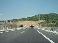 Driskos Tunnel near Ioannina.
 Egnatia Odos (A2) Metsovitikos bridge, as seen from Metsovo
 Near the port of Igoumenitsa
 Egnatia Odos near Ioannina, as seen from Airplane.
 Exit near Kozani
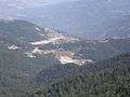 Panoramic view of the tunnel of Malakasi
References
- ↑ Main Road Furniture, Main Tunnel Equipment
- ↑ "Γεφύρι της Αρτας έγινε η Εγνατία οδός". TO BHMA.
- ↑ "Το όνειρο της Εγνατίας έγινε πραγματικότητα". TO BHMA.
- ↑ "Ολοκληρώθηκε και τυπικά η Εγνατία Οδός". ypodomes.com.
- ↑ "Aυτοκινητόδρομος (Aftokinitodromos) A2 - Eγνατια Oδóς (Egnatia Odos)". motorways-exitlists.com.
External links
| Wikimedia Commons has media related to A2 (Greece). |
- The official website of EGNATIA ODOS S.A. (English version)