Adrienne Arsht Center station
Adrienne Arsht Center | |||||||||||
|---|---|---|---|---|---|---|---|---|---|---|---|
| Metromover people mover station | |||||||||||
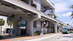 View of the station and a departing Metrobus city bus | |||||||||||
| Location |
1455 Biscayne Boulevard Miami, Florida 33132 | ||||||||||
| Coordinates | 25°47′21″N 80°11′17″W / 25.78917°N 80.18806°WCoordinates: 25°47′21″N 80°11′17″W / 25.78917°N 80.18806°W | ||||||||||
| Owned by | Miami-Dade County | ||||||||||
| Line(s) | |||||||||||
| Platforms | 1 island platform | ||||||||||
| Tracks | 2 | ||||||||||
| Connections |
Private taxicabs | ||||||||||
| Construction | |||||||||||
| Disabled access | Yes | ||||||||||
| Other information | |||||||||||
| Fare zone | |||||||||||
| History | |||||||||||
| Opened | May 26, 1994 | ||||||||||
| Previous names | Omni (1994–2009) | ||||||||||
| Services | |||||||||||
| |||||||||||
Adrienne Arsht Center station, formerly Omni Station, is a Metromover station in the Omni neighborhood of Downtown, Miami, Florida, United States. The station is adjacent to the Adrienne Arsht Center for the Performing Arts, just west of The Miami Herald building and the Venetian Causeway, and directly south of the MacArthur Causeway.
This station is located near the intersection of Northeast 15th Avenue and Biscayne Boulevard (U.S. 1). It opened to service May 26, 1994 as Omni station.
Places of interest
- Omni
- Adrienne Arsht Center for the Performing Arts
- Omni Hotel
- The Grand Doubletree
- Opera Tower
- Platinum on the Bay
- Trinity Episcopal Church
- One Herald Plaza (The Miami Herald Building)
- Miami International University of Art & Design
- Biscayne Bay Marriott International
- Crowne Plaza Hotel
- Hotel Grand Prix
- Quantum Towers
- The Chelsea Tower
- 1490 Biscayne Building
- Soleil Tower and Complex
- Urbana Tower
- Plaza Venetia Hotel
- Miami Beach and Venetian Islands (via MacArthur Causeway and Venetian Causeway)
Transit connections
Metrobus
| Route # | Route Name | Route Map | Note |
|---|---|---|---|
| 3 | Downtown Miami ↔ Aventura Mall via Biscayne Blvd | Map | |
| 10 | The Mall at 163rd Street via NE 2 Ave, North 125 Street, and 12 Ave | Map | Northbound trips only |
| 16 | The Mall at 163rd Street via NE 2 Ave, North 125 Street, and NE 16 Ave | Map | Northbound trips only |
| 32 | To Ives Dairy Road (North 199 St) at 47 Ave via NW 20 St and NW 32 Ave | Map | Northbound trips only |
| 93 | Biscayne MAX (Downtown Miami ↔ Aventura Mall via Biscayne Blvd) | Map | Weekdays only; limited-stop |
| 95 | 95 Express (Golden Glades Park and Ride) via I-95 | Map | Afternoon rush hours only |
| A (101) | Miami Beach at Lincoln Road via Venetian Cswy & 17 St | Map | Eastbound trips only |
| C (103) | Downtown Miami ↔ Miami Beach at Mount Sinai Hospital | Map | |
| M (113) | Civic Center at NW 19 Ave and 20 St ↔ Miami Beach at Mount Sinai Hospital via NW 14 St, Alton Rd, and Collins Ave | Map | |
| S (119) | Downtown Miami ↔ Aventura Mall via Collins Ave | Map | |
| 120 | Beach MAX (Downtown Miami ↔ Aventura Mall via Collins Ave) | Map | |
External links
-
 Media related to Adrienne Arsht Center metro station at Wikimedia Commons
 - MDT – Metromover Stations
- entrance from Google Maps Street View

This article is issued from Wikipedia - version of the 11/21/2016. The text is available under the Creative Commons Attribution/Share Alike but additional terms may apply for the media files.