Civic Center station (Metrorail)
| Metrorail metro station | |||||||||||||||
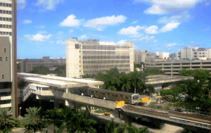
 View from the UM/Jackson medical complex and Metrorail train entering the station | |||||||||||||||
| Location |
1501 NW 12th Avenue, Miami, Florida 33136 | ||||||||||||||
| Coordinates | 25°47′23″N 80°12′54″W / 25.78972°N 80.21500°WCoordinates: 25°47′23″N 80°12′54″W / 25.78972°N 80.21500°W | ||||||||||||||
| Owned by | Miami-Dade County | ||||||||||||||
| Line(s) | |||||||||||||||
| Platforms | 2 side platforms | ||||||||||||||
| Tracks | 2 | ||||||||||||||
| Connections |
| ||||||||||||||
| Construction | |||||||||||||||
| Disabled access | Yes | ||||||||||||||
| Other information | |||||||||||||||
| Station code | CVC | ||||||||||||||
| History | |||||||||||||||
| Opened | December 17, 1984 | ||||||||||||||
| Traffic | |||||||||||||||
| Passengers (2011) |
1.7 million[1] | ||||||||||||||
| Services | |||||||||||||||
| |||||||||||||||
Civic Center is a station of the Metrorail rapid transit system in Miami, Florida's Health District, which is also known as Civic Center. The station is located at the intersection of Northwest 12th Avenue (State Road 933) and 15th Street, opening to service December 17, 1984. Civic Center provides a convenient connection for University of Miami medical students by connecting the hospital area to the main campus at University station. It is also the northernmost station with significant ridership. The rest, including the new Miami Airport Station, altogether average less than 1,700 riders per day each, about a third as much as the average station from Civic Center south.
Places of interest
- Jackson Memorial Hospital
- University of Miami Miller School of Medicine
- Bascom Palmer Eye Institute
- Veterans Hospital
- Marlins Park (1 mile walk south)
- Miami-Dade County Jail
- Miami-Dade Justice Building/Courts
- Florida State Building
- Cedars Medical Center
- Miami-Dade County Health Department
- University of Miami Hospitals and Clinics
Transit connections
Metrobus
| Route # | Route name | Route map | Note |
|---|---|---|---|
| 12 | Northside station ↔ Mercy Hospital via West 12 Ave | Map | |
| 32 | Carol City ↔ Omni at Adrienne Arsht station | Map | |
| 95X | Downtown Miami ↔ Golden Glades via I-95 | Map | Morning southbound and afternoon northbound only |
| M (113) | Civic Center at West 19 Avenue and North 20 Street ↔ Mount Sinai Medical Center & Miami Heart Institute | Map | |
| 246 | Night Owl (Downtown Miami ↔ The Mall at 163rd Street via West 22 Ave) | Map | Overnight service only |
References
- ↑ "(untitled)". Miami-Dade County.
External links
-
 Media related to Civic Center (Metrorail station) at Wikimedia Commons
 - MDT – Metrorail Stations
- entrance from Google Maps Street View
This article is issued from Wikipedia - version of the 11/8/2016. The text is available under the Creative Commons Attribution/Share Alike but additional terms may apply for the media files.
