Aitutaki
|
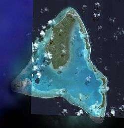
NASA picture of Aitutaki | |
| Geography | |
|---|---|
| Location | Central-Southern Pacific Ocean |
| Coordinates | 18°51′S 159°47′W / 18.85°S 159.79°WCoordinates: 18°51′S 159°47′W / 18.85°S 159.79°W |
| Archipelago | Cook Islands |
| Total islands | 15 |
| Area | 18.05 km2 (6.97 sq mi) |
| Administration | |
| Largest settlement | Arutanga |
| Demographics | |
| Population | 2,194[1] |
Aitutaki, also traditionally known as Araura, Ararau and Utataki, is one of the Cook Islands, north of Rarotonga. It has a population of approximately 2,000. Aitutaki is the second most visited island of the Cook Islands. The main village is Arutanga (Arutunga) on the west side.
Geography
Aitutaki is an "almost atoll". It has a maximum elevation of approximately 123 metres with the hill known as Maunga Pu close to its northernmost point. The land area of the atoll is 18.05 km2 (6.97 sq mi), of which the main island occupies 16.8 km2 (6.5 sq mi).[2] The Ootu Peninsula, protruding east from the main island in a southerly direction along the eastern rim of the reef, takes up 1.75 km2 (0.68 sq mi) out of the main island.[3] For the lagoon, area figures between 50 and 74 km2 (19 and 29 sq mi) are found. Satellite image measurement suggests that the larger figure also includes the reef flat, which is commonly not considered part of a lagoon.
The barrier reef that forms the basis of Aitutaki is roughly the shape of an equilateral triangle with sides 12 kilometres (7.5 mi) in length. The southern edge of the triangle is almost totally below the surface of the ocean, and the eastern side is composed of a string of small islands including Mangere, Akaiami, and Tekopua.
The western side of the atoll contains many of Aitutaki's important features including a boat passage through the barrier reef allowing for anchorage close to shore at Arutanga. Towards the south of the side is a small break in the barrier reef, allowing access for small boats to the lagoon which covers most of the southern part of the triangle. Further to the north is the bulk of the main island. Its fertile volcanic soil provide tropical fruits and vegetables. Two of Aitutaki's 15 islets (motus) are also volcanic. The rest are made of coral.
Aitutaki Airport is located close to the triangle's northern point. There is an area suitable to land flying boats in the southeastern part of the lagoon.
Subdivisions
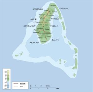
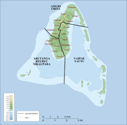
Aitutaki is subdivided in 8 districts. The districts are further subdivided into 19 tapere (land holdings by tribe lineages).
The eight villages are:[5]
- Amuri (Te Upoko Enua)
- Ureia (Uriuri A Punga)
- Arutanga (Rutanga O Te Toa)
- Reureu (Te Mata O Teerui)
- Nikaupara (Te Maru O Toi)
- Vaipae (Te Vaipaepae O Pau)
- Tautu (Titi Ai Tonga)
- Vaipeka (Te Arekarioi)
The eight districts are subdivided into 19 tapere as follows:
- Amuri District
- Amuri Tapere
- Punganui Tapere
- Anaunga District
- Anaunga Tapere
- Punoa Tapere
- Arutanga District
- Arutanga Tapere
- Reureu Tapere
- Nukunoni Tapere
- Ureia Tapere
- Avanui District
- Avanui Tapere
- Vaipeka Tapere
- Taravao District
- Taravao Tapere
- Vaiau Tapere
- Vaiorea Tapere
- Tautu District
- Mataotane Tapere
- Tautu Tapere
- Vaipae District
- Oako Tapere
- Vaipae Tapere
- Vaitupa District
- Taakarere Tapere
- Vaitupa Tapere
History
Polynesians probably first settled Aitutaki around AD 900. The first known European contact was with Captain Bligh and the crew of the HMS Bounty when they discovered Aitutaki on April 11, 1789, prior to the infamous mutiny.
Aitutaki was the first of the Cook Islands to accept Christianity, after London Missionary Society (LMS) missionary John Williams visited in 1821. The oldest church in the country, the Cook Islands Christian Church in Arutanga, was built by Papeiha (Bora Bora) and Vahapata (Raiatea), two LMS teachers Williams had left behind.
On 8-9 October 1900 seven instruments of cession of Rarotonga and other islands were signed by their chiefs and people; and by a British Proclamation issued at the same time the cessions were accepted, the islands being declared parts of Her Britanic Majesty's dominions.[6] Uniquely, these instruments did not include Aitutaki. It appears that, though the inhabitants of Aitutaki regarded themselves as British subjects, the Crown's title was uncertain, and the island was formally annexed by Proclamation dated 9 October 1900.[7][8] It was the only island in the Cook Islands that was annexed rather than ceded.
In 1942 New Zealand and American forces were stationed on the island, building the two-way airstrip that can be seen today. This airport, and one on the northernmost Penrhyn Island, were to be used as bases by the Allies during World War II. The first aircraft, an American light bomber, landed on November 22, 1942. When the war ended some of the servicemen remained and married the locals.
During the 1950s Aitutaki's lagoon was used as a stopover for TEAL (Tasman Empire Airways Limited) flying boats on the famous Coral Route. The islet of Akaiami was used as a resting stop for passengers, who often lay about until the aircraft was refuelled for two hours. These operations ceased in 1960, and the only reminder are the remains of the purpose-built jetty on Akaiami. The flying boat Aranui, which was part of this service, is now on display at the Museum of Transport and Technology in Auckland, New Zealand.
Two of Aitutaki's motus (small islands), Rapota and Moturakau, were the locations of the first series of the UK reality television program Shipwrecked in 2000.
More recently, in 2001, Steve Fossett passed over just south of Aitutaki in the balloon Solo Spirit during his round-the-world trip.
In 2006, the island was used as the location for the tribal council in the US TV program Survivor: Cook Islands. Surrounding islands were used for tribal camps and crew locations. One of the tribes was named Aitutaki (or 'Aitu') after the island.
Then, not long afterwards, Shipwrecked returned again, with Shipwrecked: Battle of the Islands 2006. This was filmed on the same islands as before. One year later, Aitutaki was the locale of an episode of Survivorman.
On February 10–11, 2010, Aitutaki was hit by Cyclone Pat. The high winds of the storm ripped the roofs off of most houses and damaged other buildings including a school and a hospital. At least 60% of houses were damaged. There were no reported deaths but a few minor injuries were reported.[9][10][11] An Air Force Hercules cargo plane and an army engineering team were provided by New Zealand along with an initial $200,000.[12][13] Cook Island MP Teina Bishop said "New Zealand aid should have been sent to the devastated area much sooner.".[14]
|
|
In June 2010 the island was nominated "the world's most beautiful island" by Tony Wheeler the founder of Lonely Planet travel guide.[15]
The delegates of the 2012 Pacific Islands Forum, which had its main venue in Rarotonga, travelled to One Foot Island for a 2-day retreat.[16]
Demographics
The population of Aitutaki is 2,194.[1]
Places of interest
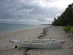
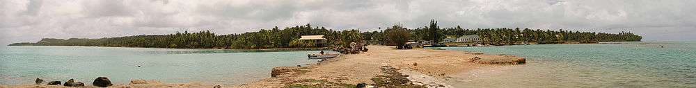
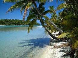
Aitutaki is famous for its turquoise central lagoon, uninhabited islands and palm-fringed beaches. Another advantage is that until now it has been spared by mass tourism. Noteworthy also are an old church (the oldest in the Cook Islands) and some gigantic Banyan trees (Ficus prolixa).
Tapuaetai (One Foot Island), a small islet in the south-east of the lagoon, is often said to be the most important attraction. It is regarded as providing the visitor with the best views of the Aitutaki lagoon and, depending on the tide, one is able to walk on a sandbank a decent distance away from Tapuaetai. The trip to this island is the most frequented trip available on Aitutaki. One Foot Island was awarded "Australasia's Leading Beach" at the World Travel Awards held in Sydney in June 2008.
Air Rarotonga offers daily flights and a day tour from Rarotonga.
Economy
Government jobs are the source of income for the largest number of locals followed closely by tourism. Tourism numbers have started to climb recently with the exposure Aitutaki has been given by travel programmes. The recent addition of a newly built resort has helped to increase tourism numbers.
Sports
The most popular sport on Aitutaki is Rugby union and netball, followed closely by volleyball. With a population of 2,000 residing on the island and 50,000 overseas, there are four clubs on Aitutaki and eight teams (each club having a first team and a reserve team). The best players on the island play for the Aitutaki island team against their main rivals Rarotonga.
Postage stamps
Minor islands of Aitutaki

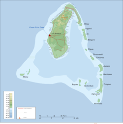
The main island of Aitutaki occupies the northern part of the atoll, which is roughly triangular in shape. The minor islands form part of the perimeter of the lagoon. All islands, including the main island and its peninsula Ootu, are listed starting clockwise from the northernmost point of the atoll:
| Island | Type | Area (ha) | Location |
|---|---|---|---|
| Aitutaki | volcanic main island | 16800 | |
| Ootu | motu peninsula | 175 | |
| Akitua | motu | 14.86 | 18°51′00″S 159°45′25″W / 18.85000°S 159.75694°W |
| Angarei | motu | 13.07 | 18°51′25″S 159°45′12″W / 18.85694°S 159.75333°W |
| Ee (Niura) | motu | 29.21 | |
| Mangere | motu | 8.54 | |
| Papau | motu | 5.26 | |
| Tavaerua Iti | motu | 4.12 | |
| Tavaerua | motu | 12.47 | |
| Akaiami | motu | 41.91 | |
| Muritapua | motu | 4.04 | |
| Tekopua | motu | 71.29 | |
| Tapuaetai (One Foot Island) | motu | 5.96 | |
| Tapuaeta cay | sand cay | 0.95 | |
| Motukitiu | motu | 11.47 | |
| Moturakau | volcanic | 3.86 | |
| Rapota | volcanic | 3.1 | |
| Maina | sand cay | 16.96 | |
| Aitutaki Atoll | near-atoll | 18050 |
Ootu Peninsula is of coral formation, but attached to the main volcanic island, thus a peninsula. If it were an island, it would be the largest of the minor islands. Ootu Peninsula does belong to tapere and district of Vaitupa. The minor islands are not allocated to any districts or tapere, but they do form part of the larger constituencies.
All minor islets, except Akitua and Maina, are part of Vaipae-Tautu Constituency. Akitua is part of Amuri-Ureia Constituency, as is Ootu Peninsula, just north of Akitua. Maina is part of Arutanga-Reureu-Nikaupara Constituency. The main island is equally divided among the three constituencies Arutanga-Reureu-Nikaupara (southwest), Vaipae-Tautu (southeast), and Amuri-Ureia (north).
Education
Araura College is the only secondary school on Aitutaki. The school has the role of teaching approximately 200 students from Year 7 (Form 1) to Year 12 (Form 6).
The island has two government schools and one church school: Araura Primary school, Vaitau Primary School and Tekaaroa Primary School. Tekaaroa Primary School is a private special character school which is the designated Seventh Day Adventist (SDA) school. Araura Primary is the larger of the primary schools, catering for the mostly populated part of the island and Vaitau Primary caters mostly for the Vaipae and Tautu villages. Tekaaroa Primary School caters for the Seventh Day Adventist children on the island.
All schools follow the Cook Islands Curriculum Framework. This is largely based on the New Zealand Curriculum Framework, as most of the young people will eventually migrate to New Zealand to study there at universities or polytechnics. Students from Year 11 (Form 5) and Year 12 (Form 6) are the exception, as they study from the New Zealand Curriculum Framework at NCEA Levels 1, 2 and 3.
References
- 1 2 Aitutaki
- ↑ "Discoverers of the Cook Islands and the Names They Gave — Aitutaki"
- ↑ Atoll Research Bulletin, 190. "Almost-Atoll of Aitutaki: Reef Studies in the Cook Islands", D. R. Stoddard, P. E. Gibbs (eds) August 13, 1975 (12.5 MB)
- ↑ Constitution Amendment (No 11) Act 1982
- ↑ The Parliament of the Cook Islands: Island Government Act 2007
- ↑ "Commonwealth and Colonial Law" by Kenneth Roberts-Wray, London, Stevens, 1966. P. 891
- ↑ "Commonwealth and Colonial Law" by Kenneth Roberts-Wray, London, Stevens, 1966. P. 761
- ↑ N.Z. Parliamentary Pp., A1 (1900)
- ↑ RNZI.com
- ↑ "Wide range of housing in Aitutaki wrecked by Cyclone Pat, but resorts escape damage". Radio New Zealand International. 11 February 2010. Retrieved 19 September 2011.
- ↑ Australianetworknews.com
- ↑ "NZ set to juggle resources in cyclone-hit Pacific". Otago Daily Times. 16 February 2010. Retrieved 16 September 2011.
- ↑ "NZ gives $200k to cyclone-hit Cooks". Television New Zealand. 13 February 2010. Retrieved 16 September 2011.
- ↑ "NZ aid response to Cook cyclone criticised". Television New Zealand. 15 February 2010. Retrieved 16 September 2011.
- ↑ Reuters, 18 June 2010, "Travel Picks: Top places to wed and survive a breakup", Miral Fahmy (ed.); accessed 29 January 2011.
- ↑ "As it happened: Pacific Islands Forum", Radio Australia
External links
| Wikimedia Commons has media related to Aitutaki. |
| Wikivoyage has a travel guide for Aitutaki. |
- Cook Islands website – Aitutaki
- Aitutaki website by a long term resident
- Aitutaki Photo Gallery
- "Aitutaki – One of the World's favourite islands...", Air Rarotonga
- An open access archive collection of index cards of plant and animal names of the Cook Islands at Kaipuleohone includes information on Aitutaki.
| Northern | ||
|---|---|---|
| Southern - Nga-pu-Toru | ||
| Southern - other | ||