Al-Jiftlik
| Al-Jiftlik | |
|---|---|
| Other transcription(s) | |
| • Arabic | الجفتلك |
| • Also spelled |
Al-Jeftlik (official) El-Jeftlak (unofficial) |
|
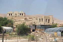
UNRWA school in al-Jiftlik, 2011 | |
 Al-Jiftlik Location of Al-Jiftlik within the Palestinian territories | |
| Coordinates: 32°08′39″N 35°29′36″E / 32.14417°N 35.49333°ECoordinates: 32°08′39″N 35°29′36″E / 32.14417°N 35.49333°E | |
| Governorate | Jericho |
| Government | |
| • Type | Village council |
| • Head of Municipality | Muhammad Omar Jahalin[1] |
| Area | |
| • Jurisdiction | 185,032 dunams (185.0 km2 or 71.4 sq mi) |
| Population (2007) | |
| • Jurisdiction | 3,546 |
Al-Jiftlik (Arabic: الجفتلك) is a Palestinian village in the Jericho Governorate in the West Bank, located 33 kilometers north of Jericho. Al Jiftlik is bordered by the Jordan River to the east. Nearby Palestinian localities include az-Zubaidat to the northeast, Furush Beit Dajan to the northwest, Beit Furik to the west, Aqraba, Majdal Bani Fadil and Duma to the southwest and al-Fasayil to the south.[2] According to the Palestinian Central Bureau of Statistics (PCBS), al-Jiftlik had a population of 3,546 in the 2007 census.
The village's total area amounts to 185,032 dunams, of which 972 dunams are Palestinian built up areas, 77 are for commercial and industrial transport units, 64,032 are arable lands and 108,606 dunams are open spaces. Israeli settlements, including Massua, Hamra and Argaman and military bases account for 11,293 dunams.[2] The remaining land consists of forests and inland water.[2]
History
The majority of the land in al-Jiftlik belonged to the al-Masa'id tribe, a powerful Bedouin family whose land spanned from Damia in Transjordan, on the east bank of the Jordan River, to the borders of Jericho in the West Bank. Most of its residents are descendants of the al-Masa'id tribe and immigrants from Tammun to the north.[2]
The village's name is derived from the Turkish word chiflik, the term for "land tenure" in the late Ottoman Empire which was applied in this as in many other Ottoman locations.[3] It received its name due to the agricultural nature of the village.[2] During the mandate period, there was a Tegart fort known as the Jiftlik Police Post just west of the present village.[3]
The West Bank was occupied by Israel during the Six-Day War in 1967 and in the aftermath of the conflict over 800 homes in al-Jiftlik were razed by the Israeli army and its 6,000 inhabitants were ordered to leave. Most of al-Jiftlik's inhabitants, however, returned to the village.[4] After the 1993 Oslo Accords between the Israel and the Palestine Liberation Organization (PLO), the village was designated as part of Area C. This makes it subject to full Israeli military and civil administration.[2]
In 2005 a village council was established to administer local affairs. Its nine members are appointed by the Palestinian National Authority. The council maintains a permanent headquarters and owns a waste collection vehicle. Among its responsibilities are building water and electricity networks in al-Jiftlik and providing an ambulance for the village.[2]
Demographics
In the 2007 census al-Jiftlik had a population of 3,546 with exactly 50% being males and the other 50% females. The total number of households was 578 who lived in 692 housing units. The principal clans in al-Jiftlik are the 'Arab al-Masa'id, 'Arab al-Jahalin, 'Arab al-Ayed, al-Ajajrah, Abu Sureis, Abu Dalakh, Abu Dheila, al-Annuz, al-Rutimat and al-Nafei'at. According to the Applied Research Institute-Jerusalem (ARIJ), about 100 families have left al-Jiftlik since the start of the Second Intifada in 2000.[2]
Economy and education
Like several other villages in the Jordan Valley area, al-Jiftlik is subject to Israeli restrictions on construction and movement, and most often requests for building permits are denied. The village lacks electricity and water infrastructure.[5] It has primary school managed by the UNRWA with 950 students.
Id'eis
Id'eis is a Palestinian community several kilometres south of Al-Jiftlik, close to the Masua Israeli settlement. In May 2014, there were 23 families in two neighboring compounds made up of 13 families consisting of 75 people in 15 residential structures living in the north-west compound and 10 families consisting of 53 people living in 14 tents in the southern compound. Each compound also has many livestock structures for their flocks of several thousand sheep and goats. The community makes its living from shepherding and settled in the present location in 1982 having left the Hebron area and migrated across the Jordan Valley as they searched for pastureland. On 21 May 2014, the southern compound was demolished by five Israeli Civil Administration bulldozers supported by IDF soldiers and Border Police on the basis that the families did not have building permits.[6]
References
| Wikimedia Commons has media related to Al-Jiftlik. |
- ↑ West Bank Local Elections ( Round two)- Successful candidates by local authority, gender and No. of votes obtained, al-Jftalak p 23
- 1 2 3 4 5 6 7 8 Al Jiftlik Village Profile. Applied Research Institute-Jerusalem (ARIJ). 2012.
- 1 2 Roza El-Eini (2006). Mandated landscape : British imperial rule in Palestine, 1929-1948. Routledge. p. 486. ISBN 978-0-7146-5426-3.
- ↑ Karmi, Ghada (1999). The Palestinian Exodus, 1948-1998. University of London, Centre of Islamic and Middle Eastern Law. Garnet & Ithaca Press. p.90. ISBN 0-86372-244-X.
- ↑ Aid agencies tread gingerly in Area C. Ma'an News Agency. 2013-1-13.
- ↑ "Civil Administration demolishes nearly half the homes in community of Id'eis, the Jordan Valley". B'tselem. 29 May 2014.
External links
External links
- Survey of Western Palestine, Map 15: IAA, Wikimedia commons
| Cities |  | |
|---|---|---|
| Municipalities | ||
| Villages |
| |
| Refugee camps | ||