Alamo, Nevada
| Alamo, Nevada | |
|---|---|
| Town | |
 | |
 Alamo Location withihn the state of Nevada | |
| Coordinates: 37°21′54″N 115°09′52″W / 37.36500°N 115.16444°WCoordinates: 37°21′54″N 115°09′52″W / 37.36500°N 115.16444°W | |
| Country | United States |
| State | Nevada |
| County | Lincoln |
| Area | |
| • Total | 30.3 sq mi (78.4 km2) |
| • Land | 30.3 sq mi (78.4 km2) |
| • Water | 0 sq mi (0 km2) |
| Elevation | 3,449 ft (1,051 m) |
| Population (2010) | |
| • Total | 1,080 |
| • Density | 36/sq mi (14/km2) |
| Time zone | Pacific (PST) (UTC-8) |
| • Summer (DST) | PDT (UTC-7) |
| ZIP codes | 89001 |
| FIPS code | 32-00500 |
| GNIS feature ID | 0845339 |
Alamo is a town in Lincoln County, Nevada, United States, about 90 miles (140 km) north of Las Vegas along U.S. Route 93. Its elevation is 3,449 feet (1,051 m). As of the 2010 census it had a population of 1,080.[1] Founded in 1901, Alamo is named after the Spanish word for "poplar" due to the localized presence of that type of tree.
Geography
Alamo lies in the Pahranagat Valley. Its economy is dependent primarily upon ranching. The closest attraction is the Pahranagat National Wildlife Refuge.[2]
Between Alamo and the town of Rachel is the site of the Devonian Alamo Impact Breccia.[3]
According to the U.S. Census Bureau, the Alamo CDP has an area of 30.3 square miles (78.4 km2), all of it land.[1]

Tourism
Alamo attracts tourists and truckers traveling from Las Vegas to northern Nevada and Idaho. Attractions include the nearby warm springs, wildlife refuge, Extraterrestrial Highway and Area 51. Gas stations in Alamo cater to these tourists by offering alien memorabilia. There are two truck stops, the Alamo Sinclair, the Ash Springs Shell, that offer large diesel filling areas to attract passing truckers. There are also four motels in Alamo, the Alamo Inn, Sunset View Inn, Windmill Ridge, and A Cowboy's Dream.
Transportation
Education
Public education is provided by the Lincoln County School District, with offices in Panaca, Nevada. There are three schools in the valley.
| School | Grades |
|---|---|
| Pahranagat Valley Elementary School | K–5 |
| Pahranagat Valley Middle School | 6-8 |
| Pahranagat Valley High School | 9-12 |
Religion
There are three different religious denominations with churches in Alamo:
- Christian Bible Fellowship Church
- The Church of Jesus Christ of Latter-day Saints, who were early settlers of this area
- Trinity Assembly of God
Services
Alamo has a police force, a volunteer fire department, phone and internet services, a medical clinic, and a public library. Nevada Bank and Trust offers financial services to residents. Alamo's first radio station, KQLN 91.3 FM, went on the air on November 17, 2010, but the station's license was cancelled at licensee's request, effective on July 2, 2013.
Climate
| Climate data for Alamo, Nevada (Elevation 3,449ft) | |||||||||||||
|---|---|---|---|---|---|---|---|---|---|---|---|---|---|
| Month | Jan | Feb | Mar | Apr | May | Jun | Jul | Aug | Sep | Oct | Nov | Dec | Year |
| Record high °F (°C) | 76 (24) |
83 (28) |
85 (29) |
95 (35) |
105 (41) |
112 (44) |
114 (46) |
116 (47) |
108 (42) |
100 (38) |
86 (30) |
76 (24) |
116 (47) |
| Average high °F (°C) | 51.2 (10.7) |
56.3 (13.5) |
64.5 (18.1) |
74.4 (23.6) |
82.9 (28.3) |
93.1 (33.9) |
100.1 (37.8) |
96.5 (35.8) |
90.3 (32.4) |
77.9 (25.5) |
64.2 (17.9) |
54.2 (12.3) |
75.5 (24.2) |
| Average low °F (°C) | 21.2 (−6) |
25.4 (−3.7) |
29.6 (−1.3) |
36.6 (2.6) |
42.9 (6.1) |
49.8 (9.9) |
57.3 (14.1) |
55.5 (13.1) |
46.3 (7.9) |
37.5 (3.1) |
28.3 (−2.1) |
23.7 (−4.6) |
37.9 (3.3) |
| Record low °F (°C) | −9 (−23) |
−6 (−21) |
11 (−12) |
14 (−10) |
20 (−7) |
25 (−4) |
40 (4) |
33 (1) |
24 (−4) |
11 (−12) |
7 (−14) |
0 (−18) |
−9 (−23) |
| Average precipitation inches (mm) | 0.65 (16.5) |
0.64 (16.3) |
0.69 (17.5) |
0.56 (14.2) |
0.49 (12.4) |
0.16 (4.1) |
0.57 (14.5) |
0.71 (18) |
0.27 (6.9) |
0.53 (13.5) |
0.45 (11.4) |
0.55 (14) |
6.27 (159.3) |
| Average snowfall inches (cm) | 3.6 (9.1) |
1.2 (3) |
0.8 (2) |
0.3 (0.8) |
0.1 (0.3) |
0 (0) |
0 (0) |
0 (0) |
0 (0) |
0 (0) |
0.2 (0.5) |
1.3 (3.3) |
7.4 (18.8) |
| Source: The Western Regional Climate Center[4] | |||||||||||||
References
- 1 2 "Geographic Identifiers: 2010 Demographic Profile Data (G001): Alamo CDP, Nevada". U.S. Census Bureau, American Factfinder. Retrieved January 25, 2013.
- ↑ Lincoln County Website, Alamo
- ↑ A Short History of Rachel, Nevada
- ↑ "Seasonal Temperature and Precipitation Information". Western Regional Climate Center. Retrieved April 12, 2013.
| Wikimedia Commons has media related to Alamo, Nevada. |
Municipalities and communities of Lincoln County, Nevada, United States | ||
|---|---|---|
| Cities | 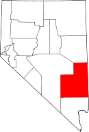 | |
| CDPs | ||
| Other unincorporated communities | ||
| Ghost towns | ||
| Footnotes | ‡This populated place also has portions in an adjacent county or counties | |