Alejandro de Humboldt National Park
| Alejandro de Humboldt National Park | |
|---|---|
|
IUCN category II (national park) | |
|
Alejandro de Humboldt National Park | |
 Location in Cuba | |
| Location | Cuba |
| Nearest city | Guantánamo |
| Coordinates | 20°27′00″N 75°00′00″W / 20.45000°N 75.00000°WCoordinates: 20°27′00″N 75°00′00″W / 20.45000°N 75.00000°W |
| Area | 711.38 km2 (274.67 sq mi)[1] |
| Type | Natural |
| Criteria | ix, x |
| Designated | 2001 (25th session) |
| Reference no. | 839 |
| State Party | Cuba |
| Region | Latin America and the Caribbean |
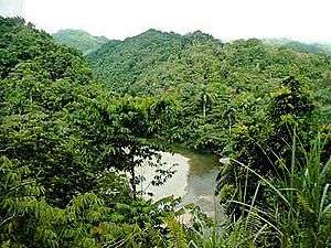
Alejandro de Humboldt National Park (Spanish: Parque Nacional Alejandro de Humboldt) is a national park in the Cuban provinces of Holguín and Guantánamo. It is named after the German scientist Alexander von Humboldt who visited the island in 1800 and 1801. The park was inscribed as a UNESCO World Heritage Site in 2001 for of its size, altitude range, complex lithology, landform diversity, and wealth of endemic flora and fauna.
Overview
The rivers that flow off the peaks of the park are some of the largest in the insular Caribbean. The park is said to be the most humid place in Cuba[2] and this causes a high biological diversity. The park has an area of 711.38 km2 (274.67 sq mi),[1] of which 685.72 km2 (264.76 sq mi) land area and 22.63 km2 (8.74 sq mi) marine area. Elevation ranges from sea level to 1,168 m (3,832 ft) on El Toldo Peak.
16 of Cuba's 28 endemic plant species are protected in the park including such fauna as Dracaena cubensis and Podocarpus ekman. Fauna present in the park includes various species of parrots, lizards, hummingbirds, the endangered Cuban solenodon (endemic), hutia and snails.
History
The Alexander von Humboldt National Park has historically been an area of land little used by man, with only one archaeological site from the pre-Columbian period being known; this is located in the coastal zone of Aguas Verdes. During the eighteenth and nineteenth centuries some peripheral places were used as refuges or camps by maroons.
The park began to be laid out in the 1960s, with the declaration of the Jaguani and Cupeyal del Norte nature reserves. This continued into the 1980s with the proposal of the Ojito del Agua Refuge, associated with the last sighting of the royal woodpecker, a last remnant of this species which was already extinct in its other habitats in the United States and Mexico. In 1996 these protected areas were united to form a national park that was named after Alexander von Humboldt. Being one of the most important biosphere reserves in the Caribbean basin, the national park, along with Cuchillas del Toa was declared a UNESCO World Natural Heritage Site in 2001.
There are unique flora and fauna elements in this unique ecosystem, with some of the highest indexes of endemicity in the archipelago.
References
- 1 2 National Protected Areas System of Cuba (2005). "Protected Areas". Retrieved 2009-07-09.
- ↑ Radio Habana. "Parque Nacional Alejandro de Humboldt" (in Spanish). Archived from the original on 2007-10-05. Retrieved 2007-10-10.
External links
| Wikivoyage has a travel guide for Alejandro de Humboldt National Park. |
Protected areas of Cuba | ||
|---|---|---|
| National parks | ||
| World heritage sites | ||
| Biosphere reserves | ||