Cienfuegos
| Cienfuegos | ||
|---|---|---|
| Municipality | ||
|
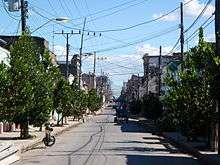
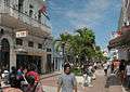
Typical street in Cienfuegos | ||
| ||
| Nickname(s): La Perla del Sur (Pearl of the South) | ||
.png) Cienfuegos municipality (red) within Cienfuegos Province (yellow) and Cuba | ||
 Location of Cienfuegos in Cuba | ||
| Coordinates: 22°08′44″N 80°26′11″W / 22.14556°N 80.43639°WCoordinates: 22°08′44″N 80°26′11″W / 22.14556°N 80.43639°W | ||
| Country | Cuba | |
| Province | Cienfuegos | |
| Founded | 1819[1] | |
| Area[2] | ||
| • Total | 333 km2 (129 sq mi) | |
| Elevation | 25 m (82 ft) | |
| Population (2012)[3] | ||
| • Total | 164,924 | |
| • Density | 500/km2 (1,300/sq mi) | |
| Demonym(s) | Cienfuegueros | |
| Time zone | EST (UTC-5) | |
| Postal code | 55100-55500 | |
| Area code(s) | +53 43 | |
| Vehicle registration | CF | |
.jpg)
Cienfuegos (American Spanish: [sjeɱˈfweɣos]), capital of Cienfuegos Province, is a city on the southern coast of Cuba.[4] It is located about 250 km (160 mi) from Havana and has a population of 150,000. The city is dubbed La Perla del Sur (Pearl of the South). Cienfuegos literally translates to "one hundred fires"—cien meaning "one hundred", fuegos meaning "fires".
History
The area where the city lies was identified as Cacicazgo de Jagua by early Spanish conquistadors. It was originally settled by Taino indigenous people. Cacicazgo translates from the Taino language as "chiefdom". Cacicazgo de Jagua was therefore the chiefdom of Chief Jagua.
The city was later settled by French immigrants from Bordeaux and Louisiana led by Don Louis de Clouet on April 22, 1819.[1] The settlers named the city Fernandina de Jagua in honor of King Ferdinand VII of Spain and Chief Jagua.[5] The settlement successively became a town (villa) in 1829, renamed for José Cienfuegos, Captain General of Cuba (1816–19), and a city in 1880. Many of the streets in old town reflect French origins in their names: Bouyón, D'Clouet, Hourruitiner, Gacel, and Griffo, for instance.
Cienfuegos port, despite being one of the latest settlements established during the colonial era, soon grew to be a powerful town due to the fertile fields surrounding it and its position on the trade route between Jamaica and South American cities to the southeast and the hinterland provincial capital of Santa Clara to the northeast. Its advantageous trading location on the historically eponymous Bay of Jagua was used by the Cuban sugar oligarchy when a railroad was built between both cities between 1853 and 1860.[6][7]
Near Cienfuegos was the scene of a battle during the Spanish–American War on May 11, 1898, between American Marines attempting to sever underwater Spanish communication lines and the Spanish defenders.
During the Cuban Revolution, the city saw an uprising against Fulgencio Batista and was bombed in retaliation on September 5, 1957.[8]
In 1969 and 1970, Soviet naval vessels visited the city. This appeared to be in violation of the Kennedy-Khrushchev agreements of 1962. However, there was no notice given by the United States and no confrontation ensued.[9]
Hurricane Dennis 2005
In 2005, Hurricane Dennis made its second landfall near Cienfuegos at about 1:00PM AST (17:00 UTC) with winds of 232 km/h (144 mph) and gusts reaching 285 km/h (177 mph).
Geography
Near the entrance to Cienfuegos Bay is Castillo de Jagua (full name: Castillo de Nuestra Señora de los Angeles de Jagua), a fortress erected in 1745 for protection against Caribbean pirates.
Cienfuegos, one of the chief seaports of Cuba, is a center of the sugar trade as well as coffee and tobacco. While sugarcane is the chief crop, local farmers also grow coffee.
Demographics
In 2004, the municipality of Cienfuegos had a population of 163,824.[3] With a total area of 333 km2 (129 sq mi),[2] it has a population density of 492.0/km2 (1,274/sq mi).
Climate
According to the Köppen Climate Classification system, Cienfuegos has a tropical savanna climate, abbreviated "Aw" on climate maps.
| Climate data for Cienfuegos | |||||||||||||
|---|---|---|---|---|---|---|---|---|---|---|---|---|---|
| Month | Jan | Feb | Mar | Apr | May | Jun | Jul | Aug | Sep | Oct | Nov | Dec | Year |
| Record high °C (°F) | 31.1 (88) |
32.8 (91) |
33.3 (91.9) |
32.8 (91) |
34.4 (93.9) |
35.0 (95) |
35.0 (95) |
34.4 (93.9) |
35.0 (95) |
33.9 (93) |
32.8 (91) |
31.7 (89.1) |
35.0 (95) |
| Average high °C (°F) | 27.2 (81) |
27.8 (82) |
28.9 (84) |
29.4 (84.9) |
30.6 (87.1) |
31.7 (89.1) |
32.2 (90) |
32.2 (90) |
31.7 (89.1) |
31.1 (88) |
28.3 (82.9) |
27.8 (82) |
29.9 (85.8) |
| Daily mean °C (°F) | 22.2 (72) |
22.3 (72.1) |
23.4 (74.1) |
24.4 (75.9) |
25.6 (78.1) |
26.7 (80.1) |
27.2 (81) |
27.2 (81) |
26.7 (80.1) |
26.7 (80.1) |
23.9 (75) |
22.8 (73) |
24.9 (76.8) |
| Average low °C (°F) | 17.2 (63) |
16.7 (62.1) |
17.8 (64) |
19.4 (66.9) |
20.6 (69.1) |
21.7 (71.1) |
22.2 (72) |
22.2 (72) |
21.7 (71.1) |
21.7 (71.1) |
19.4 (66.9) |
17.8 (64) |
19.9 (67.8) |
| Record low °C (°F) | 7.8 (46) |
7.2 (45) |
7.2 (45) |
10.0 (50) |
13.3 (55.9) |
18.9 (66) |
20.0 (68) |
19.4 (66.9) |
20.0 (68) |
15.6 (60.1) |
11.1 (52) |
8.9 (48) |
7.2 (45) |
| Average rainfall mm (inches) | 18 (0.71) |
25 (0.98) |
33 (1.3) |
46 (1.81) |
119 (4.69) |
152 (5.98) |
122 (4.8) |
160 (6.3) |
173 (6.81) |
160 (6.3) |
41 (1.61) |
23 (0.91) |
1,072 (42.2) |
| Source: Sistema de Clasificación Bioclimática Mundial[10] | |||||||||||||
World Heritage Site
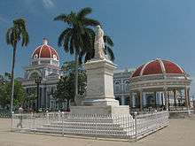
In 2005, UNESCO inscribed the Urban Historic Centre of Cienfuegos on the World Heritage List, citing Cienfuegos as the best extant example of early 19th century Spanish Enlightenment implementation in urban planning.[11]
The downtown area contains 6 buildings from 1819–50, 327 buildings from 1851–1900, and 1188 buildings from the 20th century. There is no other place in the Caribbean which contains such a remarkable cluster of Neoclassical structures.
Sports
Cienfuegos fields a team in the Cuban National Series, the Cienfuegos Elefantes. Since joining the league in 1977–78, the best finish the Camaroneros have achieved is a 3rd place showing in the 2010–11 Cuban National Series. Despite finishing with the best record at 59–31, the Elefantes lost the semifinals in six games to the eventual champions, the Pinar del Río Vegueros.
Attractions
- Castillo de Nuestra Señora de los Ángeles de Jagua – fortress
- Arco de Triunfo – the only Arco de Triunfo in Cuba
- Cathedral de la Purisma Concepción – cathedral with stained glass work, built 1833–1869.
- Delfinario – dolphins and sea lions in a saltwater lagoon
- Jardín Botánico de Cienfuegos – 97 hectares of botanic garden
- Museo Provincial – furniture and porcelain museum
- Palacio de Valle – built 1913–1917 in neo-gothic style
- Palmira Yorubá Pantheon – museum of religious afro-catholic syncretism
- Parque José Martí – park in Plaza de Armas
- University of Cienfuegos "Carlos Rafael Rodríguez" (UCF) – the province's secondary education institution.
- Rancho Luna Beach

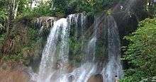
- Nicho
Famous residents
- Benny Moré, Cuban singer.
- Cristóbal Torriente, Cuban-born Hall of fame Baseball player.
- Gina Pellón, Cuban painter, lives in exile in Paris.
- María Conchita Alonso, Cuban-Venezuelan-American singer was born here.
- Luis Posada Carriles, Cuban anti-Castro activist believed to be responsible for the Cubana Flight 455 bombing, was born here.
- Joe Azcue, MLB player for the Cincinnati Reds, Kansas City Royals, Cleveland Indians, Boston Red Sox, California Angels, and the Milwaukee Brewers
- Yasiel Puig, MLB player for the Los Angeles Dodgers, was born here.
- Yordany Álvarez, MLS player for Real Salt Lake
- José Abreu, MLB player for the Chicago White Sox.
- Luis Alberto Pérez Copperi, Cuban artist.
Sister Cities
Cienfuegos has the following sister cities:
-
 Tacoma, Washington United States
 -
 Etzatlán, Mexico[12][13]
 - Cambridge, Massachusetts, United States
-
 Kingston, Ontario, Canada (2005)
 -
 Bahía Blanca, Argentina
 -
 Saint-Nazaire, France
 -
 Contagem, Brazil
Gallery
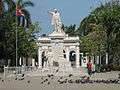 Statue of José Martí
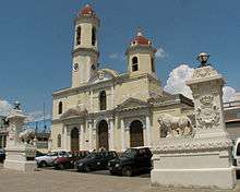 Cathedral of Cienfuegos and Medici Lions
.jpg) Statue of Benny More
Statue of Benny More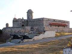
 Pedestrian Boulevard
 Prado
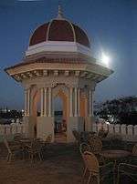
Prado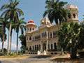 Palacio de Valle (Valle's Palace) in Punta Gorda
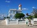 Palacio Azul (Blue Palace)
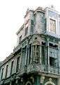 Closeup of porthouse
 The yacht club in Cienfuegos
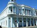 Historical building in Spanish Colonial architecture
 The Promenade of Cienfuegos
.jpg) The central Calle D'Clouet with the "Hotel La Unión" (left) and the railtrack remains of the former urban tramway.
The central Calle D'Clouet with the "Hotel La Unión" (left) and the railtrack remains of the former urban tramway.
See also
References
- 1 2 Guije.com. "Cienfuegos" (in Spanish). Retrieved 2007-10-07.
- 1 2 Statoids (July 2003). "Municipios of Cuba". Retrieved 2007-10-07.
- 1 2 Atenas.cu (2004). "2004 Population trends, by Province and Municipality" (in Spanish). Archived from the original on 2007-09-27. Retrieved 2007-10-07.
- ↑
 Chisholm, Hugh, ed. (1911). "Cienfuegos". Encyclopædia Britannica. 6 (11th ed.). Cambridge University Press. p. 364.
 - ↑ Ojeda Cabrera, Mireya. "Cienfuegos a 190 años de fundada" (in Spanish). Radio Rebelde. Retrieved 23 September 2016.
- ↑ Santa Clara railway station (Cuba)
- ↑ Zanetti Lecuona, Oscar; García Alvarez, Alejandro (27 June 2002). Sugar & Railroads: A Cuban History, 1837-1959. Scholarly Book Services Inc. pp. 51–53. ISBN 978-0807846926.
- ↑ Castro speech commemorates Moncada assault
- ↑
- ↑ "Cuba–Cienfuegos". Centro de Investigaciones Fitosociológicas. Retrieved June 14, 2015.
- ↑ Cienfuegos at World Heritage List
- ↑ http://www.sre.gob.mx/gobiernoslocales/
- ↑ http://www.sre.gob.mx/coordinacionpolitica/images/stories/documentos_gobiernos/rai/jal/jal40.pdf
External links
| Wikimedia Commons has media related to Cienfuegos. |
| Wikisource has the text of The New Student's Reference Work article Cienfuegos. |
 Cienfuegos travel guide from Wikivoyage
- Guide of Cienfuegos
- Photo collections with most the city's landmarks on Flickr
| Current | |||||||||
|---|---|---|---|---|---|---|---|---|---|
| Historical | |||||||||
| Provincial capitals | |||||||||
| |||||||||
Protected areas of Cuba | ||
|---|---|---|
| National parks | ||
| World heritage sites | ||
| Biosphere reserves | ||