Allithwaite


Coordinates: 54°10′49″N 2°56′23″W / 54.1802°N 2.9398°W
Allithwaite is a small village in Cumbria, England, located roughly 1.2 miles (1.9 km) west of Grange-over-Sands. Most of its residents commute to local areas of Ulverston, Barrow-in-Furness, Kendal or Lancaster to work. Historically in Lancashire, Allithwaite, and the village of Cartmel situated to the north, are part of the civil parish of Lower Allithwaite. At the 2001 census, the parish had a population of 1,758, increasing to 1,831 at the 2011 Census.[1] There is also a civil parish called Upper Allithwaite, which includes Lindale and Low and High Newton. The population of this parish at the 2011 Census was 843.[2]
The Anglican parish church is St. Mary's Church, built in 1864–65 and designed by the Lancaster architect E. G. Paley. There is a small primary school, Allithwaite Primary C of E School located next to the church. Both church and school were built by a legacy left to the village. The village also has two pubs, a post office, a children's playground and a reasonably sized playing field with a tennis court and a bowling green.
According to recent surveys Allithwaite has no air pollution.
Wraysholme Tower
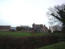
A mile to the south, Wraysholme Tower is a 15th-century pele tower, used as a barn and cow-house, adjoining a 19th-century farmhouse.[3] The tower was built by the Harrington family of Aldingham. A Michael Harrington acquired a grant of free warren in Allingham in 1315. The tower is 40 feet (12 m) by 28 feet (8.5 m). It has axes north and south and is built of local limestone rubble, with angle quoins. The walls are 4 feet (1.2 m) thick at their base. There is a projecting garderobe, about 7 feet (2.1 m) square, at the south-west corner, where there is a spiral staircase. There was originally an entrance at the north-west corner.[4] The building is roofed with slate.[5][6]
References
- ↑ "Parish population 2011". Retrieved 12 June 2015.
- ↑ "Upper Allithwaite Civil Parish population 2011". Retrieved 25 January 2016.
- ↑ "Wraysholme Tower". britishlistedbuildings.co.uk. Retrieved 8 March 2011.
- ↑ Leslie Irving Gibson (1977). Lancashire Castles and Towers. Clapham, North Yorkshire: Dalesman Books. p. 48.
- ↑ "Wraysholme Tower". Visit Cumbria. Retrieved 5 July 2015.
- ↑ The Cumbrian Castle listing. (4 June 2006). "The castles, towers and fortified buildings of Cumbria: Wraysholme Tower, Allithwaite". Matthewpemmott.co.uk. Retrieved 5 July 2015.
External links
 Media related to Allithwaite at Wikimedia Commons
- Cumbria County History Trust: Allithwaite, Lower (nb: provisional research only - see Talk page)
- Cumbria County History Trust: Allithwaite, Upper (nb: provisional research only - see Talk page)
- Allithwaite C of E Primary School