Alore
| Alore | |
|---|---|
| city | |
 | |
 Alore  Alore Location in Maharashtra, India | |
| Coordinates: 17°28′N 73°37′E / 17.47°N 73.62°ECoordinates: 17°28′N 73°37′E / 17.47°N 73.62°E | |
| Country |
|
| State | Maharashtra |
| District | Ratnagiri |
| Elevation | 73.2 m (240.2 ft) |
| Population (2006) | |
| • Total | 5,315 |
| Languages | |
| • Official | Marathi |
| Time zone | IST (UTC+5:30) |
| PIN | 415 603 |
| Telephone code | 02355 |
| Vehicle registration | MH-08 |

A tributary of the Vashishti River near Alore
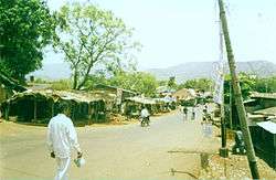
Alore is a village in the Chiplun subdivision of Ratnagiri district, Maharashtra, India. It lies on a bypass of the state highway linking Chiplun to Karad.
Alore has many facilities such as a hospital, reputed school, engineering college, market area, net cafe, continuous electricity, eat outs. This is happened because of the Irrigation department offices present in the town. Koyna Dam Maintenance Division (KDMD) has its main base in Alore.
A government guesthouse is the only lodging in this village. It is located 12 kilometres east of Chiplun, the nearest town. Marathi is the most common language spoken here.
References
This article is issued from Wikipedia - version of the 8/24/2016. The text is available under the Creative Commons Attribution/Share Alike but additional terms may apply for the media files.