Alykes
For other uses, see Alykes (disambiguation).
| Alykes Αλυκές | |
|---|---|
|
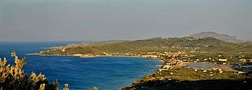
Bay of Alykes looking south showing the village of Alykes nearest (with the salt flats to the right) with Alikanas beyond. | |
 Alykes | |
|
Location within the regional unit 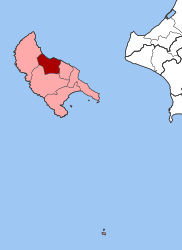 | |
| Coordinates: 37°50′N 20°46′E / 37.833°N 20.767°ECoordinates: 37°50′N 20°46′E / 37.833°N 20.767°E | |
| Country | Greece |
| Administrative region | Ionian Islands |
| Regional unit | Zakynthos |
| Municipality | Zakynthos |
| • Municipal unit | 42.9 km2 (16.6 sq mi) |
| Population (2011)[1] | |
| • Municipal unit | 5,203 |
| • Municipal unit density | 120/km2 (310/sq mi) |
| Time zone | EET (UTC+2) |
| • Summer (DST) | EEST (UTC+3) |
| Vehicle registration | ZA |
| Website | www.alykes.gr |
Alykes (Greek: Αλυκές) is a former municipality on the island of Zakynthos, Ionian Islands, Greece. Since the 2011 local government reform it is part of the municipality Zakynthos, of which it is a municipal unit.[2] It is situated along the northeastern coast of the island, about 10 km (6.2 mi) northwest of Zakynthos (city). It has a land area of 42.881 km2 (16.6 sq mi)[3] and a population of 5,203 (2011 census).[1] The seat of the municipality was in Katastari (pop. 1,378). The next largest towns in the municipality are Skoulikádo (pop. 653), Agios Dimitrios (531), Pigadákia (431), Alikanas (441), and Káto Gerakári (347).
Subdivisions
The municipal unit Alykes is subdivided into the following communities (constituent villages in brackets):[2]
- Agios Dimitrios (Agios Dimitrios, Drakas)
- Alikanas
- Ano Gerakari (Ano Gerakari, Alonia, Kastelia)
- Katastari
- Kallithea
- Kato Gerakari
- Meso Gerakari (Meso Gerakari, Psarou)
- Pigadakia
- Skoulikado
Population
| Year | Population |
|---|---|
| 1991 | 4,313 |
| 2001 | 4,796 |
| 2011 | 5,203 |
References
- 1 2 "Απογραφή Πληθυσμού - Κατοικιών 2011. ΜΟΝΙΜΟΣ Πληθυσμός" (in Greek). Hellenic Statistical Authority.
- 1 2 Kallikratis law Greece Ministry of Interior (Greek)
- ↑ "Population & housing census 2001 (incl. area and average elevation)" (PDF) (in Greek). National Statistical Service of Greece.
 |
Ionian Sea | | ||
| Elatia | |
Arkadioi | ||
| ||||
| | ||||
| Artemisia |
External links
- Official website (Greek)
This article is issued from Wikipedia - version of the 12/1/2016. The text is available under the Creative Commons Attribution/Share Alike but additional terms may apply for the media files.