Ames Creek (South Santiam River)
| Ames Creek | |
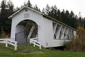 Weddle Bridge over Ames Creek in Sankey Park | |
| Country | United States |
|---|---|
| State | Oregon |
| County | Linn |
| Source | Cascade Range foothills |
| - location | near Chimney Rock |
| - elevation | 2,020 ft (616 m) [1] |
| - coordinates | 44°19′43″N 122°40′40″W / 44.32861°N 122.67778°W |
| Mouth | South Santiam River |
| - location | Sweet Home |
| - elevation | 551 ft (168 m) [2] |
| - coordinates | 44°23′33″N 122°43′28″W / 44.39250°N 122.72444°WCoordinates: 44°23′33″N 122°43′28″W / 44.39250°N 122.72444°W [2] |
 Location of the mouth of Ames Creek in Oregon
| |
Ames Creek is a small tributary of the South Santiam River in the U.S. state of Oregon. It begins near Chimney Rock in the foothills of the Cascade Range in Linn County. It flows northwest to meet the river at Sweet Home, about 33 miles (53 km) by river from the South Santiam's confluence with the Santiam River. Ames Creek passes under U.S. Route 20 just before entering the river.[3]
Covered bridge
Weddle Bridge, a covered bridge, spans the creek in Sankey Park in Sweet Home.[4] The bridge originally spanned Thomas Creek elsewhere in Linn County but was rebuilt over Ames Creek in 1989.[4]
See also
References
- ↑ Source elevation derived from Google Earth search using GNIS source coordinates.
- 1 2 "Ames Creek". Geographic Names Information System. United States Geological Survey. November 28, 1980. Retrieved March 28, 2016.
- ↑ "United States Topographic Map". United States Geological Survey. Retrieved March 28, 2016 – via Acme Mapper. The map includes mile markers along the South Santiam River.
- 1 2 "Ames Creek (Weddle) Covered Bridge" (PDF). Oregon Department of Transportation. Retrieved March 28, 2016.
External links
This article is issued from Wikipedia - version of the 9/11/2016. The text is available under the Creative Commons Attribution/Share Alike but additional terms may apply for the media files.