Sweet Home, Oregon
| Sweet Home, Oregon | |
|---|---|
| City | |
|
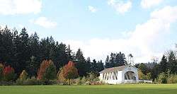
The Weddle Bridge spans Ames Creek in Sweet Home, Oregon. | |
| Nickname(s): Gateway to the Santiam Playground | |
| Motto: Sweet Home: Oregon at its Best | |
 Location in Oregon | |
| Coordinates: 44°24′2″N 122°42′57″W / 44.40056°N 122.71583°WCoordinates: 44°24′2″N 122°42′57″W / 44.40056°N 122.71583°W | |
| Country | United States |
| State | Oregon |
| County | Linn |
| Incorporated | 1893 |
| Government | |
| • Mayor | Jim Gourley (D)[1] |
| Area[2] | |
| • Total | 5.75 sq mi (14.89 km2) |
| • Land | 5.30 sq mi (13.73 km2) |
| • Water | 0.45 sq mi (1.17 km2) |
| Elevation | 537 ft (164 m) |
| Population (2010)[3] | |
| • Total | 8,925 |
| • Estimate (2012[4]) | 9,011 |
| • Density | 1,684.0/sq mi (650.2/km2) |
| Time zone | Pacific (UTC-8) |
| • Summer (DST) | Pacific (UTC-7) |
| ZIP code | 97386 |
| Area code(s) | 458 and 541 |
| FIPS code | 41-71950[5] |
| GNIS feature ID | 1127827[6] |
| Website | www.ci.sweet-home.or.us |
Sweet Home is a city in Linn County, Oregon, United States. The population was 8,925 at the 2010 census.[7] According to the city, "Sweet Home is sometimes referred to as the 'Gateway to the Santiam Playground' due to its proximity to nearby lakes, rivers and the Cascade Mountains."[8]
History
Settlers first arrived in the Sweet Home Valley in the early 1850s. A community known as Buckhead developed near the mouth of Ames Creek and the South Santiam River. Buckhead was named after a saloon that featured a set of elk antlers on the gable end of its building. East of Buckhead, a community called Mossville developed with a store and post office. In 1874, the two communities merged to become one community called Sweet Home. In 1893, the city of Sweet Home was incorporated.[9]
The Santiam Wagon Road, a toll road connecting the Willamette Valley with central Oregon, was opened in 1865. The road extended from the Sweet Home Valley across the Santiam Pass in the Cascades to Camp Polk near Sisters. The Santiam Wagon Road was a vital means of supplying livestock and goods from western Oregon to central Oregon and transporting wool from east of the Cascades back to Willamette Valley woolen mills.[10] Competition with railroads that extended south from the Columbia River into central Oregon and the newly opened McKenzie Pass Highway made the wagon road obsolete by the late 1930s. U.S. Route 20 was constructed across much of the same route as the Santiam Wagon Road.[11]
Sweet Home experienced significant growth during the 1940s due to the demand for timber from local forests. Further growth occurred when construction began on nearby Green Peter Dam in 1962 and continued as construction began on Foster Dam in 1966.[12]
During the 1980s, Sweet Home experienced a number of sawmill and plywood mill closures due to economic cycles, increased competition, increased productivity, and logging restrictions placed on nearby forests resulting from environmental concerns for endangered species.[13][14] In response, community members sought out other economic development opportunities such as the Oregon Jamboree country music and camping festival.[15]
Geography

According to the United States Census Bureau, the city has a total area of 5.75 square miles (14.89 km2), of which 5.30 square miles (13.73 km2) is land and 0.45 square miles (1.17 km2) is water.[2]
The intersection Oregon Route 228 and U.S. Route 20 occurs at the Western end of Sweet Home.[16]
The South Santiam River flows from Foster Reservoir along the northern city limits of Sweet Home. Ames Creek and Wiley Creek flow into the South Santiam River within the city limits.[17]
Sweet Home is built on a prehistoric petrified forest. In addition to fossil wood, the area includes a variety of agate, jasper, crystals and minerals.[18]
Climate
This region experiences warm (but not hot) and dry summers, with no average monthly temperatures above 71.6 °F (22.0 °C). According to the Köppen Climate Classification system, Sweet Home has a warm-summer Mediterranean climate, abbreviated "Csb" on climate maps.[19]
Demographics
| Historical population | |||
|---|---|---|---|
| Census | Pop. | %± | |
| 1910 | 202 | — | |
| 1920 | 175 | −13.4% | |
| 1930 | 189 | 8.0% | |
| 1940 | 1,090 | 476.7% | |
| 1950 | 3,603 | 230.6% | |
| 1960 | 3,353 | −6.9% | |
| 1970 | 3,799 | 13.3% | |
| 1980 | 6,921 | 82.2% | |
| 1990 | 6,850 | −1.0% | |
| 2000 | 8,016 | 17.0% | |
| 2010 | 8,925 | 11.3% | |
| Est. 2015 | 9,270 | [20] | 3.9% |
The median income for a household in the city was $37,182; 20.0% of persons were below the poverty line.[7]
2010 census
As of the census[3] of 2010, there were 8,925 people, 3,440 households, and 2,315 families residing in the city. The population density was 1,684.0 inhabitants per square mile (650.2/km2). There were 3,768 housing units at an average density of 710.9 per square mile (274.5/km2). The racial makeup of the city was 93.3% White, 0.3% African American, 1.3% Native American, 0.8% Asian, 0.1% Pacific Islander, 1.1% from other races, and 3.0% from two or more races. Hispanic or Latino of any race were 4.7% of the population.
There were 3,440 households of which 33.7% had children under the age of 18 living with them, 47.5% were married couples living together, 13.9% had a female householder with no husband present, 5.9% had a male householder with no wife present, and 32.7% were non-families. 25.7% of all households were made up of individuals and 11.4% had someone living alone who was 65 years of age or older. The average household size was 2.57 and the average family size was 3.05.
The median age in the city was 39.6 years. 25.7% of residents were under the age of 18; 7.6% were between the ages of 18 and 24; 22.3% were from 25 to 44; 27.5% were from 45 to 64; and 16.7% were 65 years of age or older. The gender makeup of the city was 49.6% male and 50.4% female.
Economy
Major employers in Sweet Home include Ti Squared Technologies, a titanium foundry; White's Electronics, a metal detector manufacturer;[22] HEVI-Shot, a manufacturer of shotshell ammunition;[23] Cascade Timber Consulting, a timber investment management organization;[24] Weyerhaeuser; the United States Forest Service and the Sweet Home School District.
Arts and culture

Annual cultural events
Covered bridges
The Weddle Covered Bridge, relocated from Thomas Creek near Scio, crosses Ames Creek at Sankey Park in Sweet Home.[25] The Crawfordsville Covered Bridge spans the Calapooia River 8 miles (13 km) southwest of Sweet Home and the Short Covered Bridge crosses the South Santiam River 12 miles (19 km) east of Sweet Home.[26][27]
Recreation
Sweet Home has seven city parks.[28] Nearby recreation opportunities include boating, hunting, fishing, hiking, white-water sports, camping and gold panning.[29][30]
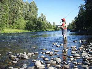
Foster Reservoir on the South Santiam River has boat ramps and a year-round marina while Green Peter Reservoir provides two improved boat ramps.[31][32] The South Santiam River offers salmon and steelhead fishing while Quartzville Creek is recognized for Class 4 and Class 5 kayaking and gold panning opportunities.[33]
Nearby hiking trails include Horse Rock Ridge, Soda Creek Falls Trail at Cascadia State Park and numerous trails throughout the Willamette National Forest. The Menagerie Wilderness provides rock climbing challenges.
An 18-hole golf course, Mallard Creek Golf Club, is 11 miles (18 km) northwest of Sweet Home. The nearest ski resort, Hoo Doo Ski Bowl, is 52 miles (84 km) to the east, near Santiam Pass.
Sweet Home has also been featured on the Travel Channel program "Cash and Treasures" for an abundant petrified wood find at Holleywood Ranch between Sweet Home and Holley, Oregon.[34]
Transportation
Sweet Home receives public transportation service from Linn Shuttle.
Education
Sweet Home is served by the Sweet Home School District. The district includes Sweet Home High School, a junior high school and four elementary schools. The district covers Sweet Home, Cascadia, Crawfordsville, Holley, Liberty, Pleasant Valley and other surrounding communities.[35]
Linn–Benton Community College operates a branch campus in Sweet Home.[36]
Media
The New Era newspaper is published weekly. The daily Albany Democrat-Herald also serves the city.[37][38]
Notable people
- Howard Bergerson, writer[39]
- Matt Slauson, offensive lineman, San Diego Chargers[40][41]
References
- ↑ "Jim Gourley". Democratic Party of Oregon. Retrieved 2 October 2015.
- 1 2 "US Gazetteer files 2010". United States Census Bureau. Archived from the original on 2012-07-14. Retrieved 2012-12-21.
- 1 2 "American FactFinder". United States Census Bureau. Retrieved 2012-12-21.
- ↑ "Population Estimates". United States Census Bureau. Archived from the original on 2013-06-17. Retrieved 2013-06-02.
- ↑ "American FactFinder". United States Census Bureau. Archived from the original on 2013-09-11. Retrieved 2008-01-31.
- ↑ "US Board on Geographic Names". United States Geological Survey. 2007-10-25. Retrieved 2008-01-31.
- 1 2 "Sweet Home (city) QuickFacts from the US Census Bureau". Quickfacts.census.gov. Retrieved 2012-03-12.
- ↑ "Police Chief: City of Sweet Home, Oregon" (PDF). City of Sweet Home. p. 2. Retrieved 2013-04-21.
- ↑ "City of Sweet Home - History". Sweet-home.or.us. Retrieved 2012-03-12.
- ↑ "Santiam Wagon Road". Retrieved 2012-03-20.
- ↑ "Santiam Wagon Road, 1865-1939". Oregon Historic Trails Fund. Retrieved 2013-04-21.
- ↑ "History of The Willamette National Forest (Chapter 5)". Foresthistory.org. Retrieved 2012-03-12.
- ↑ "Historical Look at Oregon's Wood Products Industry". State of Oregon. January 23, 2012. Retrieved February 28, 2014.
- ↑ Stein, Mark A. (1989-07-14). "Industry Fears Environmentalists : Loggers See Spotted Owl as a Harbinger of Doom". Los Angeles Times. Retrieved 2012-03-12.
- 1 2 "About the Oregon Jamboree". Oregon Jamboree. Retrieved 2013-04-21.
- ↑ "Sweet Home, OR". Google Maps. Retrieved 2013-04-21.
- ↑ "South Santiam River". Geographic Names Information System. United States Geological Survey. 1980-11-28. Retrieved 2013-04-21.
- ↑ Gregory, Irene (April 1968). "The Fossil Woods near Holley in the Sweet Home Petrified Forest, Linn County, Oregon" (PDF). The Ore Bin. State of Oregon Department of Geology and Mineral Industries. 30 (4): 57–76. Retrieved 2013-04-21.
- ↑ Climate Summary for Sweet Home, Oregon
- ↑ "Annual Estimates of the Resident Population for Incorporated Places: April 1, 2010 to July 1, 2015". Retrieved July 2, 2016.
- ↑ "Census of Population and Housing". Census.gov. Archived from the original on May 11, 2015. Retrieved June 4, 2015.
- ↑ "White's Metal Detectors". Whiteselectronics.com. Retrieved 2012-03-12.
- ↑ "Welcome to HEVI-ShotÂŽ". Hevishot.com. Retrieved 2012-03-12.
- ↑ "Cascade Timber Consulting, Inc". Cascadetimber.com. Retrieved 2012-03-12.
- ↑ Lair, Patrick (2005-09-28). "Weddle Bridge closes". Albany Democrat-Herald. Albany, Oregon. Retrieved 2013-04-21.
- ↑ Klindt, Robert S. (1989-12-03). "Oregon's bridges uncover simpler times". San Jose Mercury News. San Jose, California. Retrieved 2013-04-21.
- ↑ "South Fork Santiam River (Short) Covered Bridge" (PDF). Oregon Department of Transportation. Retrieved 2013-04-21.
- ↑ "City of Sweet Home Park System". Retrieved 2012-03-20.
- ↑ "Welcome to Sweet Home". Oregon Jamboree. Retrieved 2013-04-21.
- ↑ Waibel, Mona Hyer. "Quartzville Gold". OregonPioneers.com. Retrieved 2013-04-21.
- ↑ "Boat Escape to Foster Lake". BoatEscape.com. Retrieved 2013-04-21.
- ↑ "Green Peter Lake and Foster Lake, Oregon" (PDF). U.S. Army Corps of Engineers. 2009. Retrieved 2013-04-21.
- ↑ Yuskavitch, Jim (2008). Fishing Oregon: An Angler's Guide to Top Fishing Spots (2nd ed.). Guilford, Connecticut: Lyons Press. p. 120. ISBN 978-0-7627-4145-8. OCLC 213838754.
- ↑ Ast, Ellen (2007-12-27). "Rockin' in the tree world". Albany Democrat-Herald. Albany, Oregon. Retrieved 2012-03-20.
- ↑ "Our District". Sweethome.k12.or.us. Retrieved 2012-03-12.
- ↑ "LBCC: Sweet Home Center". Linnbenton.edu. 2012-01-02. Archived from the original on 2012-02-24. Retrieved 2012-03-12.
- ↑ The New Era
- ↑ "Albany Democrat-Herald". Albany Democrat-Herald. Retrieved 2013-04-21.
- ↑ Eckler, Jr., A. Ross (May 2010). "Howard Bergerson". Word Ways: The Journal of Recreational Linguistics. 43 (2): 82–88.
- ↑ Gehrett, Les (2011-07-29). "Former Sweet Home player goes back to work for Jets". Albany Democrat-Herald. Retrieved 2012-03-12.
- ↑ Gehlken, Michael (2016-05-07). "Chargers secure veteran C Matt Slauson". The San Diego Union Tribune. Retrieved 2016-06-06.
External links
 Media related to Sweet Home, Oregon at Wikimedia Commons
- Entry for Sweet Home in the Oregon Blue Book
Municipalities and communities of Linn County, Oregon, United States | ||
|---|---|---|
| Cities | 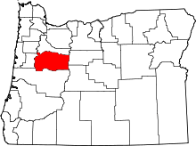 | |
| CDPs | ||
| Other unincorporated communities | ||
| Ghost towns | ||
| Footnotes | ‡This populated place also has portions in an adjacent county or counties | |