Bang Mun Nak District
| Bang Mun Nak บางมูลนาก | |
|---|---|
| Amphoe | |
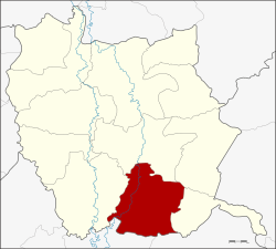 Amphoe location in Phichit Province | |
| Coordinates: 16°1′40″N 100°22′44″E / 16.02778°N 100.37889°ECoordinates: 16°1′40″N 100°22′44″E / 16.02778°N 100.37889°E | |
| Country |
|
| Province | Phichit |
| Area | |
| • Total | 377.7 km2 (145.8 sq mi) |
| Population (2005) | |
| • Total | 49,302 |
| • Density | 130.5/km2 (338/sq mi) |
| Time zone | ICT (UTC+7) |
| Postal code | 66120 |
| Geocode | 6605 |
Bang Mun Nak (Thai: บางมูลนาก) is a district (amphoe) in the southern part of Phichit Province, northern Thailand.
Geography
Neighboring districts are (from the west clockwise) Pho Thale, Taphan Hin, Thap Khlo, Dong Charoen of Phichit Province, Nong Bua and Chum Saeng of Nakhon Sawan Province.
Administration
The district is divided into 10 sub-districts (tambon), which are further subdivided into 78 villages (muban). Bang Mun Nak is a town (thesaban mueang) which covers the whole tambon, Bang Mun Nak. There are two townships (thesaban tambon) - Bang Phai and Wang Taku each cover parts of the same-named tambons. There are a further nine tambon administrative organizations (TAO).
| No. | Name | Thai name | Villages | Pop. | |
|---|---|---|---|---|---|
| 1. | Bang Mun Nak | บางมูลนาก | - | 9,240 | |
| 2. | Bang Phai | บางไผ่ | 12 | 7,677 | |
| 3. | Ho Krai | หอไกร | 9 | 6,283 | |
| 4. | Noen Makok | เนินมะกอก | 12 | 7,420 | |
| 5. | Wang Samrong | วังสำโรง | 7 | 3,825 | |
| 6. | Phum | ภูมิ | 5 | 2,380 | |
| 7. | Wang Krot | วังกรด | 6 | 2,592 | |
| 8. | Huai Khen | ห้วยเขน | 5 | 1,729 | |
| 9. | Wang Taku | วังตะกู | 12 | 5,509 | |
| 10. | Lam Prada | ลำประดา | 10 | 2,647 |
Missing numbers are tambon which now form Dong Charoen district.
References
External links
- amphoe.com (Thai)
This article is issued from Wikipedia - version of the 4/4/2016. The text is available under the Creative Commons Attribution/Share Alike but additional terms may apply for the media files.