Mae Lao District
| Mae Lao แม่ลาว | |
|---|---|
| Amphoe | |
|
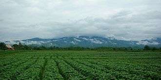
Field in Chom Mok Kaeo, Mae Lao District, with the Khun Tan Range in the background | |
 Amphoe location in Chiang Rai Province | |
| Coordinates: 19°47′24″N 99°41′59″E / 19.79000°N 99.69972°ECoordinates: 19°47′24″N 99°41′59″E / 19.79000°N 99.69972°E | |
| Country |
|
| Province | Chiang Rai |
| Seat | Pa Ko Dam |
| Area | |
| • Total | 406.0 km2 (156.8 sq mi) |
| Population (2005) | |
| • Total | 30,779 |
| • Density | 75.8/km2 (196/sq mi) |
| Time zone | ICT (UTC+7) |
| Postal code | 57250 |
| Geocode | 5716 |
Mae Lao (Thai: แม่ลาว; IPA: [mɛ̂ː lāːw]) is a district (amphoe) in the central part of Chiang Rai Province, northern Thailand.
History
The area of Mae Lao district was separated from Mueang Chiang Rai district and established a minor district (king amphoe) on 31 May 1993. It originally consisted of the four tambon Dong Mada, Chom Mok Kaeo, Bua Sali, and Pa Ko Dam.[1] It was upgraded to a full district on 5 December 1996.[2]
Geography
Neighboring districts are (from the west clockwise) Mae Suai, Mueang Chiang Rai and Phan of Chiang Rai Province.
The mountains of the Phi Pan Nam Range dominate the landscape of the district, which is named after the Lao River that flows through it
Administration
The district is divided into five sub-districts (tambon), which are further subdivided into 63 villages (muban). There are two townships (thesaban tambon). Mae Lao covers parts of tambon Dong Mada, and Pa Ko Dam parts of tambon Pa Ko Dam and Chom Mok Kaeo. There are a further five tambon administrative organizations (TAO).
| No. | Name | Thai name | Villages | Pop. | |
|---|---|---|---|---|---|
| 1. | Dong Mada | ดงมะดะ | 18 | 9,642 | |
| 2. | Chom Mok Kaeo | จอมหมอกแก้ว | 11 | 6,165 | |
| 3. | Bua Sali | บัวสลี | 12 | 4,389 | |
| 4. | Pa Ko Dam | ป่าก่อดำ | 13 | 6,227 | |
| 5. | Pong Phrae | โป่งแพร่ | 9 | 4,356 |
References
- ↑ ประกาศกระทรวงมหาดไทย เรื่อง แบ่งเขตท้องที่อำเภอเมืองเชียงราย จังหวัดเชียงราย ตั้งเป็นกิ่งอำเภอแม่ลาว (PDF). Royal Gazette (in Thai). 110 (74 ง): 19. June 8, 1993.
- ↑ พระราชกฤษฎีกาตั้งอำเภอเหนือคลอง อำเภอนายายอาม อำเภอท่าตะเกียบ อำเภอขุนตาล อำเภอแม่ฟ้าหลวง อำเภอแม่ลาว อำเภอรัษฎา อำเภอพุทธมณฑล อำเภอวังน้ำเขียว อำเภอเจาะไอร้อง อำเภอชำนิ อำเภอโนนดินแดง อำเภอปางมะผ้า อำเภอสนธิ อำเภอหนองม่วง อำเภอเบญจลักษ์ อำเภอโพนนาแก้ว อำเภอบุ่งคล้า อำเภอดอนมดแดง และอำเภอลืออำนาจ พ.ศ. ๒๕๓๙ (PDF). Royal Gazette (in Thai). 113 (62 ก): 5–8. November 20, 1996.
External links
 Chiang Rai Province travel guide from Wikivoyage
- amphoe.com
Chiang Rai | ||
|---|---|---|
| Main article |  | |
| Capital city | ||
| Districts (amphoe) | ||
| Related topics | ||