Wang Nuea District
| Wang Nuea วังเหนือ | |
|---|---|
| Amphoe | |
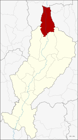 Amphoe location in Lampang Province | |
| Coordinates: 19°8′42″N 99°37′12″E / 19.14500°N 99.62000°ECoordinates: 19°8′42″N 99°37′12″E / 19.14500°N 99.62000°E | |
| Country |
|
| Province | Lampang |
| Seat | Wang Nuea |
| Amphoe established | 1938 |
| Area | |
| • Total | 1,034.3 km2 (399.3 sq mi) |
| Population (2008) | |
| • Total | 44,777 |
| • Density | 43.4/km2 (112/sq mi) |
| Time zone | THA (UTC+7) |
| Postal code | 52140 |
| Geocode | 5207 |
Wang Nuea (Thai: วังเหนือ; IPA: [wāŋ nɯ̌a]) is the northernmost district (amphoe) of Lampang Province, northern Thailand.
Geography

Neighboring districts are (from the east clockwise) Mae Chai and Mueang Phayao of Phayao Province, Ngao, Chae Hom and Mueang Pan of Lampang Province, Wiang Pa Pao and Phan of Chiang Rai Province.
Mountains dominate the landscape of the district, the Khun Tan Range on the western side and the Phi Pan Nam Range on the eastern.
History
Till 1904 the district Chae Hom was named Wang Nuea.[1] A new minor district (King Amphoe) Wang Nuea was established on May 15, 1938 as a subordinate of Chae Hom district.[2] It was upgraded to a full district in 1958.[3]
Administration
The district is subdivided into 8 subdistricts (tambon), which are further subdivided into 77 villages (muban). Wang Nuea and Ban Mai are the two townships (thesaban tambon), both covering parts of the tambon Wang Nuea. There are further 8 Tambon administrative organizations (TAO).
| No. | Name | Thai | Villages | Inh.[4] |
|---|---|---|---|---|
| 1. | Thung Hua | ทุ่งฮั้ว | 12 | 5,731 |
| 2. | Wang Nuea | วังเหนือ | 9 | 7,253 |
| 3. | Wang Tai | วังใต้ | 7 | 3,438 |
| 4. | Rong Kho | ร่องเคาะ | 16 | 10,346 |
| 5. | Wang Thong | วังทอง | 8 | 5,245 |
| 6. | Wang Sai | วังซ้าย | 10 | 5,049 |
| 7. | Wang Kaeo | วังแก้ว | 7 | 3,486 |
| 8. | Wang Sai Kham | วังทรายคำ | 8 | 4,229 |
References
- ↑ แจ้งความกระทรวงมหาดไทย เรื่อง เปลี่ยนชื่อแขวงในนครเชียงใหม่ นครลำปาง (PDF). Royal Gazette (in Thai). 21 (23): 381. 1904-09-04.
- ↑ ประกาศกระทรวงมหาดไทย เรื่อง ตั้งกิ่งอำเภอวังเหนือ (PDF). Royal Gazette (in Thai). 54 (0 ง): 3191–3192. 1938-03-21.
- ↑ พระราชกฤษฎีกาจัดตั้งอำเภอกระสัง อำเภอกระนวน อำเภอบางกอกใหญ่ อำเภอขุนหาร อำเภอพนา อำเภอปากช่อง อำเภอวังเหนือ อำเภอวังชิ้น อำเภอแม่ทา อำเภอหนองหมู อำเภอสระแก้ว อำเภออมก๋อย อำเภอบางซ้าย อำเภอทับสะแก อำเภอบุณฑริก อำเภอลานสะกา อำเภอจอมบึง อำเภอท่ายาง อำเภอสามเงา อำเภอฟากท่า อำเภอบ้านเขว้า อำเภอชานุมาน อำเภอแม่พริก อำเภอท่าสองยาง อำเภอสะเมิง อำเภอหนองแขม อำเภอพระแสง พ.ศ. ๒๕๐๑ (PDF). Royal Gazette (in Thai). 75 (55 ก): 321–327. 1958-07-22.
- ↑ "Population statistics 2008". Department of Provincial Administration.
External links
- amphoe.com (Thai)