Ananthagiri Hills
| Ananthagiri Hills | |
|---|---|
|
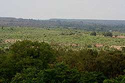
View from Ananthagiri Hills | |
| Highest point | |
| Coordinates | 17°18′43″N 77°51′47″E / 17.312°N 77.863°ECoordinates: 17°18′43″N 77°51′47″E / 17.312°N 77.863°E |
| Geography | |
| Location | Telangana, South India |
| Climbing | |
| Easiest route | Hyderabad |

Ananthagiri Hills are hills located at [1] Vikarabad, Ranga Reddy district, TG, India.[2][3][4] The water flows from these hills to Osmansagar and Himayathsagar.
It is one of the dense forests in Telangana Ananthagiri Temple is located in this forested area. It is the Birthplace of Musi river, which flows through Hyderabad. It is 5 km from Vikarabad

It is one of the earlist habitat areas. Ancient caves, medieval fort structures and temple shows the antiquity of this area.
Musi River
Main article: Musi River also known as Muchukunda River used to originate in Anantagiri Hills 90 kilometers to the west of Hyderabad and flowed due east for almost all of its course. It joins the Krishna River at Vadapally in Nalgonda district after covering a total distance of about 240 km.[5]
Tourist attractions near Ananthagiri Hills
Anantha Padmanabha Swamy Temple[6]
This temple is located in Ananthagiri hills, about 75 kilometers from Hyderabad built by Nizam nawabs , Lord Vishnu is in the form of Sri Anantha Padmanabha Swamy and Ananthagiri is named after him.
References
- ↑ "Ananthagiri Hills Resort". Retrieved 24 May 2015.
- ↑ http://www.hindu.com/2006/09/05/stories/2006090502460200.htm
- ↑ http://www.hindu.com/2006/09/08/stories/2006090822800500.htm
- ↑ http://www.hindu.com/2010/11/19/stories/2010111963950300.htm
- ↑ Tourism destinations in AP. "Ananthagiri Hills". Retrieved 19 October 2012.
- ↑ "AnanthaPadmanabha swamy temple".