Węgorzewo
| Węgorzewo | ||
|---|---|---|
|
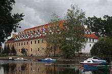
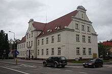
Post-war buildings in Węgorzewo Town Centre. Much of the town was destroyed by Soviet shelling during World War II, when it was part of Germany as Angerburg. | ||
| ||
 Węgorzewo | ||
| Coordinates: 54°13′N 21°45′E / 54.217°N 21.750°E | ||
| Country |
| |
| Voivodeship | Warmian-Masurian | |
| County | Węgorzewo County | |
| Gmina | Gmina Węgorzewo | |
| Established | 15th century | |
| Town rights | 1571 | |
| Government | ||
| • Mayor | Krzysztof Piwowarczyk | |
| Area | ||
| • Total | 10.87 km2 (4.20 sq mi) | |
| Population (2006) | ||
| • Total | 11,638 | |
| • Density | 1,100/km2 (2,800/sq mi) | |
| Time zone | CET (UTC+1) | |
| • Summer (DST) | CEST (UTC+2) | |
| Postal code | 11-600, 11-601 | |
| Area code(s) | +48 87 | |
| Car plates | NWE | |
| Website | http://www.wegorzewo.pl | |

Węgorzewo [vɛŋɡɔˈʐɛvɔ] (German: Angerburg, Lithuanian: Ungura) is a tourist town in the Warmian-Masurian Voivodeship, Poland, not far from the border with Russia's Kaliningrad Oblast. It is the seat of Węgorzewo County. Lake Mamry (called Mauersee until 1945) is close to the town.
Etymology
The town's names in different languages are derived from local names for European eels, which used to live in the area in great numbers. The German name Angerburg (![]() listen ) is derived from the Old Prussian word for eel, Anger, which the German Teutonic Knights appropriated after conquering the Old Prussians. The Polish name Węgorzewo (and the older Węgobork) is derived from Węgorz, while the local Lithuanian names Ungura and Unguris comes from Ungurys. A Lithuanian variation is Angerburgas.
listen ) is derived from the Old Prussian word for eel, Anger, which the German Teutonic Knights appropriated after conquering the Old Prussians. The Polish name Węgorzewo (and the older Węgobork) is derived from Węgorz, while the local Lithuanian names Ungura and Unguris comes from Ungurys. A Lithuanian variation is Angerburgas.
History
Foundation
The town was first mentioned in a 1335 chronicle as Angirburg, or "eel castle", a settlement of the Teutonic Knights with a block house, a palisade, and a watchtower. A 1341 document reported that the Teutonic Order had bestowed land on the river Angerapp (Angrapa) upon twelve Old Prussians for their loyal service. The Grand Duke of Lithuania, Kęstutis, destroyed the castle in 1365, although the order rebuilt the castle out of stone thirty years later. The completion of the stone castle Angerburg allowed the Teutonic Knights to increase development of the surrounding countryside.

The land around the Angerburg castle began to be settled by the end of the 15th century. As it was primarily farmland, the Mauersee (Lake Mamry) was blocked up to allow the construction of a watermill. Ca. 1510 a locality known as Neudorf ("new village") or Gerothwol had developed near the Angerburg. After the foundation of the Duchy of Prussia in 1525, the Angerburg became the seat of a district head. Albert, Duke of Prussia, granted the settlement town privileges and determined that it should be called Angerburg like the nearby castle. A large part of the town was destroyed by a fire in 1608, including a wooden church and the 20-year-old town hall.
Being situated in the ethnographic region known as Lithuania Minor, Angerburg had a German majority with sizable minorities of Masurians and Lietuvninks. The Lietuvnink minority diminished after the 16th and 17th centuries. The town suffered from the Swedish-Polish Wars, attacks by Polish Tatars, and plague epidemics, the last outbreak of which occurred in 1710 and claimed 1,111 victims.[1]
Kingdom of Prussia
Angerburg, like much of Little Lithuania became part of the Kingdom of Prussia in 1701 and was named a garrison town of the Prussian Army in 1718. A harbor was built on the Angerapp, allowing an aqueduct to be built in 1740 as well as an expansion of the garrison to include ten barracks. Angerburg had approximately 1,800 inhabitants at this time. Its inhabitants suffered from warfare, however, as Angerburg was occupied by Russian troops during the Seven Years' War. During the Napoleonic Wars, typhus was brought by Russian troops and the town was plundered by French and Polish troops.
Angerburg was included in the Prussian province of East Prussia in 1773 and became the district seat of Landkreis Angerburg in 1818. The town became part of the German Empire upon the Prussian-led unification of Germany in 1871. A teaching seminary and a deaf-mute school were opened in 1820, and the town's population increased to over 3,500. The canalization of the Angerapp and the expansion of the harbor in 1856 allowed business to expand, and the garrison left the town in 1858. The district court and the office of the public prosecutor moved from Angerburg to Lyck after the Kreistag, or district parliament, hindered the connection of the town to developing road network and railways. Angerburg was first connected to the railroad network in 1898, allowing it to develop into a trade center. The town became especially known for its Behindertenanstalt Bethesda, an institute for those with mental retardation.
World Wars

Angerburg became a garrison town again after the outbreak of World War I (1914–18), when it had a population of 5,800 inhabitants. The German-Russian military cemetery Jägerhöhe was located nearby. The war did not impact the town greatly, and Angerburg grew through new housing developments afterwards. Angerburg also began to develop through tourism after the opening of the Angerapp to regular navigation. At the beginning of the Third Reich, the town had a population of 7,700 which profited from a local cavalry regiment. Through incorporation of neighboring communities, Angerburg expanded to include 10,922 inhabitants in 1939.
Like the rest of East Prussia, Angerburg was initially only indirectly affected by World War II (1939–45), such as casualties of war and supply shortages. This situation changed as the eastern front grew near during the winter of 1944-45. Unlike the neighboring town of Goldap to the east, Angerburg was not involved in fighting, but was given up by the Wehrmacht as the Soviet Red Army advanced. After the Red Army reached Elbing and cut off East Prussia from the rest of Germany, the citizens of Angerburg were forced to evacuate the province by traveling across the Vistula Lagoon or to Pillau. The Red Army reached Angerburg on January 25, 1945 and destroyed much of the town; only a few buildings remained of the old town center.
Poland
According to the post-war Potsdam Conference, Angerburg was placed under Polish administration and renamed Węgorzewo. The remaining German-speaking population was expelled westward and replaced with Poles who either came from central Poland or were themselves expelled from the Polish Eastern Borderlands (Kresy), especially Wilno and Grodno. Some Lemko also came from the Beskids.
Węgorzewo initially suffered economically after the fall of the Iron Curtain and the Revolutions of 1989, but has become a popular tourist site in the Masurian Lake District. The town is famous for the music festivals which take place in summertime, including a rock festival, a sailors' song festival, and a poetic song festival.
Notable residents
- Georg Andreas Helwing (1666–1748), botanist
- Siegfried Heinrich Aronhold (1819–1884), mathematician
- Gustav Dodilett (1820–1894), parliamentarian
- Ferdinand Leopold Krieger (1823–1885), representative
- Rodolphe Radau (1835–1911), astronomer
- Gustav Bolle (1842–1902), dramatist
- Kurt Haehling (1893–1983), Wehrmacht general
- Herbert Jankuhn (1905–1990), archaeologist
- Klaus Ewerth (1907–1943), Kriegsmarine officer
- Andreas Hillgruber (1925–1989), historian
International relations
Twin towns — Sister cities
Węgorzewo is twinned with:
|
References
External links
- Municipal website
- Angerburg - Ostpreußen, town and district history (German)
- Węgorzewo rock music festival (Polish)
Coordinates: 54°13′N 21°45′E / 54.217°N 21.750°E