Elbląg
| Elbląg | |||
|---|---|---|---|
|
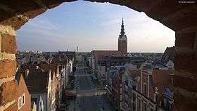
Old Town in Elbląg | |||
| |||
 Elbląg | |||
| Coordinates: 54°10′0″N 19°24′0″E / 54.16667°N 19.40000°E | |||
| Country |
| ||
| Voivodeship | Warmian-Masurian | ||
| County | City county | ||
| Established | 1237 | ||
| City rights | 1246 | ||
| Government | |||
| • Mayor | Witold Wróblewski | ||
| Area | |||
| • Total | 79,82 km2 (3,082 sq mi) | ||
| Population (December 31, 2011) | |||
| • Total | 124 257[1] | ||
| Time zone | CET (UTC+1) | ||
| • Summer (DST) | CEST (UTC+2) | ||
| Postal code | 82-300 to 82-315 | ||
| Area code(s) | +48 55 | ||
| Car plates | NE | ||
| Climate | Dfb | ||
| Website | http://www.elblag.eu | ||
Elbląg [ˈɛlblɔŋk] (German: Elbing) is a city in northern Poland on the eastern edge of the Żuławy region with 124,257 inhabitants (December 31, 2011). It is the capital of Elbląg County and has been assigned (since 1999) to the Warmian-Masurian Voivodeship. Previously it was the capital of Elbląg Voivodeship (1975–1998) and a county seat within Gdańsk Voivodeship (1945–1975).
Geographical location
Elbląg is located about 55 kilometres (34 miles) south-east of Gdańsk and 90 km (56 mi) south-west of Kaliningrad. The city is a port on the river Elbląg, which flows into the Vistula Lagoon about 10 km (6 mi) to the north, thus giving the city access to the Baltic Sea via the Russian-controlled Strait of Baltiysk. The Old Town (Polish: Stare Miasto) is located on the river Elbląg connecting Lake Drużno to the Vistula Lagoon, about 10 km (6 mi) from the lagoon and 60 km (37 mi) from Gdańsk.
Modern city
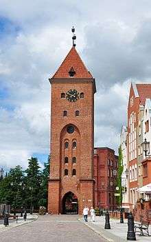

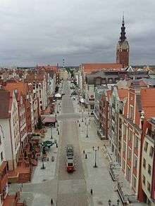
The German Elbing was almost totally destroyed at the end of World War II. The city became the Polish Elbląg after the war, when the area was ceded to Poland under border changes promulgated at the Potsdam Conference. Parts of the inner city were gradually rebuilt, and around 2000 rebuilding was begun in a style emulating the previous architecture, in many cases over the same foundations and utilizing old bricks and portions of the same walls. The western bank part of the old city is now completely gone.
The modern city adjoins about half the length of the river between Lake Drużno and Elbląg Bay (Zatoka Elbląska, an arm of the Vistula Lagoon), and spreads out on both banks, though mainly on the eastern side. To the east is the Elbląg Upland (Wysoczyzna Elbląska), a dome pushed up by glacial compression, 390 km2 in diameter and 200 m (656.17 ft) high at its greatest elevation.[2] It gives the appearance of ridges and parkland.
Views to the west show flat fields extending to the horizon; this part of the Vistula Delta (Żuławy Wiślane) is used mainly for agricultural purposes. To the south are the marshes and swamps of Drużno. The Elbląg River has been left in a more natural state through the city, but elsewhere it is a controlled channel with branches. One of them, the Jagielonski Channel (Kanał Jagieloński), leads to the Nogat River, along which navigation to Gdańsk is common. The Elbląg Canal (Kanał Elbląski) connecting Lake Drużno with Drwęca River and Lake Jeziorak is a popular tourist site.
Elbląg is not a deep-water port. The draft of vessels using its waterways must be no greater than 1.5 m (4 ft 11.06 in) by law. The turning area at Elbląg is 120 m (393.70 ft) diameter and a pilot is required for large vessels.[3] Deep water vessels cannot manoeuvre; in that sense, Elbląg has become a subsidiary port of Gdańsk. Traffic of smaller vessels at Elbląg is within the river and very marginal, while larger vessels cannot reach the open Baltic Sea because the channel, once built in East-Prussia to go through the peninsula, has belonged to Russia since 1945. The river has become almost stagnant and its banks are overgrown with waterlilies and tulies. The city features three quay complexes, movable cranes, and railways. One of its specialities is heavy machinery.
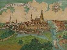
- Ancient and recent views of Elbląg

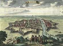 Elbing in 1720 atlas by Pieter van der Aa, based on earlier print by Matthäus Merian (left picture)
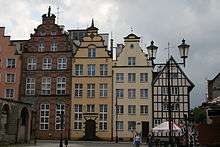
 Reconstructed buildings in the Old City
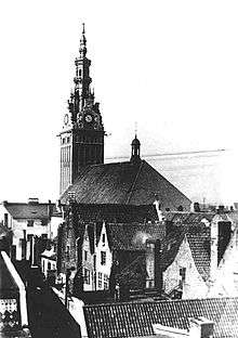
 St. Nicholas Church
Names
Etymology
Elbląg is the Polish derivative of the German name Elbing, which was assigned by the Teutonic Knights to the citadel and subsequent town placed by them in 1237 next to the river. The purpose of the citadel was to prevent the Old Prussian settlement of Truso from being reoccupied, as the German crusaders were at exterminatory war with the pagan Prussians. The citadel was named after the river, itself of uncertain etymology. One traditional etymology connects it to the name of the Helveconae, a Germanic tribe mentioned in Ancient Greek and Latin sources, but the etymology or language of the tribal name is not known.
Historical names
Early sources: river Ilfing (890), Castrum de Elbingo quod a nomine fluminis Elbingum appellavit (1237 — Peter of Dusburg, Chronicon terrae Prussiae), in Elbingo (1239), in Elbing (1242), in Elbinge ... fluvium Elbinc (1246, city charter), de Elbingo (1250), in Elbyngo (1258), vitra Elbingum (1263), Elvingo (1293), in Elbingo (1300), in Elvingo (1389), czum Elbinge (1392), czu Elbing (1403), Elwing (1410), czum Elwinge (1412), Elbing (1414–1438), Elbyang (before 1454), Elbing (1508), ku Elbiągowi (1634), w Elblągu (1661), w Elblągu (1661).[4][5]
History
Old Prussian Truso
![]() Teutonic Order 1246–1466
Teutonic Order 1246–1466
![]() Kingdom of Poland 1466–1569
Kingdom of Poland 1466–1569
![]() Polish–Lithuanian Commonwealth 1569–1772
Polish–Lithuanian Commonwealth 1569–1772
![]() Kingdom of Prussia 1772–1871
Kingdom of Prussia 1772–1871
![]() German Empire 1871–1918
German Empire 1871–1918
![]() Weimar Germany 1918–1933
Weimar Germany 1918–1933
![]() Nazi Germany 1933–1945
Nazi Germany 1933–1945
![]() People's Republic of Poland 1945–1989
People's Republic of Poland 1945–1989
![]() Republic of Poland 1989–present
Republic of Poland 1989–present
The settlement was first mentioned as "Ilfing" in The Voyages of Ohthere and Wulfstan, an Anglo-Saxon chronicle written in King Alfred's reign using information from a Viking who had visited the area.
During the Middle Ages, the Old Prussian settlement of Truso was located on Lake Drużno, near the current site of Elbląg in historical Pogesania; the settlement burned down in the 10th century.[6] Early in the 13th century the Teutonic Knights conquered the region, built a castle, and founded Elbing on the lake, with a population mostly from Lübeck (today the lake, now much smaller, no longer reaches the city). After the defeat of the Teutonic Knights and the destruction of the castle by the inhabitants, the city successively came under the sovereignty of the Polish crown (1466), the Kingdom of Prussia (1772), and Germany (1871). Elbing was heavily damaged in World War II, and its German citizens were expelled upon the war's end. The city became part of Poland in 1945 and was repopulated with Polish citizens.
The seaport of Truso was first mentioned ca. 890 by Wulfstan of Hedeby, an Anglo-Saxon sailor, travelling on the south coast of the Baltic Sea at the behest of King Alfred the Great of England. The exact location of Truso was not known for a long time, as the seashore has significantly changed, but most historians trace the settlement inside or near to modern Elbląg on Lake Drużno. Truso was located at territory already known to the Roman Empire and earlier.
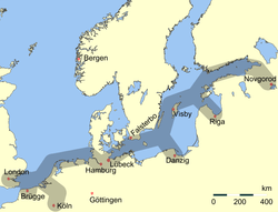
It was an important seaport serving the Vistula River bay on the early medieval Baltic Sea trade routes which led from Birka in the north to the island of Gotland and to Visby in the Baltic Sea. From there, traders continued further south to Carnuntum along the Amber Road. The ancient Amber Road led further southwest and southeast to the Black Sea and eventually to Asia. The east-west trade route went from Truso, along the Baltic Sea to Jutland, and from there inland by river to Hedeby, a large trading center in Jutland. The main goods of Truso were amber, furs, and slaves.
Archaeological finds in 1897 and diggings in the 1920s placed Truso at Gut Hansdorf. A large burial field was also found at Elbing. Recent Polish diggings have found burned beams and ashes and thousand-year-old artifacts in an area of about 20 hectares. Many of these artifacts are now displayed at the Elbing Museum.
Prussian Crusade
Attempts to conquer Prussian land began in 997, when Bolesław I Chrobry, at the urging of the Pope, sent a contingent of soldiers and a missionary (Adalbert of Prague) to the pagan Prussians, a non-Slavic people, on a crusade of conquest and conversion. The crusade encompassed much of the Baltic Sea coast, including Danzig (present day Gdańsk), and other areas of the coast up to Sambia. Starting in 1209 additional crusades were called for by Konrad of Masovia, who mainly sought to conquer Prussian territory, rather than actually convert the indigenous Prussians. Despite heroic efforts, Old Prussian sovereignty would eventually collapse after a succession of wars instigated by Pope Honorius III and his frequent calls for crusade.
Before the Prussians and their neighbors to the west, the Pomeranians, were finally brought to heel, Polish rulers and the Duchy of Masovia, both by then Christianised peoples, would be continually frustrated in their attempts at northern expansion. Aside from minor border raids, major campaigns against the Prussians would be launched in 1219, 1220, and 1222. After a particularly sound defeat by Prussian forces in 1223, Polish forces in Chełmno, the seat of Christian of Oliva and the Duchy of Masovia, were forced onto the defensive.
In 1226 Duke Konrad I of Masovia summoned the Teutonic Knights for assistance; by 1230 they had secured Chełmno (Culm) and begun claiming conquered territories for themselves under the authority of the Holy Roman Empire, although these claims were rejected by the Poles, whose ambition had been to conquer Prussia all along. The Teutonic Order's strategy was to move down the Vistula and secure the delta, establishing a barrier between the Prussians and Danzig. The victorious Teutonic Knights built a castle at Elbing, near, if not on top of, the destroyed Prussian town of Truso.
The Chronicon terrae Prussiae[7] describes the conflict in the vicinity of Lake Drusen (now Drużno) shortly before the founding of Elbing:
- ″Omnia propugnacula, que habebant in illo loco, qui dicitur (list) ... circa stagnum Drusine ... occisis et captiis infidelibus, potenter expugnavit, et in cinerem redigendo terre alteri coequavit."
- "All the little redoubts that they had in that place, which are said to be (list) ... and around the Drusine marsh ... he (frater Hermannus magister) assaulted and levelled by rendering them into ash, after the infidels had been killed or captured."
Truso did not disappear suddenly to be replaced with the citadel and town of Elbing during the Prussian Crusade. It had already burned down in the tenth century, with the population dispersed in the area.
Foundation of Elbing
The Chronicon terrae Prussiae[8] describes the founding of Elbing under the leadership of Hermann Balk. After building two ships, the Pilgerim (Pilgrim) and the Vridelant (Friedland), with the assistance of Margrave Henry III of Margraviate of Meissen, the Teutonic Knights used them to clear the Vistula Lagoon (Frisches Haff) and the Vistula Spit of Prussians:
- ... et recens mare purgatum fuit ab insultu infidelium ...
- ... "and the Vistula Spit was purged of the insult of the infidels..."
Apparently the river was in Pomesania, which the knights had just finished clearing, but the bay was in Pogesania. The first Elbing was placed in Pogesania:
- Magister ... venit ad terram Pogesanie, ad insulam illam ... que est in media fluminis Elbingi, in illo loco, ubi Elbingus intrat recens mare et erexit ibi castrum, quod a nomine fluminis Elbingum appellavit, anno dominice incarnacionis MCCXXXVII. Aliqui referunt, quod idem castrum postea ab infidelibus fuerit expugnatum, et tunc ad eum locum, ubi nunc situm est, translatum, et circa ipsum civitas collocata.[9]
- "The master ... came to the region of Pogesania, to that island which is in the middle of the Elbing river, in that place where the Elbing enters the Vistula Lagoon, and built there a fort, which he called by the name of the Elbing River, in the year of the incarnation of the Lord, 1237. Others report that the same fort was attacked by the infidels and then was moved to the place where it is now situated, and the city gathered around it."
Both landings were amphibious operations conducted from the ships. The Chronicon relates that they were in use for many years and then were sunk in Lake Drusen. In 1238 the Dominican Order was invited to build a monastery on a grant of land. Pomesania was not secured, however, and from 1240-1242 the order began building a brick castle on the south side of the settlement, where archaeologists now believe Truso had been. It may be significant that Elbing's first industry was the same as Truso's had been: manufacture of amber and bone artifacts for export. In 1243 William of Modena created the Diocese of Pomesania and three others. They were at first only ideological constructs, but the tides of time turned them into reality in that same century.
The foundation of Elbing was perhaps not the end of the Old Prussian story in the region. In 1825 a manuscript listing a vocabulary of the Baltic Old Prussian language, named the Elbing-Prussian Dictionary (German: Elbing-Preußisches Wörterbuch), or more commonly in English just Elbing Vocabulary, was found among some manuscripts from a merchant's house. It contained 802 words in a dialect now termed Pomesanian with their equivalents in an early form of German.
The origin of the vocabulary remains unknown. Its format is like that of modern travel dictionaries; i.e., it may have been used by German speakers to communicate with Old Prussians, but the specific circumstances are only speculative. The manuscript became the Codex Neumannianus. It disappeared after a British bombing raid destroyed the library at Elbing but before then facsimiles had been made. The date of the MSS was estimated at ca. 1400, but it was a copy. There is no evidence concerning the provenance of the original, except that it must have been in Pomesanian.
Hanseatic Elbing
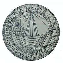
In 1246 the town was granted a constitution under Lübeck law, used in maritime circumstances, instead of Magdeburg rights common in other cities in Central Europe. This decision of the Order was in keeping with its general strategy of espousing the trade association that in 1358 would become the Hanseatic League. The Order seized on this association early and used it to establish bases throughout the Baltic. The Order's involvement in the League was somewhat contradictory. In whatever cities they founded the ultimate authority was the commander of the town, who kept office in the citadel, typically used as a prison. Lübeck law, on the other hand, provided for self-government of the town.
Membership in the Hanseatic League meant having important trading contacts with England, Flanders, France, and the Netherlands. The city received numerous merchant privileges from the rulers of England, Poland, Pomerania, and the Teutonic Order. For instance, the privilege of the Old Town (German: Altstadt, Polish: Stare Miasto) was upgraded in 1343, while in 1393 it was granted an emporium privilege for grains, metals, and forest products.
Except for the citadel and churches, Elbing at the time was more of a small village by modern standards. Its area was 300 m × 500 m (984.25 ft × 1,640.42 ft). It featured a wharf, a marketplace and five streets, as well as a number of churches. The castle was completed in 1251. In 1288 fire destroyed the entire settlement except for the churches, which were of brick. A new circuit wall was started immediately. From 1315 to 1340 Elbląg was rebuilt. A separate settlement called New Town (German: Neustadt) was founded ca. 1337 and received Lübeck rights in 1347. In 1349 the Black Death struck the town, toward the end of the European plague. After the population recovered it continued building up the city and in 1364 a crane was built for the port.
The German-language Elbinger Rechtsbuch,[10] written in Elbing, Prussia documented among other laws for the first time Polish common law. The German-language Polish laws are based on the Sachsenspiegel[11] and were written down to aid the judges. It is thus the oldest source for documented Polish common law and is in Polish referred to as the Księga Elbląska (Book of Elbląg[12]). It was written down in the second half of the 13th century.
Kingdom of Poland
In 1440 several western and eastern Prussian towns formed the Prussian Confederation, which led the revolt of Prussia against the rule of the Teutonic Knights in 1454. The burghers destroyed the Teutonic Order castle. For assistance against the Order, the Confederation asked for help from King Casimir IV of Poland; Casimir's subsequent claiming of Prussia led to the Thirteen Years' War.
After the Section of Prussians and Polish victory over the Teutonic Order, the city became part of the autonomous province of Royal Prussia under the suzerainty of the Polish crown in the Second Peace of Thorn. The city was known to the Polish crown by its Polish name Elbląg. With the creation of the Polish-Lithuanian Commonwealth in 1569, the city was brought under direct control of the Polish crown.
With the 16th century Protestant Reformation the burghers became Lutherans and the first Lutheran Gymnasium was established in Elbląg in 1535.
From 1579 Elbing/Elbląg had close trade relations with England, to which the city accorded free trade. English, Scottish, and Irish merchants settled in the city. They formed the Scottish Reformed Church of Elbląg and became Elbing citizens, aiding Lutheran Sweden in the Thirty Years' War. The rivalry of nearby Danzig interrupted trading links several times. By 1618 Elbląg had left the Hanseatic League owing to its close business dealings with England.
Famous inhabitants of the city at that time included native sons Hans von Bodeck and Samuel Hartlib. During the Thirty Years' War, Swedish Chancellor Axel Oxenstierna brought the Moravian Brethren refugee John Amos Comenius to Elbląg for six years (1642–48). In 1642 Johann Stobäus, who composed with Johann Eccard, published the Preussische Fest-Lieder, a number of evangelical Prussian songs. In 1646 the city recorder Daniel Barholz noted that the city council employed Bernsteindreher, or Paternostermacher, licensed and guilded amber craftsmen who worked on prayer beads, rosaries, and many other items made of amber. Members of the Barholz family became mayors and councillors.
During the Thirty Years' War, the Vistula Lagoon was the main southern Baltic base of King Gustavus Adolphus of Sweden, who was hailed as the protector of the Protestants. By 1660 the Vistula Lagoon had gone to Elector Frederick William of Brandenburg-Prussia, but was returned in 1700.
The poet Christian Wernicke was born in 1661 in Elbing, while Gottfried Achenwall became famous for his teachings in natural law and human rights law. In 1700-1710 it was occupied by Swedish troops. In 1709 it was besieged, taken by storm on February 2, 1710 by Russian troops with support of Prussian artillery. The city was handed over to Polish King Augustus II in 1712.
The Imperial cartographer Johann Friedrich Endersch completed a map of Warmia (German: Karte des Ermlandes) in 1755 and also made a copper etching of the galley named "The City of Elbląg" (German: Die Stadt Elbing) .
During the War of the Polish Succession in 1734, Elbing/Elbląg and Danzig were placed under military occupation by Russia and Saxony.[13] The town came again under occupation by Russia from 1758-1762 during the Seven Years' War.
Hohenzollern Prussia
During the First Partition of Poland in 1772, resulting in the re-unification of Prussia, the city state was annexed by King Frederick the Great of the Kingdom of Prussia. Elbing became part of the new Prussian Province of West Prussia in 1773. In the 1815 provincial reorganization following the Napoleonic Wars, Elbing and its hinterland were included within Regierungsbezirk Danzig in West Prussia.
Elbing industrialized under the sovereignty of the Hohenzollern kings in Berlin. In 1828 the first steamship was built by Ignatz Grunau. In 1837 Ferdinand Schichau started the Schichau-Werke company in Elbing as well as another shipyard in Danzig later on. Schichau constructed the Borussia, the first screw-vessel in Germany. Schichau-Werke built hydraulic machinery, ships, steam engines, and torpedoes. After the inauguration of the railway to Königsberg in 1853, Elbing's industry began to grow. Schichau worked together with his son-in-law Carl H. Zise, who continued the industrial complex after Schichau's death. Schichau erected large complexes for his many thousands of workers.
Georg Steenke, an engineer from Königsberg, connected Elbing near the Baltic Sea with the southern part of Prussia by building the Oberländischer Kanal (Elbląg Canal).
Elbing became part of the Prussian-led German Empire in 1871 during the unification of Germany. As Elbing became an industrial city, the Social Democratic Party of Germany (SPD) frequently received the majority of votes; in the 1912 Reichstag elections the SPD received 51% of the vote. After World War I, most of West Prussia became part of the Second Polish Republic. Elbing was joined to German East Prussia, and was separated from Weimar Germany by the Polish Corridor.
Mormons started filming the church records of Elbing's citizens in Kirchenbücher. Records dating from 1577 to 1890 are available.
Third Reich
During the Nazi German era (1933–1945), three subcamps of the Stutthof concentration camp were located near the town: Elbing, Elbing (Org. Todt), and Elbing (Schinau). These were closed and many of the German inhabitants of Elbing forced to flee as the Soviet Red Army approached the city toward the end of World War II (see Evacuation of East Prussia). Laid under siege since January 23, 1945, about 65% of the city infrastructure was destroyed, including most of the historical city center. The town was captured by the Soviet Red Army during the night of February 9/10, 1945. During the first days of the fighting most of the population of approximately 100,000 persons fled, except about 20,000. After the end of war, in spring 1945, the region together with the town of Elbing became part of Poland as a result of the Potsdam Conference.
Almost all Germans who remained or returned were expelled by the communist regime during the following months. The city was settled by the Polish expellees from the Soviet Union.
History after 1945
After the expulsion of most of the German population, the city was repopulated and given the Polish name Elbląg. Of the new inhabitants, 98% were Poles expelled from Polish areas annexed by the Soviet Union, or Polish peasants from central Poland. Parts of the damaged historical city center were completely demolished, with the bricks being used to rebuild Warsaw and Gdańsk. The Communist authorities had originally planned that the Old Town, utterly destroyed during the fighting since January 23, 1945, would be built over with blocks of flats; however, economic difficulties thwarted this effort. Two churches were reconstructed and the remaining ruins of the old town were torn down in the 1960s.
Along with Tricity and Szczecin, Elbląg was the scene of rioting in the coastal cities in 1970 (see also Polish 1970 protests). Since 1990 the German minority population has had a modest resurgence, with the Elbinger Deutsche Minderheit Organization counting around 450 members in 2000.
Restoration of the Old Town began after 1989. Since the beginning of the restoration, an extensive archaeological programme has been carried out. Most of the city's heritage was destroyed during the construction of basements in the 19th century or during World War II, but the backyards and latrines of the houses remained largely unchanged, and have provided information on the city's history. In some instances, private investors have incorporated parts of preserved stonework into new architecture. By 2006, approximately 75% of the Old Town had been reconstructed. The city museum presents many pieces of art and items of everyday use, including the only 15th century binoculars preserved in Europe.
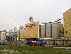
Elbląng is home to the Elbrewery, Poland's largest brewery, which belongs to the Żywiec Group.
Population
| Year | Number of inhabitants |
|---|---|
| 1772 | 11,952 |
| 1781 | 15,768 |
| 1826 | 22,115 |
| 1831 | 17,761 |
| 1875 | 33,520 |
| 1880 | 35,842 |
| 1885 | 38,278 |
| 1890 | 41,576 |
| 1900 | 52,518 |
| 1910 | 58,636 |
| 1925 | 67,878 |
| 1933 | 72,409 |
| 1939 | 83,190 |
| 1950 | approx. 48,000 |
| 1970 | approx. 90,000 |
| 2011 | 124,257 |
Note that the above table is based on primary, possibly biased, sources.[14][15][16][17][18]
Tourist attractions
Until World War II there were many Gothic, renaissance and baroque houses in Elbląg's Old Town; some of them are reconstructed. Other preserved buildings are:
- St. Nicholas Cathedral - a monumental 13th-century Gothic church (cathedral only from 1992, before it was a parochial church), damaged by fire in the late 18th century, then destroyed in World War II and reconstructed
- city gate (Brama Targowa) - erected in 1319
- St. Mary's Church - former Dominican church, erected in the 13th century, rebuilt in the 14th and 16th centuries; damaged in World War II and reconstructed in 1961 as an art gallery; remnants of cloister are partially preserved
- Holy Ghost church with hospital, from the 14th century
- Corpus Christi church from the 14th century
Institutions of higher education
- Elbląg Higher School of Arts and Economics (Polish: Elbląska Uczelnia Humanistyczno-Ekonomiczna)[19]
- Faculty of Pedagogy
- Faculty of Administration
- Faculty of Health Sciences
- Faculty of Economics and Politics
- Elbląg Higher State College of Vocational Education (Państwowa Wyższa Szkoła Zawodowa)[20]
- Faculty of Pedagogy and Foreign Languages
- Faculty of Economics
- Faculty of Applied Computer Science
- Faculty of Technical Sciences
- Bogdan Jański Higher School, Faculty in Elbląg (Szkoła Wyższa im. Bogdana Jańskiego)[21]
- Faculty of Management and Land Management
- Elbląg Diocese Theological Seminary (Wyższe Seminarium Duchowne Diecezji Elbląskiej)[22]
- Regent College - Foreign Language Teacher Training College (Regent College - Nauczycielskie Kolegium Języków Obcych)[23]
- Faculty of English Studies
Sports
- EB Start Elbląg - women's handball team playing in Polish Ekstraklasa Women's Handball League: 5th place in 2003/2004 season.
- Olimpia Elbląg - men's football club
Politics
Elbląg constituency
Members of Parliament (Sejm) elected from Elbląg constituency
- Jan Antochowski, SLD-UP
- Danuta Ciborowska, SLD-UP
- Witold Gintowt-Dziewałtowski, SLD-UP
- Stanisław Gorczyca, PO
- Jerzy Müller, SLD-UP
- Adam Ołdakowski, Samoobrona
- Andrzej Umiński, SLD-UP
- Stanisław Żelichowski, PSL
International relations
Twin towns - Sister cities
Elbląg is twinned with:[24][25]
|
|
Notable residents
- Georg Kleefeld (1522–1576), mayor of Danzig
- Hans von Bodeck (1582–1658), diplomat and Chancellor of Brandenburg
- John Amos Comenius (1592–1670), educator
- Samuel Hartlib (ca. 1600-1662), teacher and scientist
- Daniel Bärholz (1641–1688) Elbing councilman and Baroque poet
- Christian Wernicke (1661–1725), epigrammist and diplomat
- Johann Friedrich Endersch (1705–1769), mathematician geographer
- Gottfried Achenwall (1719–1772), statistician
- Frederick Henrich Weissenfels (1728–1806), soldier, American Revolution in New York
- Wilhelm Eduard Albrecht (1800–1876), lawyer, member of Göttinger Sieben
- Bruno Erhard Abegg (1803–1848), statesman of Königsberg
- Ferdinand Schichau (1814–1896), founder of the Schichau-Werke in Elbing and Danzig
- John Prince-Smith (1809–1874), liberal economist and politician in Germany
- Johannes Kohtz (1843–1918), German chess player
- Paul Pulewka (1896–1989) German pharmacologist
- Max Reimann (1898–1977), president of the Communist Party of Germany
- Erich Brost (1903–1995) publisher
- Günter Kuhnke (1912–1990), Admiral
- Hans-Dieter Lange (1926–2012), journalist
- Ursula Karusseit (born 1939), German actress
- Bernd Neumann (born 1942), Minister of Culture of Germany since 2005
- Ortwin Runde (born 1944), mayor of Hamburg from 1997 to 2001.
- Andrzej Sakson (born 1950), sociologist and director of the Western Institute
- Henryk Iwaniec (born 1947), mathematician
- Wojciech Cejrowski (born 1964), journalist, writer
- Adam Fedoruk (born 1966), footballer
- Ewa Białołęcka (born 1967), fantasy writer
- Piotr Wadecki (born 1973), cyclist
- Maciej Bykowski (born 1977), footballer
- Adam Wadecki (born 1977), cyclist
- Dominika Figurska (born 1978), actress
- Radosław Wojtaszek (born 1987), chess player
See also
- EB - Polish beer produced by the Elbrewery Company
- List of cities and towns in East Prussia
Notes
- ↑ Ludność. Stan i struktura w przekroju terytorialnym. Stan w dniu 31 XII 2011.
- ↑ REGIONAL GLACIATION OF SOUTHERN & EASTERN BALTIC, Emporia State University Lecture #14, by James S. Aber.
- ↑ Port Elbląg, site maintained by Polfracht Shipping Agency Ltd.
- ↑ Elbląg, in: Kazimierz Rymut, Nazwy Miast Polski, Ossolineum, Wrocław 1987
- ↑ Hubert Gurnowicz, Elbląg, in: Nazwy miast Pomorza Gdańskiego, Ossolineum, Wrocław 1978
- ↑ According to the Elbląg museum
- ↑ 3.14
- ↑ 3.15
- ↑ Notes on the passage. Medieval Latin often used e for ae: Pogesanie for Pogesaniae, que for quae, etc. Recens mare is "the fresh-water sea". Castrum is citadel, not yet of brick.
- ↑ "Elbinger Rechtsbuch" - Google Books. Books.google.com. Retrieved July 8, 2009.
- ↑ Archiv für das Studium der neueren ... - Google Books. Books.google.com. September 21, 2007. Retrieved July 8, 2009.
- ↑ Towarzystwo Naukowe Warszawskie: The Journal of Juristic Papyrology, 1946
- ↑ (German) Book: Merian-Chronik, Cöln 1737/8: Elbingische Geschichte Zu gleicher Zeit Danzigs Belagerung 1734... Ordentliches Tage-Register von den Unternehmungen der Russen und Sachsen by der Belagerung der Stadt Dantzig. Nachricht, Wie viele Personen das 1734te Jahr durch in der Stadt Dantzig getauffet/verehelichet und begraben worden...
- ↑ August Eduard Preuß: Preußische Landes- und Volkskunde. Königsberg 1835, p. 447–454, no. 62.
- ↑ Meyers enzykolpädisches Lexikon, Vol. 7, Mannheim Wien Zürich 1973, p. 613.
- ↑ Meyers Großes Konversations-Lexikon, 6th edition, Vol. 5, Leipzig and Vienna 1903, p. 596.
- ↑ Michael Rademacher: Deutsche Verwaltungsgeschichte Provinz Westpreußen (2006).
- ↑ Johann Friedrich Goldbeck: Vollständige Topographie des Königreichs Preußen. Teil II, Marienwerder 1789, pp. 14–16.
- ↑ "Elbląska Uczelnia Humanistyczno-Ekonomiczna". Euhe.edu.pl. Retrieved October 10, 2009.
- ↑ "Państwowa Wyższa Szkoła Zawodowa w Elblągu :: Studia dzienne bezpłatne :: Strona główna". Pwsz.elblag.pl. Retrieved October 10, 2009.
- ↑ "Studia: Zarządzanie,Socjologia,Pedagogika,Politologia,Gospodarka przestrzenna :: Szkoły Wyższe im. B. Jańskiego". Janski.pl. June 24, 2009. Retrieved July 25, 2009.
- ↑ "WyĹźsze Seminarium Duchowne Diecezji ElblÄ…skiej". Seminarium.elblag.opoka.org.pl. Retrieved October 10, 2009.
- ↑ "Regent College - Aktualności". Anglistyka.edu.pl. Retrieved October 10, 2009.
- 1 2 3 4 5 6 7 8 9 10 11 12 13 14 "Elbląg - Podstrony / Miasta partnerskie". Elbląski Dziennik Internetowy (in Polish). Archived from the original on March 15, 2011. Retrieved August 1, 2013.
- 1 2 3 4 5 6 7 8 9 10 11 12 13 14 "Elbląg - Miasta partnerskie". Elbląg.net (in Polish). Retrieved August 1, 2013.
- ↑ "Tarptautinis Bendradarbiavimas" [Druskininkai international cooperation]. Druskininkų savivaldybės administracija (in Lithuanian). March 22, 2012. Retrieved August 3, 2013.
- ↑ "Trowbridge - Market town twins with Arab city". BBC News. BBC News Channel. October 3, 2006. Archived from the original on October 21, 2007. Retrieved August 1, 2013.
- ↑ 姊妹市暨友誼市. Tainan City Government (in Chinese). Archived from the original on August 5, 2012. Retrieved September 22, 2016.
- ↑ "Miasta partnerskie i zaprzyjaźnione Nowego Sącza". Urząd Miasta Nowego Sącza (in Polish). Archived from the original on May 23, 2013. Retrieved August 1, 2013.
External links
| Wikimedia Commons has media related to Elbląg. |
| Wikivoyage has a travel guide for Elbląg. |
Government websites
- Municipal website
- Gmina of Elbląg (Polish)
- Elbląg County (Polish)
Tourism and historical sites
- CastlesOfPoland.com
- Map of Warmia with Elbing from 1755
- Interactive map of Elbląg (Polish)
- Tourism information
- Elbing Vocabulary, presentation by Dr. Letis Palmaitis
Web portals
- Wirtualny Elbląg - portal (Polish)
- Elbląska Gazeta Internetowa - portal (Polish)
- Elblag24 - portal (Polish)
- info.elblag.pl - portal (Polish)
- Nocny Elbląg - portal (Polish)
- Dziennik Elbląski newspaper (Polish)
- Die Elbing Seite- Deutsche Minderheit- portal (German)
- Elbing Damals- Elbing as it was before the war
- Extensive East & West Prussian Historical Materials (English) & (German)
Coordinates: 54°10′N 19°24′E / 54.167°N 19.400°E
