Antonia Fortress
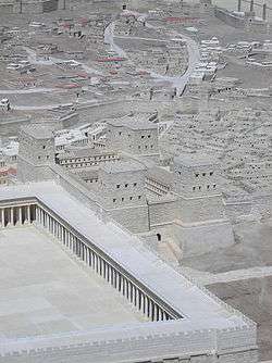
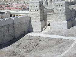
The Antonia Fortress was a military barracks built over the Hasmonean Baris by Herod the Great. Named for his patron Mark Antony, a pre 31 BC date is certain for the Fort as Mark Anthony was defeated by Octavius (later Augustus Caesar) at the sea battle of Actium in 31 BC. Built in Jerusalem on the site of earlier Ptolemaic and Hasmonean strongholds, the fortress was built at the eastern end of the great wall of the city (the second wall), on the northeastern side of the city, near the Temple Mount and the Pool of Bethesda.
Description
Although modern reconstructions often depict the fortress as having a tower at each of four corners, the historian Josephus repeatedly refers to it as the tower Antonia, and stated that it had been built by John Hyrcanus for storing the vestments used in the Temple.[1] However, Josephus states:
"The general appearance of the whole was that of a tower with other towers at each of the four corners; three of these turrets were fifty cubits high, while that at the south-east angle rose to seventy cubits and so commanded a view of the whole area of the temple."[2]
Some archaeologists are of the opinion that the fortress was only a single tower, located at the south-east corner of the site;[3] for example, Pierre Benoit, former professor of New Testament studies at the École Biblique, having carried out extensive archaeological studies of the site, concurs and adds that there is absolutely no [archaeological] support for there having been four towers.[4]
Josephus attests to the importance of the Antonia: "For if the Temple lay as a fortress over the city, Antonia dominated the Temple & the occupants of that post were the guards of all three." Josephus placed the Antonia at the northwest corner of the colonnades surrounding the Temple. Modern depictions often show the Antonia as being located along the north side of the temple enclosure. However, Josephus' description of the siege of Jerusalem suggests that it was separated from the temple enclosure itself and probably connected by two colonnades with a narrow space between them. Josephus' measurements suggest about a 600-foot separation between the two complexes.
Why did the two 600-foot aerial bridges disappear from the pages of history? They were mentioned in two 19th-century books written by scholars Lewin, Sanday & Waterhouse, who probably read Josephus in the original Greek, whilst others, later relied on William Whiston, an 18th-century translator. We cannot know if Whiston was influenced by traditional thinking but he probably decided that Josephus had erred when he gave the length of the aerial roadways as a furlong (Stadion), so Whiston used the words “no long space of ground”. War VI, 2, 144
Based upon Jerusalem’s topography and the impossibility of placing Fort Antonia six hundred feet further north of the alleged Temple Mount, Whiston’s translation obscured their existence, although there are ten references in Josephus to these bridges.
Prior to the First Jewish–Roman War, the Antonia housed some part of the Roman garrison of Jerusalem. The Romans also stored the high priest's vestments within the Fortress.
During the defence of Herod’s Temple, supposedly the Jewish fighters demolished the Tower of Antonia. Josephus is adamant the Jews had no chance of destroying a huge Roman fort with 60-foot walls, defended by thousands of Roman troops. It’s the destruction of the two 600-foot aerial bridges that is meant. It fulfilled the prophecy: “When square the walls, the Temple falls.” Roman soldiers then hastened to construct siege banks against the Temple’s north wall. Battle lasted until they seized the sanctuary.
Site of Pilate's Praetorium?
Traditionally, it has been thought that the vicinity of the Antonia Fortress later became the site of the Praetorium, and that this latter building was the place where Jesus was taken to stand before Pilate (see Pilate's court). However, this tradition was based on the mistaken assumption that an area of Roman flagstones, discovered beneath the Church of the Condemnation and Imposition of the Cross and the Convent of the Sisters of Zion, was the pavement (Greek: lithostratos) which the Bible describes as the location of Pontius Pilate's judgment of Jesus;[5] archaeological investigation now indicates that these slabs are the paving of the eastern of two 2nd century Forums, built by Hadrian as part of the construction of Aelia Capitolina.[4] The site of the Forum had previously been a large open-air pool, the Struthion Pool, which was constructed by the Hasmoneans, is mentioned by Josephus as being adjacent to the Fortress in the 1st century,[6] and is still present beneath Hadrian's flagstones; the traditional scene would require that everyone was walking on water.
Like Philo, Josephus testifies that the Roman governors stayed in Herod's Palace while they were in Jerusalem,[7] and carrying out their judgements on the pavement immediately outside it;[8] Josephus indicates that Herod's palace is on the Western Hill (Upper City)[9] and it has recently (2001) been rediscovered under a corner of the Jaffa Gate citadel according to Jacqueline Schaalje, "Israeli Archaeologists Discover Herod's Palace", The Jewish Magazine (October 2001}. Archaeologists now therefore conclude that in the 1st century, the Praetorium – the residence of the governor (Praefectus – later Procurator) – was on the Western Hill, rather than the Antonia Fortress, on the diametrically opposite side of the city.[4]
See also
- Herodian architecture
- Ptolemaic Baris
- Hasmonean Baris
- Via Dolorosa, the Antonia Fortress is its starting point
- Struthion Pool
- Bezetha
References
- ↑ Josephus, Antiquities of the Jews 18:4:3
- ↑ B.J. v. 238
- ↑ Pierre Benoit, "The Archaeological Reconstruction of the Antonia Fortress", page 89, in Jerusalem Revealed (edited by Yigael Yadin), (1976)
- 1 2 3 Pierre Benoit, The Archaeological Reconstruction of the Antonia Fortress, in Jerusalem Revealed (edited by Yigael Yadin), (1976)
- ↑ John 19:13
- ↑ Josephus, Jewish War 5:11:4
- ↑ Pierre Benoit, The Archaeological Reconstruction of the Antonia Fortress, page 87, in Jerusalem Revealed (edited by Yigael Yadin), (1976)
- ↑ Josephus, Jewish Wars, 2:14:8
- ↑ Josephus, Jewish Wars, 5:2
10. "For the Temple" by G. A. Henty
External links
Coordinates: 31°46′48″N 35°14′03″E / 31.78000°N 35.23417°E