Api Municipality
| Api Municipality अपी नगरपालिका Khalanga | |
|---|---|
| Municipality | |
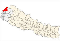
 Api Municipality Location in Nepal | |
| Coordinates: 29°50′N 80°33′E / 29.83°N 80.55°ECoordinates: 29°50′N 80°33′E / 29.83°N 80.55°E | |
| Country |
|
| Zone | Mahakali Zone |
| District | Darchula District |
| Time zone | NST (UTC+5:45) |
| Area code(s) | +977-93 |
Api Municipality (Khalanga) (Nepali: अपी नगरपालिका (खलंगा)) is a municipality located in Darchula District of Mahakali Zone in the Far-western Development Region of Nepal. This municipality was formed on 18 May 2014. It was formed by merging five Village Development Committees: Brahmadev, Chhapari, Dhap, Kante and Khalanga.[1][2] This municipality is named after the Mt. Api of the district.
References
- ↑ 72 new municipalities announced Archived June 18, 2014, at the Wayback Machine. My Republica
- ↑ Govt announces 72 new municipalities The Kathmandu Post
External links
This article is issued from Wikipedia - version of the 11/15/2016. The text is available under the Creative Commons Attribution/Share Alike but additional terms may apply for the media files.