Appenweier
| Appenweier | ||
|---|---|---|
| ||
 Appenweier | ||
Location of Appenweier within Ortenaukreis district 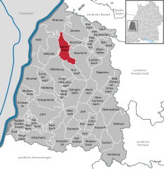
 | ||
| Coordinates: 48°32′23″N 7°58′48″E / 48.53972°N 7.98000°ECoordinates: 48°32′23″N 7°58′48″E / 48.53972°N 7.98000°E | ||
| Country | Germany | |
| State | Baden-Württemberg | |
| Admin. region | Freiburg | |
| District | Ortenaukreis | |
| Government | ||
| • Mayor | Manuel Tabor | |
| Area | ||
| • Total | 38.03 km2 (14.68 sq mi) | |
| Population (2015-12-31)[1] | ||
| • Total | 10,068 | |
| • Density | 260/km2 (690/sq mi) | |
| Time zone | CET/CEST (UTC+1/+2) | |
| Postal codes | 77767 | |
| Dialling codes | 07805 | |
| Vehicle registration | OG | |
| Website | www.appenweier.de | |

Appenweier (Low Alemannic: Appewiir) is a municipality in western Baden-Württemberg, Germany in the district of Ortenau.
Geography
Appenweier consists of the main municipal Appenweier (4,075 inhabitants), Urloffen (4,301 inhabitants), known for horseradish-growing, and Nesselried (1,383 inhabitants). The Nesselried district runs through the Wannenbach valley, while Urloffen lies north of Appenweier.
References
External links
| Wikimedia Commons has media related to Appenweier. |
This article is issued from Wikipedia - version of the 11/14/2016. The text is available under the Creative Commons Attribution/Share Alike but additional terms may apply for the media files.