Arauca, Arauca
| Arauca | ||
|---|---|---|
| ||
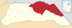 Location of the municipality and town of Arauca in the Arauca Department | ||
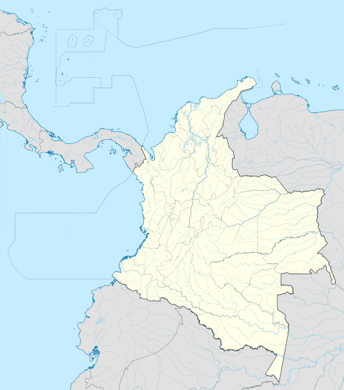 Arauca Location in Colombia | ||
| Coordinates: 7°5′26″N 70°45′42″W / 7.09056°N 70.76167°W | ||
| Country |
| |
| Department | Arauca Department | |
| Founded | 1780 | |
| Government | ||
| • Mayor | Luis Emilio Bello Tovar | |
| Area | ||
| • Total | 5,841 km2 (2,255 sq mi) | |
| Elevation | 125 m (410 ft) | |
| Population (2012)[1] | ||
| • Total | 73,049 | |
| • Density | 13/km2 (32/sq mi) | |
| Postcode | 810001-9 | |
| Area code(s) | 57 + 8 | |
| Website | Official website (Spanish) | |

Arauca is a municipality and capital city of the Arauca Department of Colombia. Its full name is Villa de Santa Bárbara de Arauca, it is located at N 07° 05′ 25″ - W 70° 45′ 42″. The Municipality of Arauca has a total population of 82,149 (2005 census).[2]
History
The Arauca region was explored by the German conquistador Jorge de la Espira, aka Georg von Speyer, in 1536. These early Spanish did not stay because they were on the quest for El Dorado. But later they were followed by Jesuits and land-grantees who founded the first settlements.
Arauca was founded on December 4, 1780, by Juan Isidro Daboín on the site of an indigenous hamlet of about ten families called Guahibo. Arauca was named after the Arauca River which now separates it from Venezuela, which river in turn was named for the indigenous people the Arauca. The area is flat and subject to frequent flooding from the river.
At one point it was the capital of the New Granada Province of Casanare which was much larger than the current Department of Casanare. In addition, the Villa de Santa Bárbara de Arauca, has been:
- Capital of the Republic, under the revolutionary government, constituted July 16, 1816;
- Capital of the Police District (Comisaría especial) since 1911;
- Capital of the Province (Intendencia Nacional) of Arauca, 1955–1991;
- Oil capital of Colombia since 1986;
- Capital of the Department of Arauca since 1991.
Climate
| Climate data for Arauca | |||||||||||||
|---|---|---|---|---|---|---|---|---|---|---|---|---|---|
| Month | Jan | Feb | Mar | Apr | May | Jun | Jul | Aug | Sep | Oct | Nov | Dec | Year |
| Record high °C (°F) | 36.8 (98.2) |
38.4 (101.1) |
39.2 (102.6) |
39.3 (102.7) |
38.4 (101.1) |
36.6 (97.9) |
34.6 (94.3) |
35.4 (95.7) |
36.4 (97.5) |
36.3 (97.3) |
36.4 (97.5) |
35.8 (96.4) |
39.3 (102.7) |
| Average high °C (°F) | 32.7 (90.9) |
34.2 (93.6) |
34.4 (93.9) |
33.3 (91.9) |
30.5 (86.9) |
29.9 (85.8) |
29.4 (84.9) |
30.3 (86.5) |
31.2 (88.2) |
31.6 (88.9) |
31.4 (88.5) |
31.4 (88.5) |
31.69 (89.04) |
| Daily mean °C (°F) | 27.2 (81) |
28.3 (82.9) |
28.6 (83.5) |
27.6 (81.7) |
26.4 (79.5) |
25.8 (78.4) |
25.5 (77.9) |
25.9 (78.6) |
26.3 (79.3) |
26.6 (79.9) |
26.8 (80.2) |
26.7 (80.1) |
26.81 (80.25) |
| Average low °C (°F) | 20.1 (68.2) |
20.5 (68.9) |
21.4 (70.5) |
22.3 (72.1) |
22.3 (72.1) |
22.1 (71.8) |
22.1 (71.8) |
22.1 (71.8) |
22.2 (72) |
22.2 (72) |
22.2 (72) |
21.3 (70.3) |
21.73 (71.13) |
| Record low °C (°F) | 15.4 (59.7) |
15.2 (59.4) |
16.3 (61.3) |
17.3 (63.1) |
18.0 (64.4) |
17.5 (63.5) |
18.0 (64.4) |
17.6 (63.7) |
18.0 (64.4) |
18.0 (64.4) |
18.0 (64.4) |
18.0 (64.4) |
15.2 (59.4) |
| Average precipitation mm (inches) | 13.0 (0.512) |
12.0 (0.472) |
39.7 (1.563) |
130.9 (5.154) |
224.1 (8.823) |
313.7 (12.35) |
304.7 (11.996) |
234.2 (9.22) |
204.3 (8.043) |
186.7 (7.35) |
110.1 (4.335) |
24.6 (0.969) |
1,798 (70.787) |
| Average precipitation days | 1 | 2 | 4 | 11 | 16 | 21 | 20 | 19 | 14 | 13 | 9 | 4 | 134 |
| Mean monthly sunshine hours | 270.2 | 223.8 | 208.6 | 155.1 | 152.8 | 133.4 | 140.5 | 153.7 | 178.7 | 194.0 | 205.5 | 243.2 | 2,259.5 |
| Source: Instituto de Hidrologia Meteorologia y Estudios Ambientales [3] | |||||||||||||
Economy

Since its founding, Arauca’s primary business has been the raising of cattle, and this is still true. But increasingly, since 1984 it is the exploitation of nearby petroleum (oil sands) that has provided the bulk of municipal income in recent years. The building of the bridge, Puente José Antonio Páez, connecting it with Venezuela stimulated the economy, as did completion of the highway to Bogotá, known as The Route of the Liberators (La Ruta de los Libertadores). Arauca is now on the main surface route between Caracas and Bogotá.
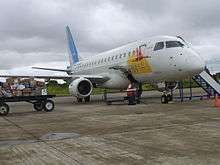
Transportation
References
- ↑ "World Gazetteer". Archived from the original on May 15, 2012.
- ↑ Boletín Censo General 2005 - Perfil Arauca/Arauca
- ↑ "Climate of Arauca-Table of Values" (in Spanish). Instituto de Hidrologia Meteorologia y Estudios Ambientales. Retrieved September 6, 2012.
External links
Municipalities in the Arauca Department | ||
|---|---|---|
Coordinates: 7°05′25″N 70°45′42″W / 7.09028°N 70.76167°W